Showing posts with label teesta bazar. Show all posts

Tuesday, October 28, 2025

Extreme rainfall event in Kalimpong district: 04/05Oct2025 ('Impact on Teesta Bazar')


The first photographic records of major flooding at Teesta Bazar is of the October 1968 disaster when extensive portions of the settlement were washed away by the Teesta River. The event also led to the collapse of the Andersen Bridge — a key river crossing at Teesta Bazar — reportedly as a result of the sudden failure of a landslide-dammed lake located further upstream.
Subsequent decades saw recurring flood impacts in the area. In October 2023, Teesta Bazar was severely affected by a Glacial Lake Outburst Flood (GLOF) originating from the upper Teesta basin. This event caused extensive damage along the Teesta valley and was documented in detail by SaveTheHills (STH).
In July 2024, the locality again experienced significant flooding. Despite detailed recommendations submitted by STH regarding necessary mitigation and risk-reduction measures following the 2023 event, most corrective actions remained unimplemented. Consequently, the warning issued in the 2024 report — “Failure to take timely corrective action will mean a repetition of this whole scenario once again in 2025” — was validated when a similar flood event reoccurred in October 2025.
This pattern underscores the urgent need for comprehensive and coordinated flood mitigation interventions at Teesta Bazar, including structural and non-structural measures, to prevent further recurrence of such disasters in the future.
As expected the town again experienced major floods during the deluge of 04/05/Oct2025. STH photographer Praveen Chhetri was available at site to record the event:
Submerged Darjeeling - Kalimpong road: Two women from Teesta bazar wistfully look at the flooded Kalimpong-Darjeeling road on 05Oct2025. 
I took the photo (below) from almost the same spot on the Teesta bridge in 2024 when the river had receded and the submerged homes alongside the road were visible.
This road passes thru Teesta bazar and every time it is flooded, we have to take a lengthy 6hr detour instead of the normal 2hrs to/from Darjeeling.
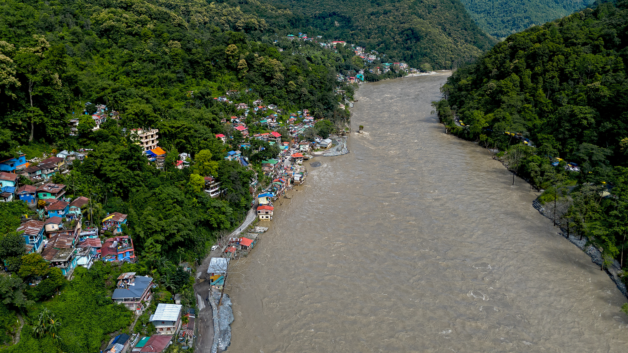
Drone image of the flooded Darjeeling-Kalimpong road at Teesta bazar on 05Oct2025
On 05Oct2025, the Teesta submerged this junction of NH10 and the road to/from Darjeeling (where motorcyclists have assembled). In the distant, the Teesta bridge linking Gangtok and Kalimpong is visible - the river is huge and stretches from one bank to the other.
Trees, stumps and debris were again dumped on the Darjeeling-Kalimpong road below the Teesta bridge by the floods of 05Oct2025.
Almost an annual event - flooded homes in Teesta bazar on 05Oct2025.
The Teesta flowing bank to bank on 05Oct2025. NH10 which connects Siliguri to Gangtok is blocked at Rabi Jhora which is a small flooded bridge on the right bank. This extreme event took place at the peak of festivities and Puja season with hundreds of vehicles choking the highways and roads. 
All photos (except one taken in 2024) by Praveen Chhetri @ Junkeri Studios, Kalimpong. My grateful thanks to Praveen (junkeristudio@gmail.com) for photographing the event as a historical record. 

Praful Rao
SaveTheHills
savethehills@gmail.com
9475033744

Thursday, December 19, 2024

A post GLOF look at the Teesta bazar and its vicinity (Part -1)

A few days ago, a friend called from Mangan, the headquarters of North Sikkim district, eager to witness the aftermath of the Teesta Valley Glacial Lake Outburst Flood (GLOF) that occurred on October 4, 2023. She expressed difficulty in identifying the affected areas. I empathized, recalling how we began documenting the disaster through photographs and recordings on the very day it happened.

Over a year has passed, including a full monsoon season. During this time, nature has altered the landscape, roads and homes have been repaired, and damaged machinery and assets have been removed or replaced. These changes underscore the importance of promptly documenting disasters, at least through photography, to capture the immediate impact before recovery efforts and natural processes transform the scene.

The Glacial Lake Outburst Flood (GLOF) on October 4, 2023, caused the Teesta River's level to surge by approximately 3 to 4 meters throughout the valley. This event deposited substantial silt and debris along the river's course. While monsoon floods have since washed away some of these deposits, the river is gradually reestablishing its natural channel—a process that can span several years. Consequently, we must brace for potential challenges during upcoming monsoon seasons. The current dry season offers an ideal window for implementing necessary preparations; however, I have observed a concerning lack of such proactive measures and towards this end we have voiced our concern by writing to the highest levels in the country.

With regard to the disaster, I made a visit on 18Dec2024 to the Teesta bazar and its vicinity to check and photograph the area. My report:

a. River Condition:
The Teesta River has shed much of the silt and debris left by the October 2023 GLOF and is regaining its characteristic emerald-green winter hue. In some areas, the river has carved out a defined channel, reducing its erratic flow over the 3-4 meter thick debris layer deposited during the disaster.

b. Disaster Mitigation Efforts:
No visible disaster mitigation efforts were underway in Teesta Bazar or its surrounding areas. Residents I spoke to expressed deep frustration over the lack of action.

c. Local Economy - Rafting Resumes:
Rafting activities have resumed in the Teesta/Labar Boatay area, providing direct and indirect employment to approximately 2,000 people.

d. Tribeni Covid Hospital:
A footpath to the Tribeni Covid Hospital is functional. However, much of the hospital's infrastructure has been either looted or washed away by the floods, leaving it in a dire state.

e. NH10 Road Conditions:
On the short stretch of NH10 I traveled, significant repair work was underway near Likhu Bhir. However, areas around the 29th mile and Melli remain vulnerable, with visible cracks and sinking sections near the riverbank. These areas are at serious risk of collapse during the next heavy rains.
Placed below are images of the area:


Documentation of parts of the above report was supported by Royal Enfield, as part of their Social Mission Initiative


Praful Rao
SaveTheHills
savethehills@gmail.com
9475033744

Monday, November 25, 2024

Media coverage of our Memo on the Teesta valley disaster problem

On 18Nov2024, we had couriered the hard copies of our memo requesting urgent mitigation action in the Teesta valley in the few dry months we have before the monsoons again wreak havoc in 2025.

 'The Hindu' is an old and prominent national newspaper and I am very glad that they carried the Teesta Valley GLOF disaster story almost in its entirety:


(Link: https://www.thehindu.com/sci-tech/energy-and-environment/teesta-valley-disaster-glof-2023-sikkim-west-bengal-act/article68885161.ece)
Subsequently, we emailed the memo to Mr Rajendra Singh, Head of Dept NDMA and Mr D Nariala (IAS), PS of Disaster Management Department, Govt of W Bengal.

Affected citizens of Teesta Bazar blocking the road in protest against Govt inaction at Teesta on 22Nov2024.

Praful Rao
SaveTheHills
9475033744
savethehills@gmail.com

Monday, October 7, 2024

Rainfall data of Sep 2024 of some towns in Sub-Himalayan W Bengal and Sikkim

Teesta river and bazar on 29Sep2024, a few days after heavy rain on 27/28Sep. The river had receded quite a bit yet it flowed nudging the bazar and the Darjeeling road at many places. The river is still swift and flows from one bank to the other.
Notice the way the heavy rain is all stacked up in the last week of the month with the first few weeks being deficient in rain.
A dramatic shift from deficient rain upto 25Sept followed by a large surplus thereafter.


The impact of the heavy rains in the month end has already been covered in a separate post here


Praful Rao
SaveTheHills
9475033744
savethehills@gmail.com

Friday, October 4, 2024

Commemorating the 'Teesta Valley GLOF of 04Oct2023' with photos of the event and its aftermath.

A woman washes the money she recovered while scavenging for lost property in a flood affected area of Rangpo (Sikkim) on 06Oct2023 - photo credit Praveen

As I write, it is very early morning on 04Oct2024 and it was exactly at this time last year that I was up at my home in Kalimpong, trying to contact and verify with people, mainly in Sikkim, about whether a GLOF had actually taken place in the Teesta valley.
In the meantime my cellphone was receiving images and videos of the floods as the wall of water tore down the valley. Just verifying what was happening in order to report and record it accurately  kept me engaged the entire day and next, while my young friend and photographer Praveen Chhetri visited Teesta Bazar which the GLOF hit around 4am. He recorded the impact of the GLOF as it happened.
I did not know then that this process of recording the GLOF and its impact would keep us busy for an entire year but it has - and has required numerous visits to many parts of the Teesta valley including one trip made in Nov2023 to Chungthang where the 1200mw Sikkim Urja hydroelectric dam was destroyed by the GLOF.
What we have in this blog is perhaps the most comprehensive photographic record of what was the largest GLOF which took place in the Himalayas. Praveen and I certainly have hundreds of images, many videos and voice recordings of the interviews of affected people that we did during the course of the year.

    Interviewing an affected person who had lost everything to the GLOF - Rangpo (Sikkim), 06Oct2023.

This post, where I publish some photos is only to commemorate that momentous event which changed the lives of so many
Lest we forget...

Army personnel recovering buried vehicles at Bardang (Sikkim) on 06Oct2023. 22 army persons who were a part of a convoy were swept away by the GLOF here
Landslide affected areas of Naga, a village between Mangan(district headquarters, North Sikkim) and Chungthang in Nov2023 (telephoto image from opposite hill). The village was almost entirely evacuated during the monsoons of 2024.
A man crosses the Teesta river on a bamboo bridge at Toong, North Sikkim in Nov2023. The bridge connecting Chunthang to Mangan was torn down by the GLOF
GLOF affected areas between Chungthang and Lachen town where there was no impact of the Sikkim Urja dam burst. The scale of the devastation caused by the GLOF alone is apparent in the photo - photo courtesy Dathup, Lachen.
GLOF eroded parts of NH10 between Teesta bazar and Melli in Oct 2023. With the Teesta river running 4-5m above the pre-GLOF levels, the erosion of NH10 increased remarkably in 2024.
Debris and vegetation which the GLOF had dumped on top of the NHPC Stage V 510MW dam at Dikchu, SIkkim. The Teesta river 'over toppled ' ie went over the dam at this site.
Tree stumps and debris inside the NHPC Stage VI dam at Sirwani, Singtam (Sikkim), Nov2023
Vehicles strewn around like battered toys, on the banks of the Teesta at Singtam (Sikkim).
Part of Teesta town (Krishnagram or Bhasuwa) literally sliding slowly into the river - Sep2024
A marooned COVID hospital on the banks of the Teesta and Rangeet rivers at Tribeni, (Darjeeling district) - Sep2024. There is no road access to the hospital with the Teesta river having kept large parts of the access road submerged after the GLOF.
Rangpo town in Sept24. One year after the GLOF, parts of the town are still trying to recover. The river still flows uncomfortably close to the town and the police checkpost (green roofed structure on the top left is literally tilting into the river.
Undoubtedly one of the most iconic images of a GLOF.
Drone image taken by Praveen at around 11.00am on 04Oct2023 from the Teesta bridge when the GLOF was passing thru the area. As can be seen much of the Teesta bazar was already submerged.

Documentation of parts of the above report was supported by Royal Enfield, as part of their Social Mission Initiative


With
Praveen Chhetri (9733185815)

Praful Rao
SaveTheHills
9475033744
savethehills@gmail.com


Wednesday, July 24, 2024

Photo report on Teesta bazar and its vicinity - 21July2024


The Teesta valley GLOF, hit the town of Teesta at approx 4am on 04Oct2023 and caused much devastation which we have recorded in this blog here. What was clearly apparent then was that unless some urgent engineering steps and other short term measures to mitigate the impact of the GLOF were taken quickly, the whole area would again relive the disaster when the summer monsoons arrived.
Unfortunately, except for some very temporary measures like evacuating people to relief camps, doling out some compensation and reopening roads, we did not take advantage of the dry season when the Teesta river was more manageable and of course, we had the general elections of  April2024 which provided a good reason to sideline disaster management requirements of the GLOF.
I have visited the Teesta bazar area numerous times (I live in Kalimpong which is 17km from Teesta bazar and it takes me 40mins to reach there), interviewed affected people, given many presentations and written to the NDMA, SDMA's of Sikkim, W Bengal and other political representatives with a view to highlight the seriousness of the condition in the Teesta valley and especially in the low lying areas where the river is now flowing at elevated levels.
I spent 5hrs at the Teesta bazar and its vicinity again on 21July2024 and my observations are as follows:

Weather conditions in our area
   * The monsoon rainfall generally peaks in July but we still have not had really heavy and prolonged rain in our region.
   * IMD had issued 10 days of RED warning for heavy rain around mid June2024 and north Sikkim did get heavy rain on 13Jun2024. Impacts:
         - the Teesta river flooded parts of Melli, Teesta bazars.
         - Darjeeling-Kalimpong road was submerged,
         - NH10 is closed, mainly due to landslides at Likhu Bhir
   * However, for the past 6 days or so, we have seen a drastic decline in rainfall in our area due to the formation of a low pressure area in the Bay of Bengal. This has resulted in the water levels falling in the river as such the Darjeeling- Kalimpong road is open. However, NH10 continues to be closed for repairs since 01July2024.

Impact on Teesta River

View of the river from the Teesta bridge and looking northwards towards Sikkim. Even though water levels had reduced because of less rain, the river was still very swift and flowing bank to bank
View of the river from the Teesta bridge looking southwards towards Siliguri. The Darjeeling-Kalimpong road on the right is now useable - but only so long as the water level remains low.
Teesta flowing from bank to bank near Likhu bhir (27 02 27.3 N  88 25 39.6 E, Elev 240m)
Teesta river opposite Geil Khola. This is the only place (27 01 48.3 N 88 25 43.0 E, Elevn 225m) where I saw that the river has moved away from a populated area and is now confined to the opposite bank - everywhere else, it was flowing from bank to bank.
Teesta river at Rabi Jhora (27 03 0.5 N 88 25 38.6 E, Elevn 534m) where it is flowing at the same level as NH10. Teesta bridge linking Sikkim and Kalimpong can be seen in the background.

Impact on Populated Areas
I visited the Teesta bazar and tried to access Melli (S Sikkim) and Bangay Bazar in the same area but could not do so due to a landslide and a flooded bridge. It is a grim and sorry tale which I witnessed in the entire region - since the highway is closed, road traffic has drastically reduced in all the areas as such business is dead for those who have restaurants and tourism related work in the valley. Rafting, another money earner for the local youth has also stopped due to the river being in spate.
The river is now running close to low lying populated areas and in the case of many homes and buildings, the Teesta river is lapping around in the ground floor rooms of the dwellers and I was told by a hotel owner at Melli (W Bengal side) that he has to keep checking the water level in the basement with a torch thru much of the night.
All this, with almost 3 months of rains ahead.

Melli (South Sikkim)
- 27 05 12.5 N 88 27 9.7 E, Elevn 230m
Melli is a small town in South Sikkim located across a bridge over the Teesta river. I found that there was no vehicular access to Melli after the main road to the town was destroyed by a landslide MORE than a month ago.
All vehicles destined for Melli town were parked at a petrol station almost a kilometer from the town from where people had to walk to/from the town. We were told that the carriage charges by porters for ferrying goods to the town was Rs 100 per 10Kgs!
This landslide took place more than a month ago and has cut off vehicular access to Melli town in Sikkim since then. When I asked why the repair was taking so long, I was informed by the locals that whatever the bulldozers cleared during the day is nullified at night with parts of the hills crumbling and blocking the road again. One has to walk to/from Melli town on an 'upper route' above the landslide area (27 05 13.4 N 88 27 9.7 E, Elevn 226m).
Time constraints prevented us from walking to the town but we know that the Melli stadium which was painfully cleared of debris all thru winter was once again flooded on 13Jun2024.

Geil Khola (27 01 41.2 N 88 25 40.0 E, Elevn 230m)
This is a sleepy little hamlet on NH10 which was badly impacted by the GLOF last year. The village was not affected by the deluge of Jun2024 and nothing seems to have changed since Oct2023. All the houses which were buried then, are still buried and with the highway closed for 3 weeks, most of the small restaurants and hotels were also closed.
Geil khola on 21July2024

Bangay Bazar (26 59 58.3 N 88 26 35.8 E, Elevn 211m)
We have covered this area in an earlier blog here when 19 homes had been inundated during the GLOF. The conditions seemed similar when I visited the place on 21July2024 - Relli river was again flowing over the bridge to the village and there seemed to be little activity in the village itself.

Teesta Bazar
(27 03 23.1 N 88 25 30.4 E, Elevn 220m)
Teesta bazar was badly affected by recent rains in June and July2024 and we have reported on the condition of Bhasuwa or Krishnagram in the town, in our last blog. Our observations on places we visited is as follows:
Many homes and structures which are NOW on the banks of the river are submerged. Locals clearly state the river 'was always way down below' and that it is only post GLOF2023 that the river is so high and so close.
Submerged homes on the banks of the Teesta and the Darjeeling-Kalimpong road at Teesta bazar which also routinely gets flooded during heavy rain in the valley.
The Teesta river runs close to all these houses which today find themselves on the banks of the river at Teesta bazar. Politicians and media people visiting these areas often ask the people 'why did you all build your homes so close to the river?' To which they answer, 'No sir! we did not build our houses close to the river, it is the river which has come close to our homes' - this is wholly correct.
People still live in most of these houses and the river levels seen here are after 6 days of little or no rain in our region.

GTA Covid Hospital at Tribeni
We could not visit the hospital since there is no road access.

Condition of NH10 and roads

National Highway 10 (NH10) - closed since 01Jul2024
In the time available to us on 21July2024, we could only cursorily survey approx 12.5 km of the NH10 which lies between Melli and Teesta Low Dam Project III. This section of NH10 is also the most problematic maintenance-wise and has always had some major landslides which have continuously troubled both the agencies who maintain the highway and also travellers. However, after the 2023 GLOF, the scenario has changed entirely with the Teesta river flowing almost at road level in many places - causing the saturated road bench to slump into the river at places. I have placed photos of areas which are damaged below:
This is close to the Teesta bridge and failure of this slope would impact both NH10 and the Darjeeling-Kalimpong road which is directly below (27 03 8.0 N 88 25 36.9 E, Elevn 588m).
This is the infamous 27th Mile landslide which troubled us for years. After suitable treatment, it had somewhat stabilized recently and it remained stable even after the GLOF. The recent rains seems to have reactivated it. There was a bulldozer stationed here, indicating it has become a threat (27 01 1.6 N 88 26 5.6 E, Elevn 236m).
Image of Likhu Bhir landslide in Apr2024 when the highway was closed for repair (credit: Mukesh Sharma, Kalimpong)
Likhu Bhir (both photos), is an old landslide which was stable for years, until the GLOF activated it on 04Oct2023. It is a very troublesome slide on NH10 now (27 02 34.8 N 88 25 43.3 E, Elevn 250m)
With a fast flowing river so close to the road bench, parts of the road slumping into the river is common. This is at Likhu Bhir and the workers informed us that IRCON tippers were dumping excavated soil from tunnels into the river to 'push' it away from the road.( 27 02 11.6 N 88 25 38.4 E, Elevn 234m)
This road slump is near Baluatar, seen in the distant (27 00 41.2 N 88 26 23.7 E, Elevn 262m)
Rabi Jhora, which is just a stones throw from Teesta bazar. Notice that the level of the river is almost the same level as the highway ( 27° 2'59.71"N, 88°25'35.06"E Elevn 534m).
NH10 approximately opposite Melli. The edges of the highway are slumping into the river at many places (27 04 56.4 N 88 26 47.2 E, Elevn 285m)
Laborers houses on the river bank on NH10 near Melli. Some have abandoned their homes but it appeared that some were steadfastly staying put (27 05 1.2 N 88 27 4.7 E,
Elevn 233m).
NH10 opposite Melli town. With the river flowing at much higher levels due to the GLOF, parts of the saturated highway are crumbling into the river. This phenomenon was observed even before the GLOF and largely due to dam activity but now with the GLOF, this is more frequent.

Darjeeling - Kalimpong (road via Teesta Bazar)
A large section of the above road was submerged by the GLOF 04Oct2023 and was only reopened for use by light vehicles on 21Oct2023. It was plain to see that with the river flowing barely a few feet below the road level around the Teesta bridge, that the road would again be inundated when the river level went up.
Darjeeling- Kalimpong road
after the GLOF on 22Oct2023 . Notice the level of the road and the river.

That is exactly what happened on 13Jun2024, when the river levels rose following heavy rains in  North Sikkim.
Photo of flooded Darjeeling- Kalimpong road in mid-Jun2024 (courtesy - Mukesh Sharma, Kalimpong)

When we visited Teesta Bazar on 21July2024, after 6 days of almost dry weather, the river had receded and the road was dry except for small patches of water. Yet what we were told by the locals near the road is that the moment it rains heavily, the road would again be submerged.
The Darjeeling-Kalimpong road on 21July2024. This entire road was flooded on 13Jun2024 and will again be flooded the moment the Teesta river level rises due to heavy rain in the catchment areas. So traveling to Darjeeling and back (normally a 3 hour trip) becomes a guessing game. Add to the fact that hundreds of tourists normally plan their holidays between Darjeeling and Gangtok and have to transit thru this area - while going to Darjeeling - for them it will be a harrowing and uncertain experience.


Tribeni hospital access road (27 04 2.4 N L 88 25 36.5 E, Elevn 223m) :
Road access to the hospital at Tribeni was never restored after the 4Oct2023 GLOF because the Teesta river kept parts of the road always submerged. This was so when we photographed the road on 21July2024 (see top photo)
Entry point of the Tribeni Hospital access road on 21July2024. I have visited this area very often over the past year and with each visit noticed the river eroding more parts of the access road. An image of the same area in Nov2023 but viewed from the opposite direction is below.
Much of this area is now under water and whereas vehicular movement was possible in Nov2023, it is impossible now.

Recommendations

1. We, once again request that an independent team of experts and scientists visit the Teesta Valley DURING the monsoons 2024 to see and understand the devastation and plight of affected people in Sikkim and W Bengal.

2. Appropriate engineering mitigation measures to control the river and protect population centers and roads, along with proper allocation of funds and resources in the entire Teesta valley maybe implemented based on the report of such an expert committee.

3. Mitigation measures in the affected areas maybe executed sooner than later, keeping in mind that no effective intervention can be undertaken during the monsoons when the river is in spate and our road communication is decimated by landslides.

Failure to take timely corrective action will mean repetition of this whole scenario once again in 2025.


Praful Rao
SaveTheHills
savethehills@gmail.com
9475033744