Zanak, at the base of the aptly
named Sentinel Peak, is the last outpost on the lesser used but religiously and
historically important Chorten Nyima La route to Tibet. The ITBP personnel
stationed there first raised the alarm on the South Lhonak Glacial Lake
Outburst Flood (GLOF) and possibly saved the lives of many people in the path
of the ravaging flood.
South Lhonak Lake, like many other
glacial lakes, is meltwater stored behind a fragile dam created by debris and
ice left behind by the snout of the retreating glacier. The 1950 Swiss Foundation map of Sikkim,
based on earlier Government of India surveys and still used today by trekkers
and mountaineers, does not show a lake at this location. The lake has grown from nothing to its
present dimensions of more than 200 standard football pitches within a span of
less than a hundred years. The glacier is
expected to recede further and the size of the lake will increase in the very
near future. The volume of water stored is thirteen times the storage of the
erstwhile Teesta Urja reservoir. It is
estimated that half this volume spilled out during the October GLOF event.
This is a story repeated again and
again in others parts of the high mountains as the ice cap starts melting at an
accelerating rate due to the effects of climate warming. The Eastern Nepal, Sikkim and Bhutan regions
are considered a hotspot for GLOF activities.
In Sikkim, the total area covered by ice caps is larger than the size of
some of the districts. The Swiss
Consortium, in partnership with National Disaster Management Authority (NDMA)
is studying some of these lakes. They
have compiled a list of twenty five lakes in Sikkim that have been red-flagged
by different agencies as being potentially dangerous. Twenty four of these are located in North
Sikkim, almost equally distributed along the Lachen and Lachung axes and one in
West Sikkim. With increased melting and
the recession of glaciers, more lakes are expected to form or increase in size,
making new areas in other areas of Sikkim vulnerable to GLOF.
Sikkim’s limited experience with
mitigation measures for dangerous lakes, like siphoning of the same South
Lhonak in 2016 and controlled breaching of Mantam in 2017, has met with at best
limited success. The NDMA-Swiss Consortium project involves studying the South
Lhonak Lake and the Shako Cho as exemplars to suggest mitigation measures or to
design an Early Warning System. Without
ground access, the Swiss experts had already completed the desktop studies
based on satellite imagery. Due to
security reasons, the team could only make its first field visit in September
of 2023 but before the team could even take stock of their visit, South Lhonak
Lake surprisingly burst on October 3rd.
It is difficult to create an
accurate time line for the GLOF event and the arrival/peak flows at different
towns as both public and official reports vary considerably. This is due to the fact that the flood
happened in the middle of the night and it builds up gradually from first
arrival to peak flood levels over a
matter of hours. The ITBP camp noticed
the level rise in the Goma Chu, the effluent stream from South Lhonak at about
10.30 at night (the Print), though the triggering landslides and the breaching
of the lake must have happened at least hours earlier. In India, Central Water Commission (CWC)
monitors flows, including GLOF, in all the significant rivers through a network
of instrumentation. Hydrologist/activist
Himanshu Thakkar writes in his blog that the automatic stations upstream of
Dikchu, including Lachen stopped reporting sometime before 10.30 pm on October
3rd and, in his opinion, these stations were probably non functional. Downstream of Dikchu, instrumentation show
the river rose by about the height of a three storey building at Khanitar (near
Manipal) and by about a five storey building at Melli where the CWC stations
are located. At these locations, the
floods first arrived at around midnight but took a couple of hours to build up
to maximum flows.
The actual levels recorded at
Khanitar were more than twice as high as predicted in the CWC simulation for South Lhonak GLOF
published in their advisory in 2016.
Gazoldoba near Siliguri, located a couple of hundred kilometres
downstream of the GLOF source, recorded high flows (more than 7000 cumecs above
pre flood flow) despite the flood flowing through a number of manmade and
natural impedances on its long journey downstream. The flood marks recorded at RangRang also
augments this observation that the flows on October 3rd/4th were much higher
than those simulated both by CWC and the Swiss consortium. The flood marks upstream and downstream of
Chungthang could also provide an estimate of the effect of the collapse of the
dam on flood flows.
The dam failure at Chungthang has
highlighted the vulnerability of power projects and the inadequacy of the
existing safety protocols in the face of abnormally high flood flows associated
with GLOFs. The dams are not designed
for overtopping and the amount of water it can manage are conventionally
calculated from hypothetical rainfalls in the catchment area. While repairing and rebuilding the damaged or
collapsed dams, GLOF has to be factored in.
There is a need to have a relook at the hydrological design and flood
response protocols of all existing dams in Sikkim and elsewhere in the
Himalayas. It is reasonable to question
whether the reservoirs were operating at minimum levels in October (monsoon
period) as required by safety protocols and whether the gates were working
properly. There is a need for more
oversight from dam safety committees in the state (if it exists) and the centre
at both the design stage and during operations.
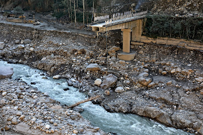
Chungthang is built on a triangular
river terrace at the confluence of the Lachen and Lachung rivers. River terraces are ephemeral geographical
features which seem doubly vulnerable to both GLOF and the shaking of
earthquakes. The October 3rd/4th GLOF
seems to have severely damaged or wiped out most of the river terraces upstream
of Dikchu along with infrastructure and property built on them. Parts of Toong and Rel villages built on
Talus slopes on the Teesta a few kilometres downstream of Chungthang are
collapsing due to undercutting by the flood.
Here, the houses on and below the highway have toppled while those above
the highway have also developed cracks and may not survive the next
monsoon. Reports of cracks in structures
in other areas situated on hill slopes above the banks of the marauding flood
also needs to be investigated empathically.
Whether it is landslides, GLOF or
any other natural disaster, the best mitigation measure is avoidance of the
vulnerable area. Past experience shows
that once the disaster is temporarily abated, people double down and start
rebuilding in the vulnerable areas. Due
to ad hoc decision making and paucity of funds, Government departments usually
put promises of resettlement in the back burner with the passage of time and
slowly forget about it. With our
increasing populations and increased exposure to multiple hazards, there is a
need to legally prevent development and houses in the designated disaster prone
zones and to formulate comprehensive and humane disaster rehabilitation
policies.
Beyond activism and partisan
politics, we need to rationally study and understand these constantly evolving
and growing natural threats to our society and learn to cope with them.
Pemzang
Tenzing
21Jan2024
Mangan
pemzang@hotmail.com