Friday, March 28, 2025

How nature heals: a look at several landslides in Kalimpong

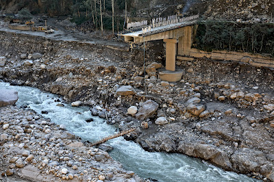
Massive landslide at Bhalukhop (Kalimpong district) on 29Jul2021, following 232mm rainfall in 13hrs. Nature has slowly healed this area over a 4 year period without any engineering mitigation measures being applied.

By no stretch of imagination am I an expert on landslides but having visited numerous landslides over the years and having observed the changes taking place, I believe that under the right circumstances and with time, nature has a remarkable way of healing landslides.
Here are case studies and photos of 3 landslides in and around Kalimpong:

14th mile landslide in Kalimpong

This is a really old landslide and 'a sinking zone' which existed more than 50 years ago. STH has covered this extensively in this blog in 2007 and in 2010

Drone image of 14th Mile landslide on 21Feb2025. The whole landslide area is now covered with trees


Massive Landslide at Bhalukhop (Kalimpong district) on 30Jul2021.

A 232mm rainfall over a 13hr period on 29/30July2021 triggered a massive  landslide in my village, Bhalukhop in Kalimpong; the incident has been covered in a STH blogpost here. I have placed a Google Earth image of the landslide path below:

The length of the slide from crown to toe was approx 1880 ft (measured on Google Earth).
Where the landslide started - at the crest near Deolo Hill.
The mid-section of the slide in Dec2021
Ms Minu Thapa,showing us the extent of devastation in her farm at the base of the landslide in Dec2021
In this Feb 2025 drone image; Ms Minu Thapa's home lies just above the road bend and the entire landslide affected area all the way to the crest is seen covered with vegetation and trees, 4 years after the terrible Jul2021 landslide.
Another drone image of the landslide affected area - showing no trace of the landslide after nature took over.
 

Dhajey, Bara Bhalukhop

As a native of this village, I'm deeply familiar with the landslide issues in our area. To address this problem, the local community employed a traditional mitigation method at Dhajey, which involved a three-step approach:

1. Water diversion: A concrete river training structure was built to channel water away from the landslide-prone area (see top photo).
2. Soil stabilization: Bamboo palisades were constructed to prevent soil erosion during rainfall, allowing pioneer species like mosses and lichens to take root. Under favorable conditions, grasses and small shrubs would emerge within a year, anchoring the soil and reducing erosion. Alternatively, jute matting or fiber could have been used to support the new vegetation (lower photo).
3. Long-term stabilization: Over several years, larger plants like bushes and shrubs would grow, holding the soil together and enabling deeper-rooted species like trees to develop, further binding the soil through nature's "soil nailing" process.

Drone image of this area on 21Feb2025 is shown below👇. The RED circle delineates the area where the bamboo check dams were 'planted'.
Drone image of landslide areas at Dhajey, Bara Bhalukhop👇
1 - A large landslide had taken place here several years ago, which  nature has apparently healed.
  2 - Area where locals applied tradtitional bamboo check dam mitigation measures which has stabilized the place at least for the past 2 monsoons.
 
Documentation of parts of the above report was supported by Royal Enfield, as part of their Social Mission Initiative


Praful Rao
SaveTheHills
savethehills@gmail.com
9475033744


Saturday, March 22, 2025

Updated satellite images of Oct 2023 GLOF affected areas from Google Earth

Google Earth has recently (Jan2025) made available high resolution images of some areas of North Sikkim which reveal the devastating impact of the Glacial Lake Outburst Flood (GLOF) of Oct2023 in North Sikkim. The images below juxtapose the affected areas with historical snapshots, illustrating the catastrophic consequences of the GLOF.

Chungthang town / confluence of the Lachen and Lachung Chu

Chungthang (elevation 1790m/5870', 27.62°N 88.63°E), a town in North Sikkim, is situated at the confluence of the Lachen Chu and Lachung Chu rivers, which merge to form the Teesta river.
On October 3, 2023, an avalanche triggered a GLOF in South Lhonak glacial lake (elevation 5200m/17000'), approximately 75km upstream from Chungthang along the Lachen Chu. The resulting sudden release of around 50 million cubic meters of water made it the largest GLOF in the Himalayas in recent history.
For a detailed account of this event, refer to this publication in Science magazine
STH has closely documented the Teesta valley GLOF of Oct2023 in this blog from the date of occurrence.
Satellite images along with photos of the affected areas are placed below:-

Chungthang town (close up)

Chungthang town (Dec2024)
The still devastated playground and army camp area is seen at the center with the gilded dome of the Gurudwara towards the right side.
Chungthang town playground on 19Nov2023 when we visited the area.

The 1200mw Sikkim - Urja dam and bridge at Chungthang

This was the largest dam in Sikkim and was located downstream of the confluence of the Lachen and Lachung Chu rivers. The 60m rockfill, run of the river dam was commissioned in Feb 20217 at a cost of Rs 14,000crores. Along with the dam, a major bridge (centre top of photo) connecting Chungthang to the rest of Sikkim was also destroyed by the GLOF.
The remnants of Sikkim Urja dam which collapsed in the GLOF on 04Oct2023. Photographed on 18Nov2023, when we visited Chungthang.
A double laned concrete bridge connecting Chungthang to the rest of Sikkim was destroyed by the GLOF here on 04Oct2023

Munshithang (27.6324° N 88.6157° E)

Munshithang, an ammo depot for the Indian army was totally destroyed by the 04Oct Teesta Valley GLOF. On receiving warning of the rising waters in the Lachen Chu, 92 personnel of the ammo depot moved to  higher ground and thus their lives were saved. However, it was 4 days before they could be evacuated - due to bad weather which prevented helicopter flights.
Nothing could be retrieved of the ammunition and equipment lost to the GLOF.

Toong bridge over the Teesta river  (27°33'0.15"N 88°38'35.17"E)

We visited this area on 19Nov2023 and photographed the bridge and the Toong checkpost both of which were destroyed by the GLOF (below)

There was only a small bamboo bridge across the Teesta for pedestrians to cross the river on foot in Nov2023
The Toong police checkpost had been vacated and dangled precariously from the edge of the road
Another view of the vacated police checkpost in Nov2023
Faced with the sheer necessity of communicating, the local community start constructing a wooden bridge across the Teesta at Toong.

 Naga Gram Panchayat (Mangan district, North Sikkim)

Naga GP is located approx 14km from Mangan (district HQ of N Sikkim district) towards Toong and was one of the worst affected areas when we visited Chungthang on 19Nov2023.

It continues to be a wrecked and desolate place as can be seen from the recent photos (of Dec2024) below (photo credits: Rinchen Lama, IIHS ,Bangalore)
Google Earth has unfortunately not updated satellite images of areas south of Naga area (North Sikkim) which are still of 2022 vintage as such they do not show the impact of the GLOF in these areas.


Praful Rao
SaveTheHills
savethehills@gmail.com
9475033744