Cyclone 'BiparJoy' (09Jun-16Jun2023)
Formed as a 'low' in the Arabian sea in the first week of Jun2023 and intensified into a cyclone. We watched the storm closely and reported on the movement and forecast track of the storm extensively in our What's App group 'Hazard Alerts'.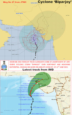
June Weather
The first 10 days of June were HOT and DRY and the monsoon was delayed by several days.

 The rainy spells for Jun2023 came in 3 spells ie on 11Jun, 17Jun and the last week of June2023.
Taking an example of KALIMPONG rainfall, please note:- Kalimpong had the highest rainfall among the 4 towns. Kurseong normally has the highest rain. All this rainfall was concentrated in 17 days, 13 days being bone dry.
- Rainfall on FIVE DAYS ie 11, 17, 26, 27, 28 Jun2023 amounted to 431mm which is equal to 88.8% of the monthly rainfall.
- And what happened was that this rainfall came in short, intense bursts and so the 431mm of rain must have come down with several hours - NOT days.
See previous blogs on this here1 and here2


This rainfall, as expected resulted in numerous landslides.


We will be uploading rainfall data of the previous months in due course.
Thanking all those who contributed the above images in our What's App group 'Hazard Alerts', regretfully the coordinates of the places are not available.
Praful Rao
Kalimpong district,
Darjeeling- Sikkim Himalaya


June Weather
The first 10 days of June were HOT and DRY and the monsoon was delayed by several days.
The rainy spells for Jun2023 came in 3 spells ie on 11Jun, 17Jun and the last week of June2023.
Taking an example of KALIMPONG rainfall, please note:- Kalimpong had the highest rainfall among the 4 towns. Kurseong normally has the highest rain. All this rainfall was concentrated in 17 days, 13 days being bone dry.
- Rainfall on FIVE DAYS ie 11, 17, 26, 27, 28 Jun2023 amounted to 431mm which is equal to 88.8% of the monthly rainfall.
- And what happened was that this rainfall came in short, intense bursts and so the 431mm of rain must have come down with several hours - NOT days.
See previous blogs on this here1 and here2
This rainfall, as expected resulted in numerous landslides.
We will be uploading rainfall data of the previous months in due course.
Thanking all those who contributed the above images in our What's App group 'Hazard Alerts', regretfully the coordinates of the places are not available.


The rainy spells for Jun2023 came in 3 spells ie on 11Jun, 17Jun and the last week of June2023.
Taking an example of KALIMPONG rainfall, please note:
Taking an example of KALIMPONG rainfall, please note:
- Kalimpong had the highest rainfall among the 4 towns. Kurseong normally has the highest rain. All this rainfall was concentrated in 17 days, 13 days being bone dry.
- Rainfall on FIVE DAYS ie 11, 17, 26, 27, 28 Jun2023 amounted to 431mm which is equal to 88.8% of the monthly rainfall.
- And what happened was that this rainfall came in short, intense bursts and so the 431mm of rain must have come down with several hours - NOT days.
See previous blogs on this here1 and here2