Showing posts with label adverse weather. Show all posts

Sunday, April 14, 2024

Our adverse weather early warning work on What'sApp groups in the Darjeeling- SIkkim region: Thunderstorms of 11/12Apr2024 in Kalimpong

After the Teesta Valley GLOF of 04Oct2023, our region has been extraordinarily dry, with the erratic western disturbance activity in the winter months, robbing us of all our winter rain. In Kalimpong we had the first showers after Oct2023, between 19 & 27Mar2024 where we clocked 112.6mm. Thereafter, it has been dry with forest fires again starting in the Teesta Valley.
With regard to early warnings on adverse weather events and disbursement of information on landslides, road blocks etc, SaveTheHills has been running several very active and large What'sApp groups in the Darjeeling-Sikkim region called 'Hazard Alerts or HA' for many years now and the following cloud image on approaching adverse weather was posted in the group on 11Apr2024:

This image was posted on 'Hazard Alerts' WhatsApp group at 1.31pm on 11Apr2024 along with lightning warnings from the IMD 'Damini' (lightning warning) app. Shortly after this was done, the first storm hit our region at around 2.30pm. Wind speeds in gusts reached upto 58kmph.


This storm died down momentarily at around 4.30pm only to pick up again quickly. The following cloud image along with NOWCASTs from IMD were posted to members in the 'Hazard Alerts' What'sApp groups.
Warning posted at 5.36pm to our WhatsApp groups alerting them about another storm which was approaching.
Subsequent cloud images which show the progress of the storm from 6.45pm to 10.45pm on 11April2024


The thunderstorm which hit Kalimpong at 2.30pm on 11April2024, raged right thru the night and only ceased at around 8.00am on 12Apil2024. Surprisingly, we had only 2mm of rain however strong, gusty, westerly winds from Nepal along with lightning prevailed for more than 12hrs. The graphical analysis of the windspeed from our Davis Vantage Pro AWS is placed below:

Though there were no casualties or damage from the storm, what was unusual was its duration considering there was no major weather system (such as a depression/cyclone) near by.
Also what is possible today is to get reliable and accurate information of such weather events in advance and to disburse the same quickly to a large number of people. We have been doing this regularly in WhatsApp since Jun 2016.

Praful Rao
Kalimpong district
Darjeeling-Sikkim Himalaya


Wednesday, November 5, 2014

STH Stormwatch (05Nov2014 update): The low pressure intensifies into a depression


As per JTWC, 'the potential for the development of a significant tropical cyclone within the next 24hr is upgraded to medium'

Praful Rao,
Kalimpong,
Dist Darjeeling


Friday, September 12, 2014

From NDTV : Natural or Man-Made - Who Takes More Blame for J&K Calamity?


Comment by Praful Rao
On 07Sep2013, Dr Prannoy Roy of NDTV hosted a talk show with many luminaries and experts in Disaster Management, captioned 'Is India ready for the next big disaster?';  almost exactly a year on, we have the answer to that question in Srinagar and Kashmir.
Incidentally, in response to a discussion during the show, that TV channels could easily issue targeted early warning (EW) broadcasts in local dialect to communities likely to be affected by extreme weather events, I made a number of requests to NDTV, NDMA and TISS (all participants in the show) for trials of such EW broadcasts to be conducted in Darjeeling district before the onset of the 2014 monsoons - since we are after all, in one of the most landslide prone regions in the country.
No one responded.

Praful Rao,
Kalimpong,
Dist Darjeeling

Wednesday, December 11, 2013

STH stormwatch (11Dec2013) : Cyclone 'MADI' downgraded further into a depression

Cyclone 'MADI' has now been downgraded to a deep depression and is likely to lose strength further to become a depression in the next 6 hrs.


Praful Rao,
Kalimpong,
Dist Darjeeling

Wednesday, August 28, 2013

Satellite Imagery : How reliable is it for rainfall / adverse weather prediction?

Satellite Imagery (both Vis and IR) is an invaluable tool for the lay person to obtain information on the formation,development and movement of weather systems. It has been a part of the STH blog for the past 3 yrs and is an integral part of the "STH Stormwatch" series in which we monitor weather systems that form in the Bay of Bengal.
This information, earlier only available to scientists and meteorologists is now available to anyone with internet connectivity. Having said this however, it  is not advisable to depend on satellite images exclusively as a method to predict rainfall / adverse weather, the next few images will explain
why :


Thus it is clear that satellite images though vital for early warning CANNOT give foolproof warnings. For those interested the link to the Darjeeling "Hurricane" is here.

Rohan Rao,
Kalimpong,
Dist - Darjeeling,
E-mail - rohan.rao1313@gmail.com

Thursday, August 8, 2013

The dire need for more accurate meteorological forecasts


After Cyclone Nilam which battered Andhra Pradesh killing 24 people in Oct2012 and the recent (Jun2013) Uttarakhand disaster, bureaucrats and politicians of the states took pot shots at meteorologists for not giving adequate and more accurate warning about the onset/intensity of adverse weather due to which the devastation occurred. While this sort of behavior maybe habitual amongst babus and their political masters, modern technology places much information about the occurrence/ movement of weather systems in the hands of an internet user and STH has tracked all major weather systems in the Bay of Bengal since 2007.
However, the fact remains that meteorology is still a developing and inexact science and this is problem is further accentuated in remote mountainous regions due to non-availability of sensors and data from such areas which are required to make weather predictions more accurate.
Towards this end, the IMetD website posts a heavy rainfall warning over SubHimalayan West Bengal and Sikkim for almost 80% of the entire monsoon period (see example-Slide1) whereas, in actual fact, we had a 45% deficiency in rainfall during the past week (Slide 2) and also in July2013.
For someone working in Disaster Management this sort of contradiction poses a predicament as crying wolf too often defeats the very purpose of the warning.
The installation of AWS and ARG stations in mountainous areas is a step in the right direction as this would enable better monitoring of rainfall patterns in the hills and the planned installation of Doppler radar in Sikkim would certainly go a long way towards more accurate meteorological predictions in this area.

Praful Rao
Kalimpong,
Dist Darjeeling

Thursday, July 11, 2013

STH Stormwatch (11 July2013) : Reporting a low pressure build up in the Bay of Bengal

 "The low pressure  area over Odisha &adjoining northwest Bay of Bengal and its 
associated cyclonic circulation extending upto mid­tropospheric level tilting southwards 
with height persists. "
(Source : IMD Website)


 A low pressure area has formed in the Bay of Bengal and is now over Odisha and the adjoining North West Bay of Bengal, we will be tracking its movements over the next few days and updates will be posted on this blog.

Rohan Rao,
Kalimpong,
Dist - Darjeeling,
Email - rohan.rao1313@gmail.com

Sunday, June 23, 2013

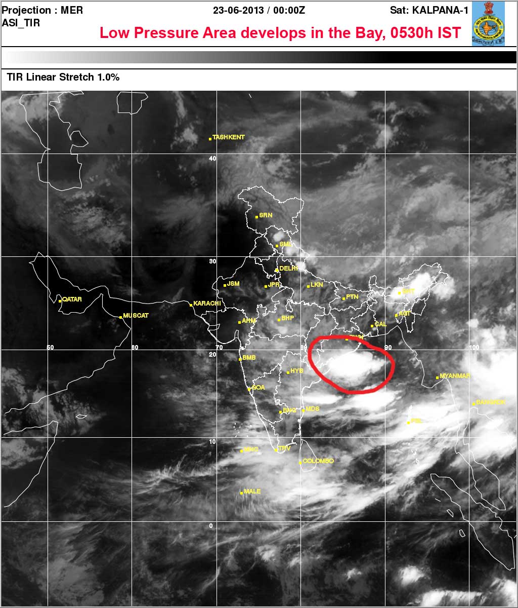
STH storm watch : Reporting a low pressure area in the Bay of Bengal (23Jun2013 - 0530h IST)

As a part of STH storm watch we monitor the activity in the Bay of Bengal continuously during the monsoons  so as to forewarn readers and communities about the formation, movement and intensity of weather systems which may affect us.
Today IMD states :

"The low pressure area now lies over Odisha and adjoining areas of northwest Bay of Bengal associated cyclonic circulation extending upto 7.6 km a.s.l. tilting southwestwards with height."

Praful Rao,
Kalimpong


Wednesday, October 10, 2012

STH storm watch : Another LOPAR in the northern Bay of Bengal


After a relatively quiescent period through the monsoons, in Oct we are seeing a cauldron of activity in the Bay of Bengal with yet another low pressure area (LOPAR) brewing, this time off the coast of Myanmar and shifting slowly towards Bangladesh and W Bengal.
All this is not too good news for us living in the Darjeeling / Sikkim Himalaya and brings back memories of the 1968 disaster which also occurred in early October of that year.

Comment by Praful Rao on 12Oct2012


As a part of STH storm watch we monitor the activity in the Bay of Bengal continuously during the monsoons and I kept a close track of this low as it formed and then gradually shifted on a north-westerly track towards Bangladesh and southern W Bengal.
Since the storm was never categorized as anything more than a "well marked low pressure" very little warning about it was given both in W Bengal and Bangladesh as such I was shocked to read about the devastation, death and havoc it caused in Bangladesh. You can read about it here
But perhaps the silver lining in all this is that even an ordinary person like me can make use of the tools made available by technology today to effectively monitor adverse weather fairly accurately and obtain advance information and warning about it .

Praful Rao

Saturday, October 6, 2012

STH Storm Watch : First Low Pressure Area of monsoon 2012 forms in the Bay of Bengal


Excerpt from IMetD (Kolkata) website

Main synoptic features based on 0830 hrs IST Observations dt.06.10.2012
Under the influence of Upper-air Trough over North Bay of Bengal, a low pressure area has formed over North Bay of Bengal adjoining areas. Associated cyclonic circulation extends upto 2.1 km a.s.l.

Comment by Praful Rao
The activity in the Bay of Bengal has been unusually quiet during the monsoons of 2012 with no lows, depressions or cyclones forming.
STH monitors the activity in the Bay on the internet and reports all adverse weather activity with a view to provide early warning.
On 06Oct2012, I MetD is reporting formation of the first low pressure area of the season in the Bay of Bengal.