Showing posts with label NH55. Show all posts

Friday, July 3, 2020

A pictoral record of the landslides of JUN 2020 in Darjeeling-Sikkim Himalaya


Shown above are the approx timelines when due to the more than normal rainfall in Jun2020, there were numerous landslides in the Darjeeling - Sikkim Himalayas and all occurred during periods of heavy rain. For example, in 6 days (17Jun-22Jun2020) Kalimpong received approx 78% of its monthly rainfall which is when all the landslides in Kalimpong took place.
More specifically:
a. Darjeeling and Kurseong area had landslides just as the SW monsoons entered the region on 12/13Jun 2020. Many of these landslides are documented here.
b. Kalimpong district which had almost no rain during this onset period, had intense rain on 17Jun which triggered a number of slides in the district.
c. Mangan (N Sikkim) and E Sikkim were the only places which had surplus rain over the winter months and continued to have very heavy rain towards June end and that triggered a number of landslides.
In order to maintain a record of the landslide events I am posting verified photos of some of them as submitted by HA members.

Kalimpong:
North Sikkim (Passingdang)
North Sikkim (District HQ: Mangan)27.4979° N, 88.5348° E

North Sikkim (Barfok)
27.509787°N, 88.437531°E
Debris Torrent as seen from across the Teesta from Mangan. No loss of lives, some houses evacuated.

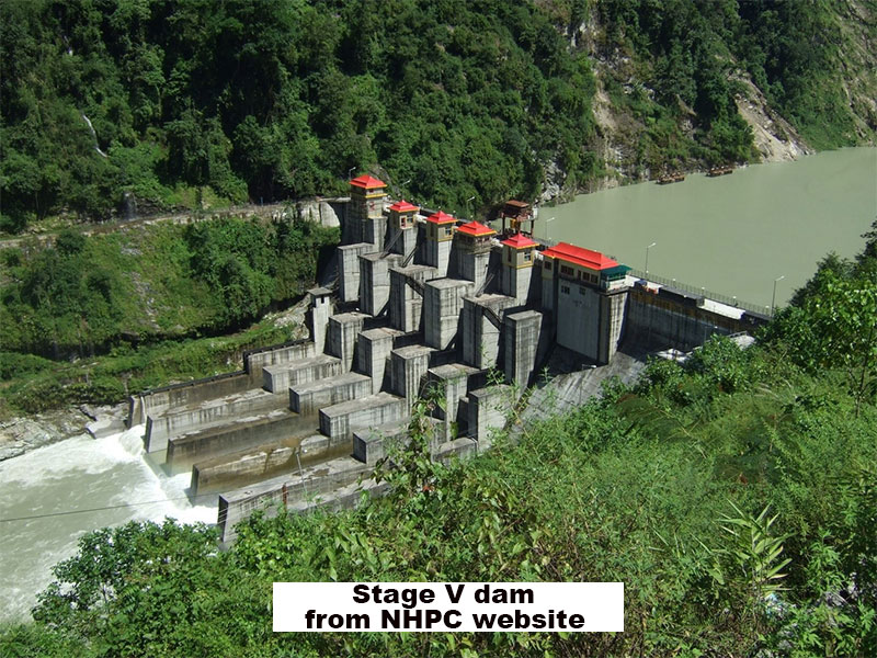
Landslide at NHPC Stage V 510 MW Dam at Dikchu, East Sikkim


Landslip on Dhotrey- Maneybhanjang road (22Jun2020?)
Rimbick- Lodhoma landslide (28Jun2020)
at Chota Hatta, Kankeybong.

Breaches on NH55 (Siliguri to Darjeeling) near Pagla Jhora (Kurseong)
30Jun2020


My sincere thanks to all those who have volunteered their time and effort in 'HAZARDS ALERTS' (Whats App group)  and elsewhere to provide the information and photographs for the above record.

Praful Rao
Kalimpong district
Darjeeling Sikkim Himalaya


Saturday, August 13, 2016

Rainfall data of July2016 for the Darjeeling Sikkim Himalayas and the landslide activity of the month

July 2016 was an extraordinary month for Darjeeling district and North Bengal :-
a. All 3 major towns (Darjeeling, Kalimpong and Kurseong) of the district received more than the monthly average with Kurseong getting approx 3 times the amount.
b. But is in the plains that rainfall was heaviest. Siliguri received 354mm of rain on 24Jul2016 and much of Jalpaiguri district saw some of the highest rainfall in recent memory (Slide 9). The hills of Bhutan also received very heavy rains (Slide 8)resulting in most of the rivers emanating there, flooding the plains of Dooars and Jalpaiguri district.
c. There were many, many landslides (Slide 10) all over Darjeeling district but two killed people. On 09Jul2016, two people were crushed to death when a vehicle (Slide 3) they were travelling in, was hit by a falling boulder at Sweti Jhora on National Highway (NH) 10 (linking Siliguri to Gangtok). Later on 20Jul2016, a whole family of three was wiped out at Finchey Taar, in Lodhoma Darjeeling (Slide 6)  by a landslide following heavy and prolonged rains.
d. On 21Jul2016, the district administration decided to demolish (Slide 7)13 houses on the banks of the Teesta river on NH10 at 29th Mile near Kalimpong. The houses were perilously perched on the banks of the Teesta river and on an area which was known to be subsiding.The occupants had been compensated years ago but were refusing to move.
e. Most of the rain came down in the second half of July when IMD reported the axis of the monsoon trough had shifted close to the foothills (Slide 2). The typical clouding which persisted for much of the month is see on the IR image of 21Jul2016 (Slide 14). IMD also clamped a RED warning for SHWB (Sub-Himalayan W Bengal) and Sikkim for much of the entire month of July2016 and with good reason (Slide 5).
f. The roads and highways suffered tremendous damage. NH10 had a large number of bottlenecks which make driving from Siliguri towards and into the mountains both difficult and dangerous (Slides 3 and 11). NH55 or the route from Darjeeling to Siliguri was equally precarious with the main Rohini route closing down  (Slide 12)on 26July2016 and remain so till date.
Other routes like the Kalimpong-Algarah road fared no better with large chunks of it falling off (Slide 13) or being buried under debris (Slide 4).

Praful Rao,
Kalimpong,
Dist Darjeeling

Saturday, June 27, 2015

Landslide blocks National Highway (NH) 10 (Siliguri-Gangtok) causes massive traffic jams on NH55


With NH10 (formerly31A) blocked by the slide above, literally hundreds of vehicles mainly to Sikkim and Darjeeling scrambled up NH55 yesterday and today causing massive traffic snarls some almost lasting 6-9 hrs.
Read more here

Photo credit : Mr Kundan Yolmo (Telegraph)

Praful Rao,
Kalimpong,
Dist Darjeeling

Saturday, December 8, 2012

Light at the end of the tunnel? : Tindharia/ Pagla Jhora landslides to be repaired soon.


STH has been associated with the Tindharia and Pagla Jhora landslides from Nov2011 when we did a big, well-attended workshop at Tindharia.
Thereafter, in July this year, after further landslides directly threatened the DHR workshop at Tindharia, we spent an entire day in the area checking the drainage and preparing a report for an expert and a friend (see here).
I am glad to say that the PWD will finally be taking up repairs of both the above landslide areas in the near future. You can read the Telegraph article here and this move I am sure, comes directly as an aftermath of the visit to Kolkata by the high powered NDMA team early this week (read here)

My only fear is, that is it too little - too late?

Because the way our bureaucracy groans and grinds along, by the time the work ACTUALLY starts, the monsoons of 2013 will be here and during the rainy season, we all know that major preventive work cannot really be done; all we can do then is fire fighting and emergency crisis management.
The monsoons were mild this year (which poses other problems as regards severe water shortage problems in the Mar-May2013) so we did not have major landslides in our area.

In an age where we should increasingly be expecting the unexpected, aren't we pushing our luck too far to for hope this trend to continue?

Praful Rao

Tuesday, July 17, 2012

100mm of rainfall,14-15Jul2012 :Images from Kurseong


Despite IMetD stating that Darjeeling district has had normal rainfall, STH's rainfall gauges located at Darjeeling, Kurseong and Kalimpong all show less than normal rainfall for May/June/and till date in July2012.
This is further substantiated by the fact that paddy cultivation which normally takes place in July in Kalimpong is on hold since paddy fields which should be flooded by monsoon rain water by this time, are still dry.
Despite this on 14-15July when we had just 100mm of rainfall over a 12hr period, landslides blocked the National Highway (NH) 31A between Gangtok and Siliguri and Darjeeling was also cut off from Siliguri for some time due to the above slips and not surprisingly the landslides took place along roads which are known to be a major cause of landslides the world over
Top photo : Road near Giddah Pahar in Kurseong
Bottom photo: Vehicles held up on the Pankha Bari Road to Siliguri.

Photo credit :STH member of Kurseong Bhushan Chhetri

Praful Rao