We, in the Darjeeling Himalaya Initiative (DHI) submitted a report (with recommendations) to the NDMA and the SDMA’s of W Bengal and Sikkim based on our observations and interactions with affected people in the numerous visits to GLOF affected areas between 27th mile, Kalimpong District, W Bengal and Dikchu in Gangtok district, Sikkim more than a week ago. The reports were substantiated by the many posts and photographic records on the disaster made in the SaveTheHills blog.
Having visited some of the worst affected areas in North Sikkim between 17-19Nov2023, we can only reaffirm what has been reported:
- We need an expert team to visit these areas and advise us the course of action to be taken in the limited time we have before the next monsoons.
- That we should focus on building the resilience of communities in the flood affected areas while continuing with the recovery and reconstruction process, since many of our populated areas in the Teesta Valley in Sikkim and W Bengal will again be affected during the Monsoons 2024.
- That time is of essence.
Report and recommendations on Glacial Lake Outburst Flood (GLOF) affected areas between Dikchu (Sikkim) and Teesta Low Dam Project III (TLDP III, 27th mile), Kalimpong (West Bengal)
Report Drafted by SaveTheHills
Submitted by SaveTheHills and Darjeeling Himalaya Initiative Reported areas are in RED circles

What we people living along the Teesta valley in parts of Sikkim and Kalimpong District of West Bengal, witnessed in the early hours of 04Oct2023 was a rare, dangerous and a huge catastrophe with the Glacial Lake Outburst Flood (GLOF) from South Lhonak Glacier, massive dam breach at Chungthang and subsequent floods causing loss of life and livelihoods and devastating large areas of the valley. The size and scale of the event has far escaped the appropriate attention of both the national and concerned state governments. It has been totally under reported by the mainstream media. Many of us, even from Darjeeling and Sikkim Himalaya have pushed it to distant memories and forgotten that there is massive work ahead with rehabilitation and mitigation.
- When the very turbulent waters of the GLOF from South Lhonak glacier located at 17,300 feet above mean sea level crashed into the already brimming reservoir of the 1200MW Sikkim Urja Dam at Chungthang, the dam was quickly overwhelmed and burst, releasing a wall of water which was 10-15 feet high. This deluge swept through the Teesta valley, destroying everything in its 162 km rampage from the glacier to NHPC Teesta Low Dam Project (TLDP) III at 27th Mile in Kalimpong district.
- This report is an attempt to preserve facts of this humongous event and to urge both government and civil society to recognize and respect the vulnerable fragility of the Himalaya. It is extremely apparent that there is the need to be prepared for more such disasters as the Himalaya gets warmer.
- The fundamental recommendations stem from extensive field visits to GLOF affected regions and in-depth conversations with the affected residents. Having witnessed the profound impact of this catastrophic event on infrastructure and communities, it is crucial to recognize that we have a mere five-month window to initiate remedial actions. Our primary objective is to empower and ready the traumatized community to confront the challenges of the upcoming monsoon season in 2024, ensuring improved safety and resilience, and safer road networks for the thousands who transit each day.
- We have not visited Chungthang and other affected areas in North Sikkim as yet, but have made several visits to GLOF affected areas between Dikchu and 27th Mile (Kalimpong district) and photo essays from our visits are placed in the STH blog http://savethehills.blogspot.com.
- It is requested that this report be read in conjunction with more specific inputs from our photo essays in the STH blog which will amplify the observations that are made below.
 Teesta river in spate at the Teesta bridge, on 04Oct2023 (drone image)

Observations
The Teesta river
- The Teesta is still unusually large and fast for this time of year. As such it is continuously eroding sections of NH10 as well as low lying populated areas like the Teesta bazar.
- The river level, post GLOF is much higher; undoubtedly due to the silt deposits as the river slows down in areas of less gradient. In this regard, Mr Lalitendu Tripathi, Executive Director, NHPC, (North Bengal and Sikkim) stated in an interview with a local TV channel ‘Himal World’ that the level of the whole Teesta Basin had increased by 3-4m due to the debris deposits.
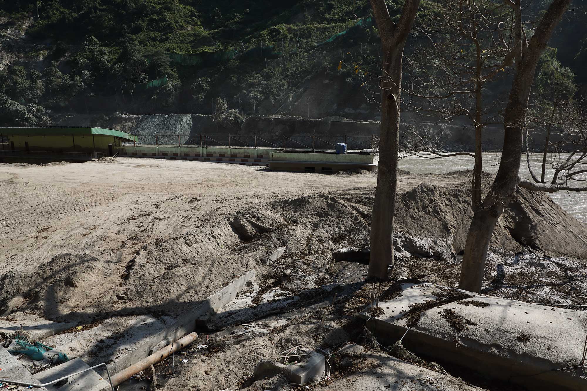
- Locals blame the huge silt deposits by the Teesta on the IRCON project and the tunnel excavations which were dumped on the river banks and which were swept away by the GLOF. To make matters worse, the sludge and sand that is being excavated from all areas as communities try to rehabilitate is being dumped back into the river or onto the river bank. This will undoubtedly increase the silting of the river and increase the river levels even further.
- Many of the affected people interviewed stated the river was ‘far away and far lower’ before the GLOF event. As such, Teesta at many places is now flowing in the vicinity of populated areas, some of which are subsiding.
- The amount of debris which has been brought down by the GLOF is phenomenal and besides tree trunks and branches which are visible and strewn all over the river banks, the invisible heavier debris would also include metal from the many bridges swept away, vehicles, boulders and parts of homes which must be buried deeper in the sand and also ammunition and explosives which make the task of clearing the debris risky.
- The thickness of the silt/sludge deposits on the river bank, roads or burying homes is 10 feet or more.
Early warning mechanism
The media is fuzzy whether an AWS (Automatic Weather System) or a GLOF EWS (Early Warning System) was available in North Sikkim but whatever was installed, failed to work.
What worked was a much more primitive system where alerts were sounded on bull horns, doors were banged, whistles blown and people informed on cell phones that ‘the river had become big’ and they should move to higher ground. At places the police force was very effective but in the end it was just people reaching out to each other, to their friends and relatives downstream which resulted in less casualties.
All this took place when our entire region was being pelted by heavy rain, in pitch dark in the early morning hours on 04Oct2023. It was fortunate that the cell phone system worked otherwise there would have been far more fatalities.
Impact on communities and settlements
- We talked to numerous GLOF affected people in Sikkim, as well as in Kalimpong district. Everyone unanimously said they were scared of living in their present homes and requested the government or political party to relocate them to a ‘safer place’.
- Many homes in the shanty /slum areas were swept away by the GLOF (IBM colony – Rangpo, below the Melli bridge, at Teesta Bazar, Geil Khola and Bangay bazar.) Displaced residents from here are living in relief camps or with relatives in Kalimpong district (W. Bengal). Affected people from Sikkim were given compensation by the government on 26Oct2023and have returned home – relief camps in Sikkim have been closed.
- Many of the RCC homes survived the floods but were buried under a 10-15 feet blanket of sand and sludge. The owners of these homes are excavating their homes and returning.
- Some parts of Teesta bazar which are on the river bank are subsiding due to the erosion of the river which is now flowing very close to these areas.
- Many buildings and homes adjoining the river banks have now been weakened with large cracks and their foundations eroded.
- Many concrete homes (which were not washed away) are still submerged in water at places.
Impact on the roads, NH10 (Singtam to TLDP III section) and bridges
- Parts of the Teesta to Darjeeling road was under water until 20Oct2023. This road and
NH10 were opened for light vehicle traffic only and between 6am-6pm, on 21Oct2023.
- Due to the restriction in heavy vehicles using NH10, all the heavy vehicle traffic from Sikkim and Kalimpong is now being routed thru the Lava - Gorubathan route. This is causing severe traffic jams in certain areas as well as disturbance to residents of Kalimpong, Pedong and Lava since the traffic is only allowed to operate at night. This route from Kalimpong to Siliguri is also much longer and takes 7 hours whereas the NH10 route only takes 3 hours Consequently, this detour directly affects the availability and cost of goods in Kalimpong and Sikkim.
- With the river level much higher now, it flows almost at the same level as the Teesta – Darjeeling road.
- When checked on 02Nov2023, parts of Teesta bazar – Tribeni road were still submerged under the Teesta river.
- NH10 has been damaged severely at many low lying areas where the Teesta flows close to the road. In such areas, the edges of the road are cracked and the river continues to pull down chunks of the road making driving on this road a risky proposal (hence the timings for use of the road and restrictions on heavy vehicles). Examples of such areas on NH10 are
- Directly opposite Melli bazar
- From Teesta bazar to Baluakhani (TLDP III) towards Siliguri.
- While the 29th Mile landslide near Teesta bazar remained stable during the GLOF, a very old landslide which had been dormant for decades was activated at Likhu Bhir.
- Many sections of NH10 are subsiding into the river.
- Major bridges (in the area surveyed) which were destroyed by the GLOF were Indreni bridge linking Singtam with Adarsh gaon and NHPC bridge from Tar Khola to the Patel Engineering Complex in Sikkim.
Condition of the dams and economic impact.
- Sikkim – Urja dam Stage III has been destroyed.
- The NHPC dam at Dikchu (Stage V) has also been severely damaged by the GLOF and as per the Executive Director (NHPC), Mr Lalitendu Tripathi it would take a year to restore operations.
- NHPC Stage VI dam at Sirwani (Sikkim) had a huge amount of debris dumped into it and the under construction power station for this dam at Tar Khola (with Patel Eng.) was almost wiped out.
- We do not know the condition of TLDP III fully. However, the 3-4m siltation deposit on the riverbed and repair of some damaged mechanical parts will prove a challenge here. Moreover, filling the reservoir will probably flood parts of Teesta bazar, the Teesta - Darjeeling road and the Teesta -Tribeni road.
- As on date no major dam has been functioning in the Teesta valley from 04Oct2023, upto and including TLDP III.
- The economic impact though not exactly known is huge and much of it is being claimed from insurance. The complete socio-ecological loss of the disaster is incomprehensible and not easily monetized.
Impact on areas not surveyed
- Our surveys thus far have been confined to urban areas and accessible roads, limiting our assessment of the situation. The catastrophic impact of the GLOF plus dam burst is starkly evident in the extensive damage inflicted on forests, as millions of uprooted trees now litter the riverbanks.
- The vulnerability of these remote, less-accessible areas needs to be assessed as we anticipate the upcoming monsoon season
Recommendations
1. Detailed Assessment of the GLOF impact and its future repercussion
An expert committee needs to be set up urgently to look into:
- High river levels, likely flow pattern of the river and vulnerability of populated areas in the proximity of the river in the next monsoons.
- Assessment of condition of NH10 and other roads in areas impacted by GLOF. As on date, many places between Likhu Bhir and 27th Mile and around Melli show signs of subsidence.
- Alternate routes for heavy and light vehicles, timings for use of roads and traffic control in such areas need to be planned and informed to the public.
- Vulnerability of sinking populated areas such as those in Teesta bazar and other places needs to be studied and mitigation methods such as protective embankments implemented.
2. Rehabilitation of affected homeless people
- Rehabilitation is an extremely traumatic and distressing experience for people affected by disaster where they have to uproot themselves from their homes and relocate to a strange, different place and adapt to an entirely different environment.
- The GLOF event has resulted in many people whose homes have been swept away and their place of residence has become too dangerous to live in and as such today temporarily live in relief camps or with relatives or in rented places. The number of such people will increase in the future as more areas get affected by the Teesta river.
- Relocation of such people needs to be planned and looked into and safety, opportunities and well being factored into the rehabilitation process.
3. Strengthen preparedness
- A fail safe Early Warning and Dissemination System needs to be provided in the vulnerable areas of Teesta Valley.This should be a system which will continue to function in a disaster scenario with severe power outages and damage to cell phone towers - which is likely to happen in a major disaster.
- Manual hooters and other disaster alerting systems should have a distinct sound which cannot be confused with ambulance or other siren sounds.
- The status of NH10 and other prominent roads must be informed to the public through social media or electronic sign boards at key places.
- Relief centres in vulnerable areas should be planned in advance so that they could be set up rapidly in the event of a disaster. Solar lighting/ generators must be provided in such places.
- The cell phone system in the Teesta valley played a crucial role in saving numerous lives and ensuring continuous communication with affected individuals during the recent disaster. However, given the susceptibility of this communication system to landslides and power outages, it is imperative to establish a resilient backup solution. Implementing ham radios as a back-up communication may be considered. These ham radios can be operated by ex-servicemen, who are already trained to operate such equipment.
- Investment in power rescue tools, solar lighting, first aid training, home insurance, AWS (automatic weather stations), etc. all would be immensely helpful in building a more resilient community.
4. Capacity building and raising awareness.
- Massive awareness campaign along with CBDRM needs to be implemented. Many lives were lost when people chose to ignore the warning issued either on the cell phone or in person.
- Periodic evacuation drills need to be conducted in all vulnerable areas.
- Capacity building for communities in the valley has to be a priority action. Their experiences of what worked during the disaster therefore needs to be strengthened. What were the gaps needs to be studied, improved and documented. Serious efforts must be made for working on the gaps in a time bound manner, with constant monitoring mechanisms put in place.
- A ‘Lest we forget’ memorial can be made by preserving any of the structures that have been impacted by the floods. This can be developed into a good awareness and educational space for people to visit with interpretation material that consist of write ups / photographs / human stories on the event of October 4th 2023.
Conclusion
As has been stated already, the Oct2023 disaster is the most serious disaster to have affected the Darjeeling -Sikkim Himalaya after the October 1968 deluge. It has not received due attention because its greatest impact was confined to the Teesta valley that does not always take center stage. Also the number of fatalities was comparatively limited and disaster discourse does not fully acknowledge the socio-ecological importance of the mountains and the cumulative loss due to disasters. The impacts of the GLOF, dam breach and subsequent impacts on infrastructure and urban settlements cannot be understated and needs to be looked into with urgency and importance. Time is of essence, with the monsoons of 2024 just months away. We urge experts to visit and assess the situation and remedial action to be initiated without delay so that the impacts of this disaster do not continue into the coming monsoon.