This blog (Part II) covers our visit from Rangpo to Dikchu.
Rangpo (27 10 28.7 N 88 31 23.6 E) Elev: 312.6m
We first visited Rangpo, a major town in SIkkim which was severely affected by the GLOF, on 06Oct2023 and reported on it here
When we visited Rangpo on 29Oct (on our way to Dikchu) after our first visit there on 06Oct2023, much had changed. The
town, where the GLOF had blanketed 438 buildings in the IBM market
place with a 10 feet layer of sludge (while sweeping away 128 lighter
structures) was in recovery mode. There was a continuous drone and clank of heavy machinery as excavators dug out sludge and huge trucks ferried the debris away.
Placed below are several photos of approximately the same area, taken on 06Oct (Top photo) and on 29Oct2023.
Overlooking the main town across the Rangpo river, excavation work continues on the W Bengal side of Rangpo on 29Oct2023. (Photo credit: Praveen)
Singtam (27 13 42.5 N 88 29 34.6 E) Elev: 347m
Singtam is the business hub centre of Sikkim with much of the supplies going thru this town. The GLOF of 04Oct2023 caused severe and extensive damage in the Singtam region (Adarsh Gaon, Lal Bazar and Goli Tar).
Adarsh Gaon (see photo of 21Aug2019 above) always had a history of flirting with floods because it is located on the banks of the Teesta. Residents of this place squarely blamed dam operations as the cause of the periodic flooding which takes place here.
Adarsh Gaon after the GLOF. The level of the flood waters can be clearly seen as can be noticed the sand being removed from the apartments where the river entered.
The Indreni bridge connecting Singtam (Lal Bazar) to Adrash Gaon during happier times.
Where Indreni bridge once stood. The savagery of the floodwaters is evident from the steel rods of the supporting pillar which have been ripped off and bent. (Lal bazar, Singtam)
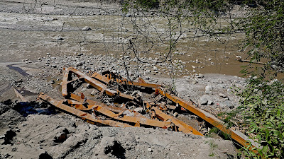
This mangled remains of Indreni bridge has been swept almost 200m downstream by the GLOF
Clean up and excavation operations in progress at Goli Tar, Singtam. As per a panchayat representative, 56 homes were severely damaged by the GLOF here but heeding to the alert from friends and the police, people rushed upto the 'hospital area' - as such there was no loss of life.(Drone image by Praveen)

A severely damaged home at Goli Tar, SIngtam.
At all affected places, we observed a frantic effort by people to get their lives back to normalcy. Heavy machines were continuously dredging out sand, dump trucks ferrying it to the river bank and people tirelessly shoveling out sludge from their homes. Here a temple is being excavated at Goli Tar, Singtam.
Vehicles which were excavated from the river at Goli Tar, Singtam. A person I talked to reported seeing vehicles with headlights 'ON' floating down a wall of water at 3am.
Damaged heavy electrical equipment at Goli Tar, Singtam.
Three weeks after the GLOF of Oct2023, the flood waters had still not dried out in some shops in Lal Bazar, SIngtam. As per a panchayat official, more than 120 houses/shops were severely damaged by the GLOF event in Lal Bazar, while 30 houses were totally washed away by the river.
Literally picking up pieces of their lives, traders in Lal Bazar, salvage whatever they can from their shop which the GLOF engulfed.
Sludge being dug out from heavily populated business areas of Singtam, Sikkim on 29Oct2023
DIkchu NHPC Teesta Stage V dam and Dikchu town (27 23 12.0 N 88 30 18.0 E) Elev: 591.8m

The Teesta Stage V dam at Dikchu is the first major dam after the Sikkim Urja dam (Stage III) at Chungthang (Elevation: 5500')
The Stage V Dikchu dam (elevation 1940') is approx 33km from Chungthang and located in a steep, narrow rocky gorge.NHPC Dikchu Stage V (510 MW) dam on 09Jan2023 (Photo credit: Praveen)
Drone image on 29Oct2023 (Photo credit: Praveen)
Another view of NHPC Dikchu Stage V (510 MW) dam on 27Mar2023 when
we visited Dikchu town to investigate a landslide.
Look carefully and you will notice which structures at the dam site were damaged by the GLOF on 04Oct2023 in the following photos.👇
Blocked tunnels located a short distance downstream from the dam along the river bank.
Teesta river and the Stage V dam at Dikchu on 29Oct2023.
Stage V dam at Dikchu on 29Oct2023.
Stage V dam at Dikchu on 29Oct2023.
The Control Gates on top of the dam which had been opened apparently before the GLOF ; all three had a huge amount of debris strewn all over and around them.
Large tree trunks, sludge and other debris around this structure which is on top of the dam.
Two of the 3 control gates of the dam. All three were open but covered with unimaginable debris and sand.
This appears to be some electrical component of the dam which was severely damaged if not destroyed. It is on top of the dam and visible in our photo of 27Mar2023.
Sludge, tree stumps and roots, damaged or
destroyed components, all on top of the dam, dumped by the Teesta river
as it flowed over the dam for some time during the early morning hours
of 04Oct2023.
Clearly, dams and particularly NHPC took a big hit during the GLOF of 04Oct2023.
Dikchu town (27 24 4.1 N 88 31 12.1 E) Elev: 599.6m
This was the last place we visited on our survey on 29Oct2023.
Here several buildings and homes crumbled under the impact of the surging waters of the Teesta and a school ground and a temple was destroyed below the town. They received messages from their relatives and friends at around 12.30am on 04Oct2023 that 'the river was coming' and again they evacuated in pouring rain to a school located on higher ground and in pitch dark. Several Border Roads Organization personnel who were staying on rented home also lost everything as they moved to safer places at night. Many homes are cracked and unsafe in the town as per locals.
A home which slid down as the river gnawed the base of the hill. This is in the centre of Dikchu town. Do note how precarious it has become for other homes on the edge.
A new building which was still under construction rolled over as the Teesta river eroded the base. The river is still very close to Dikchu town.
A brief note and a reminder
Today, 04Nov2023 is exactly one month since South Lhonak lake, in the high Himalayas burst its banks and caused a GLOF. It was a mammoth and hopefully a rare event where a GLOF triggered a major dam burst which destroyed the lives and livelihoods of so many in our region. The economic cost also has been huge. Unfortunately, neither mainstream media nor our governments thought much of the event, which is another reason for worry - since we are all back to business as usual with highways cracked, parts of towns dangerously weakened, the Teesta flowing at a higher level and closer to many populated areas and so on.
And the next monsoons just 5 months away.
And things are changing on the ground too. After one month of clear, sunny weather (and onset of the festive season), the rivers are mercifully shrinking, the repairs are on, relief centres in Sikkim have been closed and affected people in Sikkim and Kalimpong district are trying to get on with their lives.
With this blog, we have tried to capture quickly all that happened in photographs before everything changes and we forget what was truly a major disaster in the Darjeeling- Sikkim Himalaya. Thus far we have covered only a small part of the affected areas between 27th Mile, Kalimpong district, W Bengal to Dikchu town in Sikkim and even that we have done very cursorily due to time and other constraints.
We will try to cover affected areas upto Chungthang before severe winter sets in.
My thanks to all the affected people who talked to us and we hope our photo essays on this event will help them in some way.
Praful Rao
Kalimpong district
Darjeeling-Sikkim Himalaya
savethehills@gmail.com
with
Praveen Chhetri
Junkeri Studios
9733185815


No comments:
Post a Comment