Showing posts with label Darjeeling-Sikkim. Show all posts

Monday, May 4, 2026

8 Davis AWS stations are available in the Darjeeling Sikkim Himalaya - a brief tutorial on using the AWS.


Kindly refer STH blog of 21Nov2025 on the same subject 

Ever since two Davis Automatic Weather Stations were installed in Kalimpong under Project SHAMROCC in March 2016, I have consistently advocated for expanding the use of automatic weather stations across our region. In the Himalayas, where weather conditions can shift rapidly and the impacts of climate change are especially pronounced, timely and localized data is not a luxury—it is essential. Here, I am glad to inform you that as of now, we have 8 AWS in our vicinity from which updated weather inputs are available 24X7.

Against this backdrop, it is concerning that the extensive AWS network maintained by the India Meteorological Department (IMD), which was previously accessible to the public, has been taken off open access since around March 2025 and now requires login credentials.


AWS can transform how we understand and respond to weather in fragile mountain ecosystems. These systems automatically record and transmit real-time weather data without the need for human intervention.
In the Himalayas, where terrain is rugged and access is limited, AWS are indispensable. They provide continuous, high-accuracy data from remote locations, filling critical gaps left by traditional observation methods. This is especially important as climate change accelerates shifts in weather patterns, glacier melt, and extreme events.
AWS also play a key role in strengthening early warning systems and can help map changing rainfall patterns. 

For those interested in using the global Davis AWS system, here is quick tutorial:

1. Install the Weatherlink Mobile app from Google Playstore. You may have to create an account and register.
2. Open the app and add stations by hitting the + sign in the top left hand corner. Here searching by place names gives satisfactory results 
eg searching for 'Kurseong' will give 'STH KURSEONG NEW' result.
Touch the flag icon on the left to confirm adding the station - it will turn GREEN.
3. In our vicinity, you can add the following 8 stations:
a. Kalimpong - for 'STH AWS' (operated by SaveTheHIlls).
b. Kurseong - for 'STH KURSEONG NEW' (operated by SaveTheHIlls).
c. Ahalay - for 'AHALAY GBN AWS' (operated by Govt of WB, in Gorubathan).
d. Darjeeling - for 'ST PAUL'S SCHOOL METEOROLOGICAL STATION' (operated by SPS, Darjeeling).
e. Pedong - for 'BSA AWS-PEDONG' (operated by Bal Suraksha Abhiyan, Kalimpong).
f. Todey - for 'BSA AWS, TODEY, KALIMPONG' - (operated by Bal Suraksha Abhiyan, Kalimpong) - Todey is located in the eastern most corner of Kalimpong district, close to Bhutan.
g. Gangtok - for 'LAMA BUILDING' (privately operated).
h. Gangtok - for 'SSDMASEEDS' (operated by Sikkim Govt).
4. Your phone display should look something like this👇

Do experiment with the various features which are on the app to receive updated weather information from the DAVIS AWS located in our area as well as all over the world.

Praful Rao
SaveTheHills
savethehills@gmail.com
9475033744


Saturday, November 14, 2020

Tuesday, September 6, 2016

Rainfall data (Darjeeling -Sikkim Himalaya) - August 2016


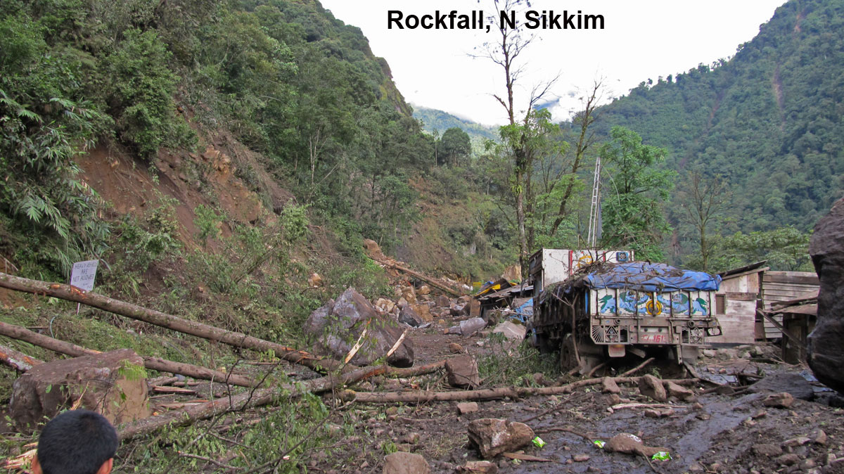
A number of low pressure areas developed in the Bay of Bengal in Aug 2016 but we received little rain from these systems and went deficient in rainfall from the first week till the end of the month. Early in Aug 2016, what has been described as local event dumped 95mm of rain on the Chungthang-Mangan highway at Lantha khola, it caused a major landslide which breached the road.
A photo of the same is placed below.

The major event of the month was the Dzongu landslide of 13Aug2016 which took place in North Sikkim and has been covered in an earlier blog

Praful Rao,
Kalimpong,
Dist Darjeeling

Wednesday, May 13, 2015

The 12May2015 Nepal Quake : An expert's view


Dr Malay Mukul of IIT Mumbai (Dept of Earth Sciences) hails from Kalimpong and has contributed numerous articles to this blog. After yesterday's quakes which rattled much of India, I posed him this question :
'What the hell is happening in our region?'
His reply is placed below :-
_________________________________________
The 12May2015, 7.3 earthquake in eastern Nepal was not completely unexpected. When we had the December 2004, 9.1 Indian Ocean Earthquake, there was similar 8.6 shock in March 2005. There were also two 8+ events in 2007. So once the beast wakes up, it will take its own time to settle down. We can do precious little to change this except either to get out of the way and live in safer places in peninsular India or, if that is not an option, to live in houses that will not kill us during a great earthquake (magnitude 8 and above).
Today's 7.3 earthquake appears to be identical to the 7.8 event. Same fault plane at almost identical depths. The fault that got active is the basal decollement fault of the Himalaya called the Main Himalayan Thrust. This is a fault that is present at the base of the Himalaya and extends from Kashmir to Arunachal Pradesh. Obviously, it is present below us in the Darjeeling-Sikkim Himalaya too.
All the GPS work people have been doing in the Himalaya tells us how much this fault is slipping per year in different parts of the Himalaya. It was about 18 mm/year in the Nepal Himalaya and looks like it is about 16 mm/yr in Darjeeling-Sikkim.
Imagine a beaker filling up with water at this rate. So the question is when will the beaker completely fill up? Once it does, nature empties it out in an event like the Nepal 7.9 earthquake.After that it starts filling up again.
Two scenarios can arise because of this:
1.The 7.9 event also causes a southward lurch of the Himalaya. In the 7.9 event, the Himalaya lurched south by about 4m at 15km depth which was effectively about 1m at the surface. This lurch would also add strain (or water in our example to the beaker that is filling up nearby)to the whole
system. If this sudden addition causes the beaker to fill up in an adjacent region,another event would occur. Strictly speaking it is not an aftershock and a separate event by itself with its own aftershocks.
However, it is an event that is triggered by the main event.
2. The beaker did not empty completely during the 7.9 event. In that case the beaker simply empties itself in two events rather that one. This is definitely better than having a single bigger event. Two 7+ earthquakes are better than one 9 event!
The aftershocks of the 7.9 event showed that the earthquake rupture was propagating east. In fact today's event was very close to the region where we saw a 6.7 aftershock earlier. Would it trigger an event in Darjeeling-Sikkim? It could, if we think the first scenario was operational.
Yes! I totally agree with you, having an earthquake on the decollement or the Main Himalayan Thrust in the Darjeeling-Sikkim Himalaya would be our worst nightmare. We have been very lucky. Nature has given us three warnings!  September 2011 and the 2015 Nepal events.
All projections seem to point to us and say that we could be next. We need to get our act straight! The NIMBY (not in my backyard) syndrome may no longer be applicable to us!
________________________________________________________
Comment by Praful Rao

The writing on the wall is writ large and clear.
Increasingly and every year, disasters in and around the Himalayas (hydrological and geo) are taking a huge toll both in terms of human lives and economic losses. Yet, despite 'the three warnings' Prof Mukul talks about or the recent Kashmir and Uttarakhand disasters I am sure nothing much will change and we will continue our 'normal activities' as if nothing ever happened.

Praful Rao,
Kalimpong,
Dist Darjeeling


Tuesday, September 17, 2013

Remembering the 18Sep2011, 6.8R Earthquake in this region.


A strong earthquake of magnitude M: 6.8 shook Sikkim and Darjeeling areas of India and adjoining Nepal at 18.11 hours IST on 18Sept 2011 with its epicentre near the Sikkim-Nepal border, about 68 km northwest of Gangtok.
Placed above are some images of the region after the earthquake. You can read on the quake here (1, 2, 3)

Photo credit for Sikkim images: Tseten Lepcha 


Praful Rao,
Kalimpong,
Darjeeling district