Showing posts with label storm. Show all posts

Thursday, May 4, 2023

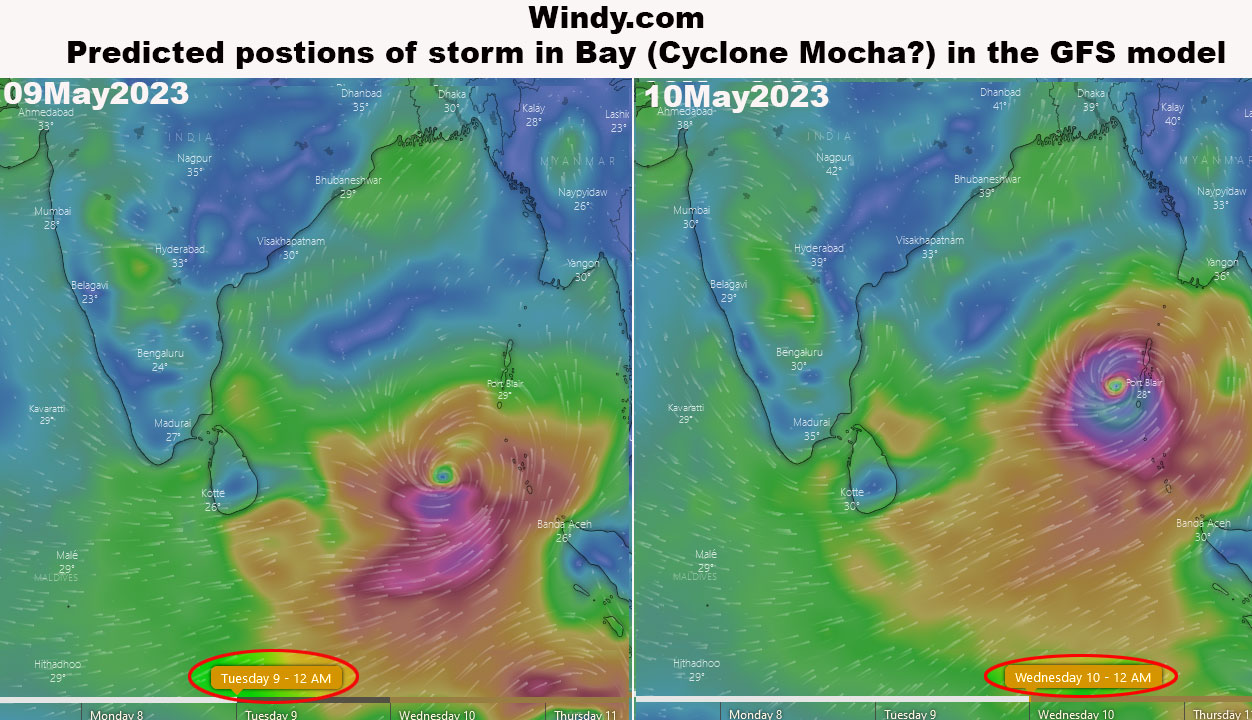
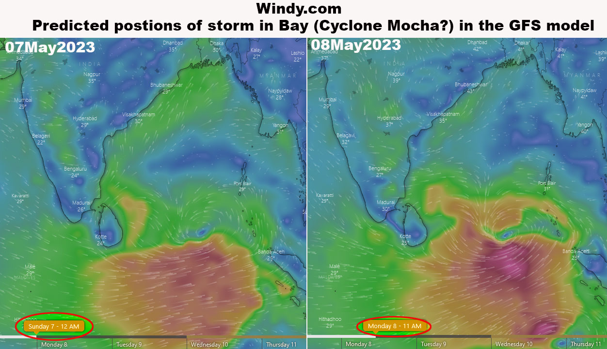
Early Warning: Forecast (GFS Model) positions of storm in the Bay of Bengal from windy.com

The first cyclone of 2023 (Cyclone MOCHA) is expected to form in the Bay of Bengal in a few days.
Forecast positions of the storm (using the GFS model) have been published by windy.com.
Placed below are the forecast positions from the website.


Please check
a. Regional Specialized Meteorological Centre for Tropical Cyclones (https://rsmcnewdelhi.imd.gov.in/rsmc-tropical-cyclones.php)
b. https://mausam.imd.gov.in/responsive/cycloneinformation.php
c. US Navy's Joint Typhoon Warning Centre website (https://www.metoc.navy.mil/jtwc/jtwc.html)
for more accurate forecast track later when the storm forms in the Bay of Bengal

Praful Rao
Kalimpong district
Darjeeling Sikkim Himalaya

Monday, June 1, 2020

STH stormwatch: A cyclone to threaten India's financial hub in the midst of a pandemic

JWTC forecast on the storm in the Arabian sea


Excerpt from IMD forecast
'The Well Marked Low Pressure Area over Southeast & adjoining Eastcentral Arabian Sea and Lakshadweep area concentrated into a Depression over Eastcentral & adjoining Southeast Arabian Sea. and lay centred about 400 km southwest of Panjim (Goa), 700 km south-southwest of Mumbai ( Maharashtra) and 930 km south-southwest of Surat (Gujarat).
It is very likely to intensify into a Deep Depression over Eastcentral & adjoining Southeast Arabian Sea during next 12 hours and intensify further into a Cyclonic Storm over Eastcentral Arabian Sea during the subsequent 24 hours. It is very likely to move nearly northwards initially till 02nd June morning and recurve northnortheastwards and cross north Maharashtra and south Gujarat coasts between Harihareswar (Raigarh, Maharashtra) and Daman during evening/night of 03 rd June,2020.'
 

Like AMPHAN hitting Kolkata on 20May2020, this storm too comes at a time when Mumbai has the highest rate of COVID19 infections in the country and is under lockdown.

UPDATE 1

It is still a Depression but will be called Cyclone 'Nisarga', when it intensifies into a cyclone. It is amazing how two consecutive megastorms (Cyclone 'Amphan' and this one) are targeting two megacities (Kolkata and Mumbai), this one with a population of 20 million and both in the midst of a pandemic.


UPDATE 2


The deep depression has now become a cyclone (NISARGA)  and while the track on the latest RSMC bulletin remains the same as earlier, information on the wind speeds and storm surge is as above.

UPDATE 3

First warning from JTWC has finally been issued.

Update 4


JTWC issued only 4 warnings for Cyclone Nisarga. The fourth and the last is below:
Rainfall records

Nira devghar,Pune dist - 147mm
Panshet,Pune dist - 137mm
Mahabaleswar - 214mm
Koyna Nagar - 156mm
Bhimashankar,Pune dist - 117mm
Khandala - 88mm


Praful Rao
Kalimpong district
Darjeeling-Sikkim Himalaya


Thursday, October 27, 2016

STH stormwatch : Death of Cyclone 'Kyant'

Extract of JTWC statement on Cyclone 'KYANT' :-
' UPPER-LEVEL ANALYSIS SHOWS A POINT SOURCE JUST TO THE EAST OF THE SYSTEM INTRODUCING SOME EASTERLY WIND SHEAR NOT CONDUCIVE FOR REDEVELOPMENT. THE UPPER LEVEL ENVIRONMENT IS EXPECTED TO REMAIN UNFAVORABLE AS THE DEEP-LAYERED RIDE BUILDS ESTABLISHING PREDOMINANT EASTERLY FLOW ALOFT. THE REMNANTS OF TS KYANT IS EXPECTED TO CONTINUE ON A TRACK TO THE WEST-SOUTHWEST ALONG THE SOUTHERN PERIPHERY OF THE BUILDING DEEP-LAYERED RIDGE TO THE NORTHWEST. THIS IS THE FINAL WARNING ON THIS SYSTEM BY THE JOINT TYPHOON WRNCEN PEARL HARBOR HI. THE SYSTEM WILL BE CLOSELY MONITORED FOR SIGNS OF REGENERATION.'

Praful Rao,

Kalimpong,
Dist Darjeeling


Monday, October 24, 2016

STH Stormwatch (24Oct2016) : Storm in bay intensifies into a DEEP depression

Update 1 (25Oct2016) :- Cyclone 'Kyant is born
This is the second cyclone in the Bay in 2016 after Cyclone 'Roanu'

Praful Rao,
Kalimpong
Dist Darjeeling

Saturday, November 7, 2015

STH stormwatch : Low Pressure forms in the Bay of Bengal - 07Nov2015

A Low Pressure Area has formed in the Bay of Bengal and as per IMD, it is likely to intensify into a well marked low pressure and then become a depression in the next 48hrs.

UPDATE on the storm (2100hrs) on 07Nov2015
IMD has upgraded the storm from a 'Low' to a 'Well Marked' low pressure area which will intensify into a depression in the next day or so

 UPDATE on the storm 08Nov2015
Track of storm is from JTWC

UPDATE (2) on the storm 08Nov2015
IMD has upgraded the storm from a 'well marked low' to a 'depression' in their midday weather bulletin. 
For anyone interested to check Chennai weather live see here 

UPDATE on the storm 09Nov2015

UPDATE (2) on the storm 09Nov2015
The depression intensified into a deep depression and crossed north Tamil Nadu coast at
7.30pm

UPDATE (last)  on the storm 10Nov2015 (evening)
The depression has moved inland and has weakened into a low pressure area and lies north of Tamil Nadu.


Praful Rao,
Kalimpong,
Dist Darjeeling

Tuesday, September 15, 2015

STH Stormwatch : The storm in Bay of Bengal Intensifies into a Well Marked Low

Link to JTWC

Update from IMD on 16Sep2015 (evening)

"The well marked low pressure area over south Odisha and neighbourhood has concentrated into a Depression at 1130 hours IST of today, the 16th September over south Odisha & neighbourhood and now lay centred at 1430 hours IST of today near Lat.20.3°N and Long. 83.0°E, about 40kms northwest of Titlagarh and about 160kms southeast of
Raipur. It is likely to move west ­northwestwards during next 24 hours."

Praful Rao,
Kalimpong,
Dist Darjeeling

Friday, May 29, 2015

Extreme Weather Events1 - 'Weather Whiplash' - Texas floods May2015


They call it ‘weather whiplash’- a year of historic floods, fires, tornadoes, snow and ice where weather shifts from one wild extreme to another.
In Wichita Falls, Texas it felt like the drought ended overnight. In just 3 weeks, much of the state had gone from extreme drought to crippling floods. Lakes are fuller than they have been in five years. Scientists say climate change is exacerbating the wild swings.
‘The swings are getting wilder’, says Katherine Hayhoe, Texas Tech Climate Change Researcher ‘Climate change is stretching out our variability’. In the last 30 days, 2.6 trillion gallons of water have filled Texas reservoirs, enough water to serve California for one and a half years. 

- excerpt from nbcnews.com  and time.com

Praful Rao,
Kalimpong,
Dist Darjeeling

Wednesday, August 27, 2014

STH storm watch (27Aug2014) : Low pressure forms in the Bay of Bengal

After a quiescent period stretching almost the entire month of Aug2014, when there was virtually no activity in the Bay of Bengal, IMetD is reporting the formation of a low pressure area in the " west central and adjoining north west Bay of Bengal off north Andhra Pradesh­ south Odisha "
We will post updates as necessary.


Praful Rao,
Kalimpong,
Dist Darjeeling

Sunday, August 3, 2014

STH Stormwatch (03Aug2014) : Another low pressure area in the Bay of Bengal

Excerpt from  IMD's All India Weather Bulletin (Sunday 03Aug2014)
"A low pressure area has formed over north Bay of Bengal and neighbourhood. Associated upper air cyclonic circulation extends upto 7.6 km above mean sea level. It would become well marked low pressure area during next 24 hours"

Updates will be posted as required.

Update on 04Aug2014
"The well marked low pressure area over Gangetic West Bengal and neighbourhood concentrated into a Depression and lay centered at 0830 hours IST of today the 04th August 2014 over Gangetic West Bengal and is close to Midnapur. It would move west­northwesterly direction during next 24 hours and weaken gradually."

Praful Rao,
Kalimpong,
Dist Darjeeling.

Sunday, November 17, 2013

STH stormwatch (17Nov2013) : Last update for depression in Bay of Bengal

The low/depression which we were watching and tracking from the 09Nov2013 has now weakened; as such this our last update for the same.

Praful Rao,
Kalimpong,
Dist Darjeeling

Wednesday, August 21, 2013

STH Stormwatch : "Hurricane" over Darjeeling (19Aug2013) and a persistent storm near Kolkata


August 2013 has seen the development of a number of low pressure areas in the Bay of Bengal, one such low was reported by IMetD on 19Aug2013 and which has since intensified into a depression.
As per IMetD report on 20Aug2013 (evening) the depression was practically stationary south of Kolkata, leading to a nightmare scenario where densely populated regions and ill trained/prepared people living therein are exposed to incessant, heavy rain.
This weather activity in the Bay definitely impacts rainfall over Darjeeling and Sikkim Himalayas which has seen an increase in thundershower activity over this area with moisture laden clouds continuously being pushed in from the Bay - all this happening at the end of the monsoons when the soil is saturated with water.
The "hurricane" of 19Aug2013 which pummeled Darjeeling town is typical of cumulonimbus cloud activity resulting in sharp, heavy downpours with high winds. Known details are as follows :-
a) Time of Occurrence : Approx 2130-2330h IST
b) Max wind speed recorded : 30kmph
c) Rainfall : 40mm
What is dangerous in all this is that Darjeeling district in locked in fierce political turmoil with the W Bengal State and disaster management may well be the last thing on anyone's mind.

Photo Credit : Mohan Lama,
                     The Telegraph.
                     Darjeeling


Praful Rao,
Kalimpong,
Darjeeling district

Friday, March 22, 2013

Reporting an extreme event (21March2013) : More rain in 90mins than the monthly rainfall of March.

Mar - May is technically the pre-monsoon season in India where we do expect thunderstorms associated with Cb activity and in Darjeeling-Sikkim we have been having sporadic rainfall along with thunder and lightning this month.
On 21Mar2013, however, the fast moving western disturbance seen in the IR image above, dumped 37mm of rain and lots of hail in approx 90 mins in Kalimpong.
Considering that the average monthly rainfall (taking data of 5yrs from here) for Darjeeling district for the month of March is 26mm, it seems incredible that yesterday between 3.00-4.30pm  we had more rain than the monthly average rainfall!
My deepest concern and fear in all this is whether we are prepared to face such extreme events which unfortunately becoming more and more frequent.

Praful Rao
Kalimpong