SaveTheHills(STH) is a group of concerned citizens who are raising awareness about landslides in Darjeeling-Sikkim Himalaya. Many landslides are the direct or indirect result of human interference and preventable if sufficient care is taken. As such, unless we begin a comprehensive and sustained program towards landslide management, prevention and mitigation, the consequences of ignoring years of human callousness will, in the future be devastating.
Tuesday, July 21, 2026
Heavy rainfall event: Targeted rainfall over Kalimpong town and its immediate surroundings on 21Jul2026
The type of rainfall Kalimpong witnessed last evening and which continued for the whole of this morning (21Jul2026) was what we expect during the month of July in this region...steady and continuous rain which can turn heavy at times.
There was no thunder or lightning, just the steady drumbeat of heavy rain for hours on end. The graph above shows just that with the rainfall intensity remaining above 50mm/hr for much of the time.
That was not surprising, what was very surprising to me was the fact that the rainfall was very targeted and confined, affecting only Kalimpong town and a small area in its vicinity. The map below reveals this and rainfall figures above 100mm are in RED.Darjeeling received 74.2mm of rain and Kurseong which normally receives the heaviest rain among the hill towns received only 51.4mm. The rainfall figures in black are all below 50mm.
The Infra-Red (IR) cloud imagery (below) of this region of 06.15am today shows nothing which could have caused such heavy rain over Kalimpong while causing only 9.6mm over Siliguri and 8.3mm over Gangtok.
The rainfall caused a small urban landslide near my home in Tirpai Kalimpong this morning. The drone image of the landslide is placed below (27° 4' 37.308" N 88° 29' 17.43" E - drone lat/long). Do notice the densely packed homes which seems to be the direction in which every mountain town in the Himalayas is heading.
Praful Rao
SaveTheHills
savethehills@gmail.com
9475033744
Thursday, July 16, 2026
Urban landslides, the silent killer in our midst...
Having seen countless landslides and talked to hundreds of landslide victims in my almost 20 years of working on this hazard, there is lots to be elated about...much has progressed in the study and mitigation of this earlier underrated hazard.
Yet a common misconception is that a landslide is a massive hill collapsing (which it often is) and thousands dying (rarely happens) and that mitigation of landslides involves lots of complicated engineering which is stupendously costly (which also maybe true).
However, in the midst of all this what we are witnessing with a change of rainfall patterns is that there is a manifold increase in the surface runoff from intense rainfall - simply because there is so much more concrete and asphalt in the mountains today in our urban centers and our drainage system remains abysmal to handle these huge volumes of high velocity water.
So the landslides which have emerged as a big menace in all our mountain urban centres are a human induced smallish slips, which in a densely populated area can kill people.
I am reproducing a report on a landslide which took place in the Kalimpong Municipal area on 13Jul2026:
Landslide Damage Assessment Report
Date of Visit: 15 July 2026
Date of Incident: 13 July 2026
Time of Incident: Approximately 4:30 a.m.
Location of Incident: Ward No. 20, 9th Mile, Kalimpong Municipality, below Rockvale Academy School, Kalimpong
A field visit was conducted to assess the impact of the landslide that occurred on 13 July 2026, understand the condition of the affected households, identify their immediate needs, and observe any continuing risks at the site.
Incident Overview
At approximately 4:30 a.m. on Mon, 13 July 2026, a landslide struck a residential area, affecting two households. One house was completely damaged, while the second sustained partial damage. Fortunately, no casualties or injuries were reported due to the timely response of the affected families and the immediate assistance provided by neighbours and the local community.
Household 1 - Mr. Asta Ratna Bajracharya
Mr. Asta Ratna Bajracharya, aged 60 years, works as a local school transport driver and is the head of a household comprising seven family members. At the time of the incident, however, only Mr. Bajracharya and his 55-year-old wife were present in the house.
According to Mr. Bajracharya, at around 4:30 a.m., they heard an initial loud sound from outside. Assuming it was a tree falling due to the continuous rainfall, they did not immediately suspect any danger. A few moments later, they heard a second, louder sound, which caused them to wake up. As they were getting up, a third and much louder impact occurred when the landslide struck the house.
Mr. Bajracharya explained that the landslide primarily impacted the opposite side of the house from the room where he and his wife were sleeping. This provided them with enough time to react and escape. As the usual exit was no longer accessible, they climbed out through a window. Once outside, they were able to see the extent of the damage caused by the landslide.
The first response was provided by nearby neighbours and members of the local Samaj, who immediately came to assist the couple. Shortly afterwards, personnel from the Fire and Emergency Services arrived at the site. They broke through a section of the damaged wall and assisted in retrieving household belongings that remained trapped inside the house.
The house has been completely damaged and is no longer safe for occupancy. Fortunately, no lives were lost, no livestock was affected, and all-important documents were recovered safely. Mr. Bajracharya and his wife are currently staying in a nearby rented accommodation. They informed that the rental expenses are presently being taken care of through support from the concerned authorities. At present, they do not have any immediate relief needs. Their primary concern is access to a safe and permanent house.
During the discussion, Mr. Bajracharya stated that one of the major contributing factors to the landslide was the poor maintenance of the drainage system. He explained that the drain had frequently become clogged due to indiscriminate dumping of waste. He further shared that he had personally taken the initiative on several occasions to clean the drain and had even installed a signboard requesting people not to dispose of waste in the area. Despite these efforts, waste dumping continued, resulting in blocked drainage and diversion of rainwater towards the slope.
Household 2 - Mr. Sukraj Bajracharya
Mr. Sukraj Bajracharya, aged 86 years, lives with his 81-year-old wife in a household comprising nine family members, including two school-going children. On the day of the incident, seven family members were present in the house.
Mr. Sukraj Bajracharya shared that he usually wakes up early in the morning and was the first to hear the unusual sound outside. Realizing that something was wrong, he immediately alerted the other family members and asked them to move to a safer area of the house. His prompt response ensured that everyone evacuated safely before the situation worsened.
The landslide caused partial damage to the house. Although there was no major structural collapse, a significant amount of mud and debris entered the house, and a portion of the wall had tilted, making the building unsafe for habitation. At the time of the visit, debris was still present inside the house, and some household belongings had yet to be removed.
The family has temporarily shifted to a nearby rented accommodation, where the rental expenses are currently being supported through external assistance. They have also received support from the local Samaj and other individuals. Similar to the first household, they reported no immediate relief needs other than the need for a safe and permanent house.
Mr. Sukraj Bajracharya also expressed the view that poor drainage maintenance and the blockage of drains due to waste accumulation were among the major factors that contributed to the landslide.
Observations
During the site visit, it was observed that the slope above the affected houses remains unstable. Several bamboo clumps on the upper slope were visibly tilted, indicating the possibility of further slope movement if continuous rainfall persists.
Both affected households consistently identified poor drainage maintenance as one of the major contributing factors to the landslide. They stated that drains had frequently become blocked due to indiscriminate waste disposal. In addition, it was observed that construction materials such as stones, pebbles, and aggregates had been stored along sections of the roadside. During periods of heavy rainfall, these materials can obstruct the natural flow of surface runoff, divert water towards vulnerable slopes, and contribute to blockage of drainage channels.
The assessment highlights the importance of regular drain maintenance,
- Report by Stephen Lepcha,
Anugyalaya
Rainfall Data
![]() |
Notice that we had 3 dry days prior to the landslide occurring on 13July morning and also, the rainfall both in the amount (91.6mm) and intensity (instant peak approx 100mm/hr) was not very high.![]() I am glad to report that despite the loss to property no one died in this landslide but this blog is replete with reports of fatal anthropogenic landslides in urban settings and the one which I remember most, is where a mother and her two children lost their lives. It occurred just 5 mins from my home in 2010. |
a. Short term: Manage the water flow; keep our drains clean during the monsoons so that water does not accumulate and cause slope failure. Create quick reaction teams within the community and equip them with power tools to effect a quick rescue.
b. Medium term: During the dry season, repair unstable slopes using bioengineering and other methods so that they are safer during the next monsoons. Repair and enlarge drains and keep our jhoras (natural drains) clean.
c. Long term: Work on raising awareness among the public and govt officials towards creating a safer environment.
My thanks to Stephen for his report and photos.
Praful Rao
SaveTheHills
savethehills@gmail.com
9475033744
Wednesday, May 20, 2026
Using the Automatic Weather Station data to understand weather and rainfall (in this case, of Kalimpong)
a. We had a fairly wet monsoon season (from approx May to Oct2025) characterized by 9 spikes when rainfall exceeded 90mm in a 24hr period. The season did start with some hiccups though:
Typical cloud image over North Bengal and Sikkim before the heavy rain of 19Jun2025Warning on 13Jul2025 for the heavy rain (112.8mm) on 14Jul2025.July is typically the wettest month of the monsoon season. In July 2025, there were four days during which rainfall exceeded 90 mm in a 24-hour period. Thereafter, rainfall gradually declined, apart from a brief spike on 12 August 2025. Total rainfall amounted to 467 mm in August and 253.2 mm in September 2025.
October 2025 was relatively dry, except for two days of intense rainfall. On 4–5 October, widespread heavy rain affected the entire region and triggered devastating landslides and flash floods, resulting in significant loss of life in Mirik.
These instances of spikes in rainfall are normally associated with convective clouds and normally consist of short, violent bursts of rainfall which cause high runoff and low infiltration of water (as such no recharge of aquifers) and only result in soil erosion, landslides and damage to roads.Praful Rao
SaveTheHills
savethehills@gmail.com
9475033744
Monday, October 27, 2025
Extreme rainfall event in the Darjeeling district: 04/05Oct2025 (Part IIIB - damage caused by 'non- fatal landslides')
Non - fatal landslides
Seeyok Tea Garden - Sukhia block.
c. Damage: 7 homes completely damaged, 3 partially damaged. Livestock has been lost and vegetable gardens are ruined. Roads in the area are in a mess. 32 people were living in a relief camp. Many vehicles and two wheelers belonging to the community were washed away.
no one died - in large part due to the alertness of the community and timely evacuation to safer ground.
Taba Koshi, Mirik Subdivision (Coords 26.921391N 88.173500E)
On 04Oct2025, due to the festive season, almost all the homestays were full with tourists from the plains.
b. Circumstances: As in other areas, rainfall started during the day on 04Oct2025 but intensified after 6pm and became really heavy later. Noticing the Rangbangh river had started crossed all danger levels, the locals started evacuating their guests to safer places after midnight. The power supply which had been erratic, thru the day because of the intense lightning on 04Oct2025 went OFF altogether at night so everything had to be done in pitch darkness and in heavy rain. So it was nothing short of a miracle that no one died.
Report by STH Survey team (which will be updated as and when possible)
From Left to RightSteve Rai(interviews and videos with Praveen)
Yukta Acharya (Interviews and records): yuktaa1999@gmail.com
Shreya Gurung (Interviews): shreyagurung07@gmail.com
Praveen Chhetri (all drone images and photographs): junkeristudio@gmail.com
with sincere thanks and appreciation to Roshan, Rajen bhai and Priya of Darjeeling Himalaya Initiative (DHI)
and also to Aachal (Anugyalaya DDSSS) for helping with resource persons and information.
Praful Rao
savethehills@gmail.com
9475033744
Sunday, October 5, 2025
Extreme rainfall event in the Darjeeling-Sikkim Himalayas: 04/05Oct20205 (Part I - 'The Rainfall')
Thus far, in the SW monsoons of 2025 our region saw a deficiency of rainfall:
Sept2025 was especially dry in Kalimpong and with the monsoons expected to exit our region on 10Oct2025, one did not expect a major rainfall event.What has been happening, however is that the Bay of Bengal has been inordinately active with bumper to bumper low pressure areas forming and many of them, after moving over land in a north westerly direction reaching as far as Rajasthan leading to excess rain in a normally arid area.
Origin of the extreme rainfall event.
Around the 29Sep2025, I posted a notice in our What's App group 'Hazard Alerts or HA' stating a LOW was expected (by IMD) in the Bay on 01Oct2025:
The LOW pressure formed as forecast and quickly intensified into a depression by 02Oct2025The above image was posted in our Whats App group (HA) on 02Oct2025,showing location of the depression, the forecast track and warnings issued by IMD. An update to the forecast track of the 'deep depression' now showed the storm moving in a 'nearly northward direction' instead of the normally NW direction.As forecast, the storm (now a well marked LOW) on 03Oct2025, reached parts of east UP (see below) and was almost stationery there until 04Oct2025.The storm finally started moving as predicted in a NNE direction, heading directly towards Bihar, SHWB (Sub Himalayan W Bengal) and Sikkim at approx 3pm on 04Oct2025 (yesterday), below:

In the top image, do note the density of lightning strikes which were taking place.
Rainfall data
03Oct2025: Despite having a RED warning for heavy rain, our
entire region received very little rain. I distinctly recollect that in
Kalimpong (my home), it was a densely overcast day which turned stormy around
midday but except for some drizzle, there was no precipitation.
04Oct2025: I was monitoring the Davis Automatic Weather stations in our area and
we had light rain from around midday. At Kalimpong, it started thundering
in the late evening and by 7.30pm, the thunder had intensified. Thereafter, the
rainfall, lightning and thunder continued thru the night with little or no
break
windy.com image of 11pm/04Oct, just when lightning and rain was increasing over our area. The storm had moved from its earlier location and was approaching us from the SW.
Rainfall Intensity at KalimpongThe above graph showing the rainfall intensity at Kalimpong on 04Oct2025, also shows the duration of the rainfall. Peak intensity of rainfall almost hit 150mm/hr and almost the entire 158mm of rain came down between 8pm and 4am ie 8hrs.Lightning strikes at 3.30am/05Oct2025. The storm exited our area and continued NE wards about an hour later having killed 23 people.Rainfall readout from our Davis AWS at Kurseong at 4.13am on 05Oct2025 (today). Kurseong is known to have heavy rainfall and has some very large landslides there. The rainfall from the extreme event was 393mm.
Praful Rao
SaveTheHills
savethehills@gmail.com
9475033744
We will cover the casualties as well as the damage done by one day's rainfall on 04/05Oct2025 in Part II to this post.
windy.com image of 11pm/04Oct, just when lightning and rain was increasing over our area. The storm had moved from its earlier location and was approaching us from the SW.Saturday, March 22, 2025
Updated satellite images of Oct 2023 GLOF affected areas from Google Earth
Google Earth has recently (Jan2025) made available high resolution images of some areas of North Sikkim which reveal the devastating impact of the Glacial Lake Outburst Flood (GLOF) of Oct2023 in North Sikkim. The images below juxtapose the affected areas with historical snapshots, illustrating the catastrophic consequences of the GLOF.
Chungthang town / confluence of the Lachen and Lachung Chu
On October 3, 2023, an avalanche triggered a GLOF in South Lhonak glacial lake (elevation 5200m/17000'), approximately 75km upstream from Chungthang along the Lachen Chu. The resulting sudden release of around 50 million cubic meters of water made it the largest GLOF in the Himalayas in recent history.
For a detailed account of this event, refer to this publication in Science magazine
STH has closely documented the Teesta valley GLOF of Oct2023 in this blog from the date of occurrence.
Satellite images along with photos of the affected areas are placed below:-
Chungthang town (close up)
![]() |
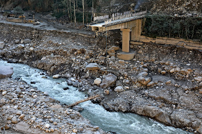
| Chungthang town (Dec2024) The still devastated playground and army camp area is seen at the center with the gilded dome of the Gurudwara towards the right side.Chungthang town playground on 19Nov2023 when we visited the area. The 1200mw Sikkim - Urja dam and bridge at Chungthang This was the largest dam in Sikkim and was located downstream of the confluence of the Lachen and Lachung Chu rivers. The 60m rockfill, run of the river dam was commissioned in Feb 20217 at a cost of Rs 14,000crores. Along with the dam, a major bridge (centre top of photo) connecting Chungthang to the rest of Sikkim was also destroyed by the GLOF. The remnants of Sikkim Urja dam which collapsed in the GLOF on 04Oct2023. Photographed on 18Nov2023, when we visited Chungthang.A double laned concrete bridge connecting Chungthang to the rest of Sikkim was destroyed by the GLOF here on 04Oct2023Munshithang (27.6324° N 88.6157° E) Munshithang, an ammo depot for the Indian army was totally destroyed by the 04Oct Teesta Valley GLOF. On receiving warning of the rising waters in the Lachen Chu, 92 personnel of the ammo depot moved to higher ground and thus their lives were saved. However, it was 4 days before they could be evacuated - due to bad weather which prevented helicopter flights. Nothing could be retrieved of the ammunition and equipment lost to the GLOF. Toong bridge over the Teesta river (27°33'0.15"N 88°38'35.17"E) ![]() We visited this area on 19Nov2023 and photographed the bridge and the Toong checkpost both of which were destroyed by the GLOF (below) ![]() There was only a small bamboo bridge across the Teesta for pedestrians to cross the river on foot in Nov2023The Toong police checkpost had been vacated and dangled precariously from the edge of the roadAnother view of the vacated police checkpost in Nov2023Faced with the sheer necessity of communicating, the local community start constructing a wooden bridge across the Teesta at Toong. Naga Gram Panchayat (Mangan district, North Sikkim) Naga GP is located approx 14km from Mangan (district HQ of N Sikkim district) towards Toong and was one of the worst affected areas when we visited Chungthang on 19Nov2023. It continues to be a wrecked and desolate place as can be seen from the recent photos (of Dec2024) below (photo credits: Rinchen Lama, IIHS ,Bangalore) |