Showing posts with label low pressure area. Show all posts

Sunday, October 5, 2025

Extreme rainfall event in the Darjeeling-Sikkim Himalayas: 04/05Oct20205 (Part I - 'The Rainfall')

 Thus far, in the SW monsoons of 2025 our region saw a deficiency of rainfall:

Sept2025 was especially dry in Kalimpong and with the monsoons expected to exit our region on 10Oct2025, one did not expect a major rainfall event.
What has been happening, however is that the Bay of Bengal has been inordinately active with bumper to bumper low pressure areas forming and many of them, after moving over land in a north westerly direction reaching as far as Rajasthan leading to excess rain in a normally arid area.

Origin of the extreme rainfall event.
Around the 29Sep2025, I posted a notice in our What's App group 'Hazard Alerts  or HA' stating a LOW was expected (by IMD) in the Bay on 01Oct2025:

The LOW pressure formed as forecast and quickly intensified into a depression by 02Oct2025
The above image was posted in our Whats App group (HA) on 02Oct2025,showing location of the depression, the forecast track and warnings issued by IMD.
An update to the forecast track of the 'deep depression' now showed the storm moving in a 'nearly northward direction' instead of the normally NW direction.
As forecast, the storm (now a well marked LOW) on 03Oct2025, reached parts of east UP (see below) and was almost stationery there until 04Oct2025.
The storm finally started moving as predicted in a NNE direction, heading directly towards Bihar, SHWB (Sub Himalayan W Bengal) and Sikkim at approx 3pm on 04Oct2025 (yesterday), below:

In the top image, do note the density of lightning strikes which were taking place.

Rainfall data
03Oct2025: Despite having a RED warning for heavy rain, our entire region received very little rain. I distinctly recollect that in Kalimpong (my home), it was a densely overcast day which turned stormy around midday but except for some drizzle, there was no precipitation.

 04Oct2025: I was monitoring the Davis Automatic Weather stations in our area and we had light rain from  around midday. At Kalimpong, it started thundering in the late evening and by 7.30pm, the thunder had intensified. Thereafter, the rainfall, lightning and thunder continued thru the night with little or no break
windy.com image of 11pm/04Oct, just when lightning and rain was increasing over our area. The storm had moved from its earlier location and was approaching us from the SW.

Rainfall Intensity at Kalimpong
The above graph showing the rainfall intensity at Kalimpong on 04Oct2025, also shows the duration of the rainfall. Peak intensity of rainfall almost hit 150mm/hr and almost the entire 158mm of rain came down between 8pm and 4am ie 8hrs.
Lightning strikes at 3.30am/05Oct2025. The storm exited our area and continued NE wards about an hour later having killed 23 people.
Rainfall readout from our Davis AWS at Kurseong at 4.13am on 05Oct2025 (today). Kurseong is known to have heavy rainfall and has some very large landslides there. The rainfall from the extreme event was 393mm.

Praful Rao
SaveTheHills
savethehills@gmail.com
9475033744

We will cover the casualties as well as the damage done by one day's rainfall on 04/05Oct2025 in Part II to this post.

Saturday, October 21, 2023

STH stormwatch : LOW pressure in the Bay of Bengal.

SaveTheHills Stormwatch is a series where we track and report on significant weather developments in our region not only to forewarn our communities (which we largely do today through our WhatsApp Group 'Hazard Alerts 1& 2') but keep a record of the event.
As on 20Oct2023, a low pressure formed in the central Bay of Bengal which is likely to intensify into a depression by 22Oct and move towards the Bangladesh and West Bengal coasts by 24Oct2023.
The Darjeeling-Sikkim region has just seen catastrophic flooding and destruction in the 04Oct2023 GLOF from South Lhonak glacier and being located barely 600kms from the Bay of Bengal any major storm in the north Bay will probably impact our region and which would hamper all reconstruction activities and make lives of those who have lost everything even more difficult.

Update on 22Oct2023

IMD has posted to its first forecast track (above) on the probable path of the storm

Update 24Oct2023: Cyclone 'HAMOON' is born
JTWC's forecast track
IMD latest forecast track

Kolkata reported moderate rainfall for sometime on 23Oct2023, but largely the storm seems to be keeping clear of the city.


Praful Rao
Kalimpong district
Darjeeling-Sikkim Himalaya
savethehills@gmail.com
9475033744

Friday, April 14, 2017

STH Stormwatch : The FIRST storm of 2017 (in the Bay of Bengal)

Location of Low pressure area is approximate

Update from JTWC  (1330h / 14Apr2017)
JTWC has upgraded the warning from LOW to MEDIUM and extract is reproduced below :-
'GLOBAL MODELS ARE IN AGREEMENT ABOUT THE SYSTEM CONTINUING TO DEVELOP RAPIDLY AND TRACK TO THE NORTH-NORTHEAST. MAXIMUM SUSTAINED SURFACE WINDS ARE ESTIMATED AT 20 TO 25 KNOTS. MINIMUM SEA LEVEL PRESSURE IS ESTIMATED TO BE NEAR 1005 MB. THE POTENTIAL FOR THE DEVELOPMENT OF A SIGNIFICANT TROPICAL CYCLONE WITHIN THE NEXT 24 HOURS IS UPGRADED TO MEDIUM.'

Update of 15Apr2017 (JTWC)

Update of 15Apr2017 (IMD)IMD has categorized the storm as a DEPRESSION now (morning inference) and forecasts the storm to intensify further into a deep depression and move towards the north Myanmar coast in the next 72hrs


Praful Rao
Kalimpong district,
Darjeeling-Sikkim Himalaya

Monday, December 5, 2016

Tuesday, November 1, 2016

STH Stormwatch : Low Pressure in Bay of Bengal (01Nov2016) and update (04Nov2016)


The system has intensified into a depression and is expected eventually become a cyclone.

Praful Rao
Kalimpong,
Dist Darjeeling

Friday, December 4, 2015

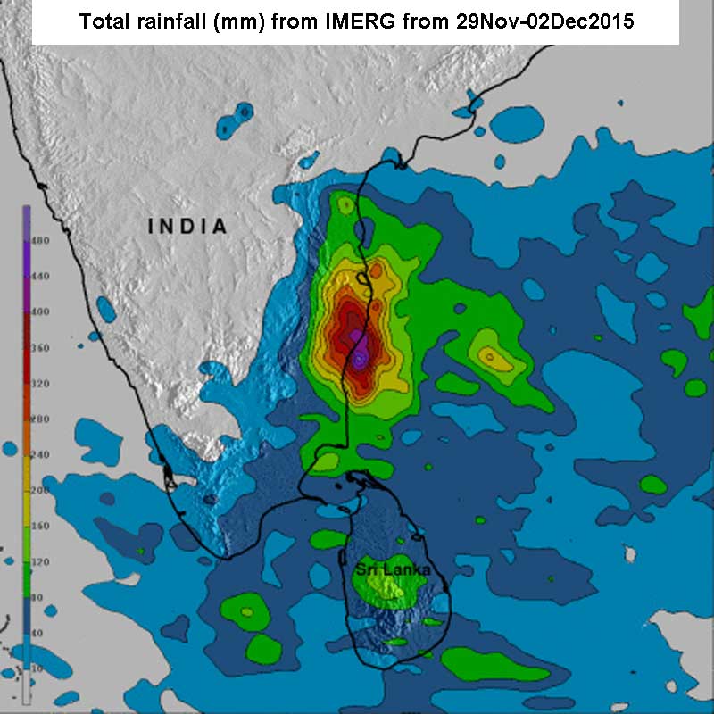
Tamil Nadu rainfall (updated 05Dec2015) : Maps from IMERG and a video


Excerpts from IMERG (09-16Nov2015)

Rainfall : upto 550mm along south eastern coast
Fatalities : 71 (59 in Chennai)


Excerpts from IMERG (29Nov-02Dec2015)
Rainfall : over 400mm
Fatalities : 188

Total Rainfall since 01Oct2015 : 1556mm (BBC)
Death toll till date : 280 (BBC)


Praful Rao,
Kalimpong,
Dist Darjeeling


Saturday, November 7, 2015

STH stormwatch : Low Pressure forms in the Bay of Bengal - 07Nov2015

A Low Pressure Area has formed in the Bay of Bengal and as per IMD, it is likely to intensify into a well marked low pressure and then become a depression in the next 48hrs.

UPDATE on the storm (2100hrs) on 07Nov2015
IMD has upgraded the storm from a 'Low' to a 'Well Marked' low pressure area which will intensify into a depression in the next day or so

 UPDATE on the storm 08Nov2015
Track of storm is from JTWC

UPDATE (2) on the storm 08Nov2015
IMD has upgraded the storm from a 'well marked low' to a 'depression' in their midday weather bulletin. 
For anyone interested to check Chennai weather live see here 

UPDATE on the storm 09Nov2015

UPDATE (2) on the storm 09Nov2015
The depression intensified into a deep depression and crossed north Tamil Nadu coast at
7.30pm

UPDATE (last)  on the storm 10Nov2015 (evening)
The depression has moved inland and has weakened into a low pressure area and lies north of Tamil Nadu.


Praful Rao,
Kalimpong,
Dist Darjeeling

Saturday, September 12, 2015

STH stormwatch : Reporting a low pressure area in the Bay of Bengal (12Sep2015)


Excerpt from the Midday All India Weather Inference of IMD of 12Sep2015

'Under the influence of the upper air cyclonic circulation over west central Bay of Bengal, a low pressure area has formed over west central and adjoining northwest Bay of Bengal.'

Praful Rao,
Kalimpong,
Darjeeling

Wednesday, July 8, 2015

STH stormwatch : Low pressure area forms in the north Bay of Bengal.


"Under the influence, the cyclonic circulation over north Bay of Bengal and  neighbourhood, a low pressure area has formed over north Bay of Bengal and  adjoining coastal areas of Bangladesh and West Bengal"
- Excerpt from the IMD  'All India Weather Summary'.

Praful Rao,
Kalimpong,
Dist Darjeeling

Wednesday, August 27, 2014

STH storm watch (27Aug2014) : Low pressure forms in the Bay of Bengal

After a quiescent period stretching almost the entire month of Aug2014, when there was virtually no activity in the Bay of Bengal, IMetD is reporting the formation of a low pressure area in the " west central and adjoining north west Bay of Bengal off north Andhra Pradesh­ south Odisha "
We will post updates as necessary.


Praful Rao,
Kalimpong,
Dist Darjeeling

Sunday, August 3, 2014

STH Stormwatch (03Aug2014) : Another low pressure area in the Bay of Bengal

Excerpt from  IMD's All India Weather Bulletin (Sunday 03Aug2014)
"A low pressure area has formed over north Bay of Bengal and neighbourhood. Associated upper air cyclonic circulation extends upto 7.6 km above mean sea level. It would become well marked low pressure area during next 24 hours"

Updates will be posted as required.

Update on 04Aug2014
"The well marked low pressure area over Gangetic West Bengal and neighbourhood concentrated into a Depression and lay centered at 0830 hours IST of today the 04th August 2014 over Gangetic West Bengal and is close to Midnapur. It would move west­northwesterly direction during next 24 hours and weaken gradually."

Praful Rao,
Kalimpong,
Dist Darjeeling.

Monday, July 28, 2014

From the Telegraph today

From 'The Telegraph' today.

Weather data show that the shortage of rain is as high as 800mm at some places in the region compared to previous year’s figures.
While Jalpaiguri received 2,170mm rain from January 1 to July 25 in 2013, this year’s recording for the same period was 1,881mm, a shortage of 289mm.
The difference in the rainfall in Alipurduar is 835mm with the town receiving 2,238mm from January to July 25, 2013, and 1,403mm this year. The figures for the same period in 2013 and 2014 in Banarhat are 3,481mm and 2,645mm, respectively.
Since the last 15 days, Siliguri and Jalpaiguri have not got heavy rainfall. 

Read full article here

STH stormwatch 
IMetD is reporting a low pressure in the northwest Bay of Bengal which is expected to move in a northwesterly direction.
We are keeping a watch.

Praful Rao,
Kalimpong
Dist Darjeeling

Sunday, November 17, 2013

STH stormwatch (17Nov2013) : Last update for depression in Bay of Bengal

The low/depression which we were watching and tracking from the 09Nov2013 has now weakened; as such this our last update for the same.

Praful Rao,
Kalimpong,
Dist Darjeeling

Wednesday, November 13, 2013

STH stormwatch (13Nov2013) update : The storm intensifies into a depression

STH has been watching this system since the 09Nov2013 and the latest update is placed below:-

"The well marked low pressure area over southeast Bay of Bengal and neighbourhood has concentrated into a depression and lies over southwest  and adjoining southeast Bay of Bengal, lay centred at 0530 hours IST near latitude 11.5 °N and longitude 86.5°E, about 700 km east­ southeast of Chennai.
The depression over southwest and adjoining southeast Bay of Bengal would move west­ north westwards and intensify into a deep depression during next 48 hours." - IMetD


Praful Rao,
Kalimpong,
Dist Darjeeling

Saturday, November 9, 2013

STH stormwatch (09Nov2013) : Low pressure over Andaman Sea

2013 seems to be ending with a bang, what with a low pressure brewing up in the Andaman sea in early Oct and mutating  into  Very Severe Cyclone Phailin within a week and  with Super Typhoon Haiyan literally obliterating parts of Philippines yesterday.
IMetD is now reporting another low pressure in the Andaman sea which it cautions will intensify into a well-marked low pressure area within 24 hrs - that is exactly what happened with Phailin.

Praful Rao,
Kalimpong,
Dist Darjeeling.