Showing posts with label Tamil Nadu. Show all posts

Saturday, November 30, 2024

ALL ABOUT CYCLONES: How cyclone track forecasts can change dramatically and how climate change maybe impacting them.

 We have been tracking the storm in the Bay of Bengal for several days now (as we normally do) and have been posting updates in our WhatsApp Group 'Hazard Alerts'.
On 26Nov2024, the forecast from IMD clearly said that the storm would intensify into a CYCLONE

This was changed and on 28Nov and the storm was expected to remain a 'DEEP DEPRESSION' and make landfall on 30Nov2024 as a 'WELL MARKED LOW' (see below)
The forecast was revised the next day and the track showed the storm intensifying into CYCLONE 'FENGAL'on 29Nov2024.
The latest forecast track from IMD of 'FENGAL' together with WARNING no '3' from JTWC is reproduced below.
The tracks from IMD and JTWC seem to coincide.
I am also posting an article from today's Statesman on how climate change maybe impacting cyclones in the Bay of Bengal
Praful Rao
SaveTheHills
savethehills@gmail.com
9475033744

Wednesday, November 30, 2016

STH Stormwatch : Cyclone 'NADA' brews up in the Bay of Bengal (30Nov2016)

Cyclone 'NADA' has  formed in the Bay of Bengal and is expected to make landfall in Tamil Nadu in the early hours of the morning on 02Dec2016.
Thus far in 2016, we have had 3 Cyclones forming in the Bay of Bengal - Roanu, Kyant and now Cyclone NADA

Praful Rao.
Kalimpong,
Dist Darjeeling

Friday, December 4, 2015

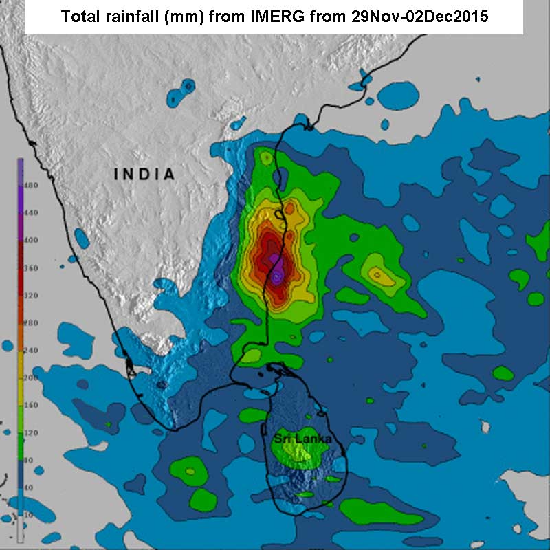
Tamil Nadu rainfall (updated 05Dec2015) : Maps from IMERG and a video


Excerpts from IMERG (09-16Nov2015)

Rainfall : upto 550mm along south eastern coast
Fatalities : 71 (59 in Chennai)


Excerpts from IMERG (29Nov-02Dec2015)
Rainfall : over 400mm
Fatalities : 188

Total Rainfall since 01Oct2015 : 1556mm (BBC)
Death toll till date : 280 (BBC)


Praful Rao,
Kalimpong,
Dist Darjeeling


Wednesday, December 2, 2015

If this isn't a wake up call, what is? - Chennai (Meenambakam) airport on 02Dec2015

The image above shows aircraft on flooded tarmacs of Meenambakam Airport at Chennai on 02Dec2015.
STH has been monitoring and reporting the storms associated with the NE monsoons in the southern peninsular (see1, 2 and 3) and it is high time we start expecting the unexpected.


Praful Rao,
Kalimpong,
Dist Darjeeling

Saturday, November 7, 2015

STH stormwatch : Low Pressure forms in the Bay of Bengal - 07Nov2015

A Low Pressure Area has formed in the Bay of Bengal and as per IMD, it is likely to intensify into a well marked low pressure and then become a depression in the next 48hrs.

UPDATE on the storm (2100hrs) on 07Nov2015
IMD has upgraded the storm from a 'Low' to a 'Well Marked' low pressure area which will intensify into a depression in the next day or so

 UPDATE on the storm 08Nov2015
Track of storm is from JTWC

UPDATE (2) on the storm 08Nov2015
IMD has upgraded the storm from a 'well marked low' to a 'depression' in their midday weather bulletin. 
For anyone interested to check Chennai weather live see here 

UPDATE on the storm 09Nov2015

UPDATE (2) on the storm 09Nov2015
The depression intensified into a deep depression and crossed north Tamil Nadu coast at
7.30pm

UPDATE (last)  on the storm 10Nov2015 (evening)
The depression has moved inland and has weakened into a low pressure area and lies north of Tamil Nadu.


Praful Rao,
Kalimpong,
Dist Darjeeling

Monday, December 9, 2013

STH stormwatch (Cyclone 'MADI' update) : New forecast tracks from JTWC for 'MADI'

JTWC has updated its forecast track of Very Severe Cyclone 'MADI', which now is expected to recurve on a south south westerly course and head towards Tamil Nadu, weakening as it does so.
Landfall is expected around 13Dec2013.


Praful Rao,
Kalimpong,
Dist Darjeeling