Showing posts with label IMD. Show all posts

Sunday, October 5, 2025

Extreme rainfall event in the Darjeeling-Sikkim Himalayas: 04/05Oct20205 (Part I - 'The Rainfall')

 Thus far, in the SW monsoons of 2025 our region saw a deficiency of rainfall:

Sept2025 was especially dry in Kalimpong and with the monsoons expected to exit our region on 10Oct2025, one did not expect a major rainfall event.
What has been happening, however is that the Bay of Bengal has been inordinately active with bumper to bumper low pressure areas forming and many of them, after moving over land in a north westerly direction reaching as far as Rajasthan leading to excess rain in a normally arid area.

Origin of the extreme rainfall event.
Around the 29Sep2025, I posted a notice in our What's App group 'Hazard Alerts  or HA' stating a LOW was expected (by IMD) in the Bay on 01Oct2025:

The LOW pressure formed as forecast and quickly intensified into a depression by 02Oct2025
The above image was posted in our Whats App group (HA) on 02Oct2025,showing location of the depression, the forecast track and warnings issued by IMD.
An update to the forecast track of the 'deep depression' now showed the storm moving in a 'nearly northward direction' instead of the normally NW direction.
As forecast, the storm (now a well marked LOW) on 03Oct2025, reached parts of east UP (see below) and was almost stationery there until 04Oct2025.
The storm finally started moving as predicted in a NNE direction, heading directly towards Bihar, SHWB (Sub Himalayan W Bengal) and Sikkim at approx 3pm on 04Oct2025 (yesterday), below:

In the top image, do note the density of lightning strikes which were taking place.

Rainfall data
03Oct2025: Despite having a RED warning for heavy rain, our entire region received very little rain. I distinctly recollect that in Kalimpong (my home), it was a densely overcast day which turned stormy around midday but except for some drizzle, there was no precipitation.

 04Oct2025: I was monitoring the Davis Automatic Weather stations in our area and we had light rain from  around midday. At Kalimpong, it started thundering in the late evening and by 7.30pm, the thunder had intensified. Thereafter, the rainfall, lightning and thunder continued thru the night with little or no break
windy.com image of 11pm/04Oct, just when lightning and rain was increasing over our area. The storm had moved from its earlier location and was approaching us from the SW.

Rainfall Intensity at Kalimpong
The above graph showing the rainfall intensity at Kalimpong on 04Oct2025, also shows the duration of the rainfall. Peak intensity of rainfall almost hit 150mm/hr and almost the entire 158mm of rain came down between 8pm and 4am ie 8hrs.
Lightning strikes at 3.30am/05Oct2025. The storm exited our area and continued NE wards about an hour later having killed 23 people.
Rainfall readout from our Davis AWS at Kurseong at 4.13am on 05Oct2025 (today). Kurseong is known to have heavy rainfall and has some very large landslides there. The rainfall from the extreme event was 393mm.

Praful Rao
SaveTheHills
savethehills@gmail.com
9475033744

We will cover the casualties as well as the damage done by one day's rainfall on 04/05Oct2025 in Part II to this post.

Sunday, August 10, 2025

About Early Warning Devices viz Doppler Weather Radars (DWRs) and Automatic Weather Stations (AWS)


Below is an article from today’s The Statesman that underscores many of the key issues we at 'SaveTheHills' (STH) have been tirelessly raising, writing about, and advocating for over many years:

The information about DWRs which I have been able to garner from the internet is as under:
As per the above information there are 10 DWRs in the Western Himalayas (RED dots) and ONLY 3 DWRs in the Eastern region (GREEN dots). In this connection, there maybe some conventional (non DWR) older type weather radars about which I could not get information. These will be replaced by DWRs by 2026.
The above information is reproduced below in a map form:
Many years ago, I attended an IMD workshop at Baluatar in Gangtok, where I raised the need of a DWR in the Darjeeling-Sikkim Himalayas. I was told that then that a DWR had been earmarked for Sikkim by IMD but as can be seen nothing materialized over the years and now a DWR is being installed in Malda (W Bengal) which will certainly give adequate inputs/warning for North Bengal but may not be effective for the mountainous regions because of signal loss and shadowing.
In this regard, Nepal has 3 weather radars but I could not locate their data and Bhutan has none.
About IMD Automatic Weather Station website
I have already partly covered this in my blog of yesterday but if you try and access the IMD AWS site (http://aws.imd.gov.in:8091/internal/login.php) today, you will be greeted with this sign
Whereas just a few months ago, the IMD AWS information for the whole country was freely available for anyone, now it is 'internal information' only available to IMD or government officials.
Each state has a separate password to gain access to weather data of the state.

With the inputs which I have given you, please read 'The Statesman' article again and wonder which direction our early warning systems for the mountains are pointing.

Praful Rao
SaveTheHills
savethehills@gmail.com
9475033744

Wednesday, May 8, 2024

Normal Rainfall stats for Sub-Himalayan West Bengal (SHWB) and Sikkim updated by IMD Gangtok.

 The Rainfall Normals for SHWB and Sikkim have been revised by IMD. The OLD one (below)

has been updated and the NEW Rainfall Normals are placed here:

Significant points to note are:

  • The period of observation has decreased from 1951 to 1971 to 2000 ie a 20 year decline.
  • There is an overall decrease in the TOTAL rainfall by 169.1mm ie from 2708.9mm to 2539.8mm
  • There is a significant decrease (325.5mm) in the rainfall for the winter and pre-monsoon periods so we will have more drought like conditions during this period.
  • There is a significant increase (254.9mm) in the rainfall for the post monsoon period.
  • Rainfall during the monsoon period has also decreased by 116.7mm. 

Source: IMD Gangtok (Sikkim)


Praful Rao
Kalimpong district
Darjeeling-Sikkim Himalaya
savethehills@gmail.com
9475033744


Tuesday, August 1, 2023

STH Storm Watch: Tropical Cyclone 04B in the north Bay of Bengal (01Aug2023)


 Whereas JTWC has issued Warning No 2 for 'Tropical Cyclone 04B (with tracks)' in the north Bay of Bengal, IMD still categorizes the storm as a 'deep depression' and the track is shown below:
In the morning, only an 'Orange' warning for heavy rain had been issued for S Bengal which has been upgraded at around 10.30hrs to RED warning for some areas of S Bengal and Odisha.

Updated track of the storm at 2pm/01Aug2023


Hope the storm intensity and rainfall remains within manageable limits, because the projected track passes over densely populated areas of S Bengal.

Praful Rao
Kalimpong district
Darjeeling-Sikkim Himalaya
savethehills@gmail.com
9475033744


Tuesday, March 1, 2022

Rainfall data of Feb2022 of some towns in the Darjeeling- Sikkim Himalaya


Praful Rao
Kalimpong district
Darjeeling - Sikkim Himalaya

Wednesday, May 20, 2020

Super Cyclone Amphan makes landfall in the vicinity of Kolkata: 20May2020 (1430hrs onwards)

Source:https://en.allmetsat.com/metar-taf/india-nepal-bhutan-bangladesh-burma.php?icao=VECC

Tracking the Beast

Was declared a Cyclonic Storm 'Amphan' on 16May2020, after which it rapidly intensified in Severe Cyclone. STH posted continuous updates on the tracks of the storm

RSMC, Delhi and JTWC issued some 33 advisory bulletins and 18 warnings respectively from 15May until the storm made landfall exactly as predicted on 20May near Kolkata
First track forecast and the final track observed are placed below:
Rainfall

Fact Sheet:
·        * Landfall process started at around 1430hrs/20May2020 between Digha and Hadia islands as predicted and passed thru the Sunderbans between 1530hrs to 1730hrs.
·       *  Wind speed at the time of landfall and crossing coast 155kmph and going up to 185kmph in gusts. Max recorded windspeed in Kolkata, from observatory at Dum Dum was 130kmph at 1855hrs on 20May.
·        * Windspeeds in Kolkata started increasing from around 1700hrs, max windspeeds were around 1900-1920hrs after which the speeds became less. Max winds were felt between 17-2100hrs.
* Approx 5000 trees uprooted by the storm.
·        * Most impacts on South 24 Parganas and East Midnapur and then Kolkata, Howrah and Hooghly districts.
·        * Was tracked continuously by DWR along the East Coasts which could give accurate information on intensity, landfall point and time, associated weather, storm surge, heavy rain and winds at different districts.
·       *  Heavy to extremely rain was observed in all the affected areas. 24 hrs rain in Kolktata (Alipore) 240mm, Dum Dum 200mm.
·       * After hitting Kolkata, the storm moved in a NNE direction and crossed the Bangladesh border at 2330hrs and became a deep depression in Bangladesh on 21May2020.
·       * Windspeeds in Meghalaya were 60kmph on 21May2020 and affected the NE States thereafter.
    
 STH cautionary advice (printed by media days prior to the storm):

 Images from the SUNDERBANS


           Praful Rao
     Kalimpong district
     Darjeeling - Sikkim Himalaya


Wednesday, October 16, 2019

Rainfall data of Darjeeling-Sikkim Himalaya of Sep2019 and rainfall 2019

We have added Darjeeling (Batasia) station where the rainfall is being recorded by Navin bhai, an enthusiastic amateur meteorologist.
As per the above (lower) table we came to the end of the 2019 SW Monsoon season in September.

Excerpts from IMD's press release on the 2019 SW monsoon is reproduced below:

* The 2019 southwest monsoon season comes to end with above normal seasonal (June to September) rainfall. Quantitatively monsoon seasonal rainfall was 110% of its Long Period Average, which is 88 cm.
* In spite of late monsoon onset and large deficient rainfall during the month of June, the seasonal rainfall ended in above normal category with 110% of its LPA. Monsoon rainfall during July, August and September were 105%, 115% and 152% of its Long Period Average respectively.
* Other salient features of 2019 monsoon seasonal rainfall are as follows:
  - After 1994 (110% of LPA), rainfall received in 2019 (110 % of LPA) is the highest
season rainfall received by the country as a whole.
  - During 18 of the last 19 years (2001-2019), North-East India has received seasonal rainfall less than LPA with an exception of 2007 (110% of LPA). This indicates that the seasonal rainfall over North-East India is passing through a below normal epoch like it was during early 1950s to mid-1980s.
  - After 1931, this is the first time, the seasonal rainfall is more than LPA even after the June rainfall deficiency was more than 30% of LPA.
  - After 1996 (119 % of LPA) , this is the highest recorded August rainfall (115% of LPA).
  - This is the second highest September rainfall (152 of LPA), after 1917 (165% of LPA).
  -  After 2010, this is the first time, rainfalls during all the last three months (July to September) were above LPA.
  -  The highest cumulative rainfall during August-September (130 %) has been recorded in 2019 after 1983 (142 %)
Withdrawal of Southwest Monsoon, 2019
The withdrawal of southwest monsoon is likely to commence from northwest India around 10th October, 2019 against the normal date of 01st September. The most delayed withdrawal in the past years has been recorded in 1961 (1st October 1961), followed by 30th September in 2007.
Rainfall 2019 for East and North East India

Ms Shreya Gurung
Praful Rao

Kalimpong district
Darjeeling-Sikkim Himalaya

Wednesday, September 4, 2019

Rainfall data of Darjeeling Sikkim Himalayas - August 2019

Rainfall data of Siliguri, Gangtok (East Sikkim), Dentam (W Sikkim) and Damthang (S Sikkim) are from IMD.

There were no major landslide events in August 2019 in our region.
My thanks to all my friends who helped in compiling the above rainfall data.

Praful Rao,
Kalimpong district,
Darjeeling - Sikkim Himalaya

Friday, August 16, 2019

5 year rainfall data of the Darjeeling - Sikkim Himalaya from CRIS (IMD)


Rainfall day-wise over the monsoon months, for the last 10yrs have been published on this blog for some main towns of the region.
The source for the above chart is here


Praful Rao
Kalimpong district
Darjeeling- Sikkim Himalaya

Sunday, May 26, 2019

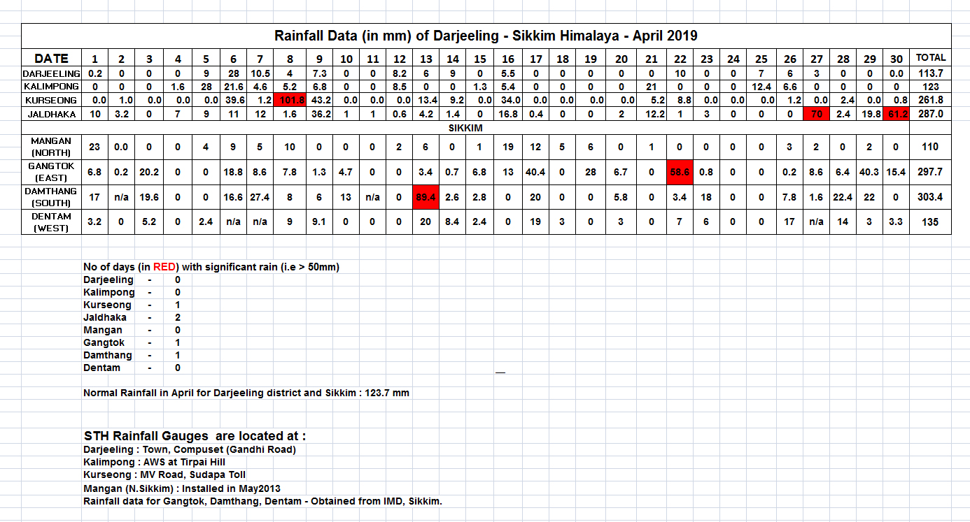
Rainfall data of April2019 for Darjeeling - Sikkim Himalaya


Rainfall information of the region is shown above.
Towards the end of April2019, the first low pressure area of the year formed in the Bay of Bengal; it eventually became Cyclone  'FANI'.
No landslides were reported in April2019 in our region.

Praful Rao,
Kalimpong district,
Darjeeling-Sikkim Himalaya