Showing posts with label floods. Show all posts

Tuesday, October 28, 2025

Extreme rainfall event in Kalimpong district: 04/05Oct2025 ('Impact on Teesta Bazar')


The first photographic records of major flooding at Teesta Bazar is of the October 1968 disaster when extensive portions of the settlement were washed away by the Teesta River. The event also led to the collapse of the Andersen Bridge — a key river crossing at Teesta Bazar — reportedly as a result of the sudden failure of a landslide-dammed lake located further upstream.
Subsequent decades saw recurring flood impacts in the area. In October 2023, Teesta Bazar was severely affected by a Glacial Lake Outburst Flood (GLOF) originating from the upper Teesta basin. This event caused extensive damage along the Teesta valley and was documented in detail by SaveTheHills (STH).
In July 2024, the locality again experienced significant flooding. Despite detailed recommendations submitted by STH regarding necessary mitigation and risk-reduction measures following the 2023 event, most corrective actions remained unimplemented. Consequently, the warning issued in the 2024 report — “Failure to take timely corrective action will mean a repetition of this whole scenario once again in 2025” — was validated when a similar flood event reoccurred in October 2025.
This pattern underscores the urgent need for comprehensive and coordinated flood mitigation interventions at Teesta Bazar, including structural and non-structural measures, to prevent further recurrence of such disasters in the future.
As expected the town again experienced major floods during the deluge of 04/05/Oct2025. STH photographer Praveen Chhetri was available at site to record the event:
Submerged Darjeeling - Kalimpong road: Two women from Teesta bazar wistfully look at the flooded Kalimpong-Darjeeling road on 05Oct2025. 
I took the photo (below) from almost the same spot on the Teesta bridge in 2024 when the river had receded and the submerged homes alongside the road were visible.
This road passes thru Teesta bazar and every time it is flooded, we have to take a lengthy 6hr detour instead of the normal 2hrs to/from Darjeeling.
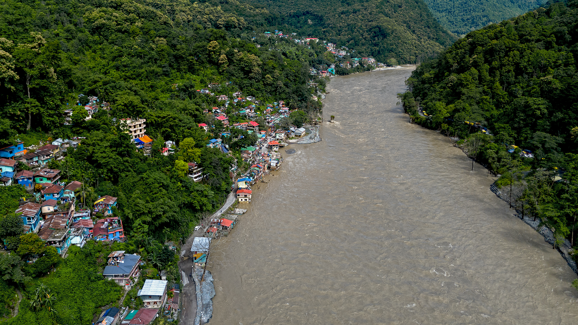
Drone image of the flooded Darjeeling-Kalimpong road at Teesta bazar on 05Oct2025
On 05Oct2025, the Teesta submerged this junction of NH10 and the road to/from Darjeeling (where motorcyclists have assembled). In the distant, the Teesta bridge linking Gangtok and Kalimpong is visible - the river is huge and stretches from one bank to the other.
Trees, stumps and debris were again dumped on the Darjeeling-Kalimpong road below the Teesta bridge by the floods of 05Oct2025.
Almost an annual event - flooded homes in Teesta bazar on 05Oct2025.
The Teesta flowing bank to bank on 05Oct2025. NH10 which connects Siliguri to Gangtok is blocked at Rabi Jhora which is a small flooded bridge on the right bank. This extreme event took place at the peak of festivities and Puja season with hundreds of vehicles choking the highways and roads. 
All photos (except one taken in 2024) by Praveen Chhetri @ Junkeri Studios, Kalimpong. My grateful thanks to Praveen (junkeristudio@gmail.com) for photographing the event as a historical record. 

Praful Rao
SaveTheHills
savethehills@gmail.com
9475033744

Monday, October 27, 2025

Extreme rainfall event in the Darjeeling district: 04/05Oct2025 (Part IIIB - damage caused by 'non- fatal landslides')

 Non - fatal landslides

The intense storm of 04–05 October 2025 triggered numerous non-fatal, rain-induced landslides of varying types and magnitudes across the Darjeeling–Kalimpong region (see above). Official estimates place the number of landslides in Darjeeling district alone at nearly 500. Given the scale of the event and the difficulty of surveying each site, this report focuses on a selection of the major landslides.

Seeyok Tea Garden - Sukhia block.

a. Area involved: Goddam dhura Ward 10 consists of 336 people in 87 homes.
b. Circumstances: Heavy rainfall began across the region on the evening of 04 October 2025. As the intensity increased, several residents—most of them tea garden workers—woke their neighbours and urged them to move to safer ground. One woman, an ASHA worker who had received RED alerts on her mobile phone, also went door-to-door warning others of the danger. Around 2 a.m. on 05 October 2025, a massive landslide struck, accompanied by a deafening roar reminiscent of an explosion. The Rangli River, normally a small stream, had swollen into a torrent, altered its course, and swept away two bridges in the area.
c. Damage: 7 homes completely damaged, 3 partially damaged. Livestock has been lost and vegetable gardens are ruined. Roads in the area are in a mess. 32 people were living in a relief camp. Many vehicles and two wheelers belonging to the community were washed away.
Goddam Dhura after the deluge of 05Oct2025. It is amazing that even after such devastation,
no one died - in large part due to the alertness of the community and timely evacuation to safer ground.
The tea industry, both in the Dooars and the hills, suffered huge losses because of the heavy rains. Here you see large landslides ruining parts of a garden - Goddam Dhura is visible in the valley below.
Drone image of Goddam Dhura on 17Oct2025. The rampage and destruction by the river is very apparent.

Taba Koshi, Mirik Subdivision (Coords 26.921391N 88.173500E)

a. Area: Taba Koshi is a series of around 40 homestays along the Rangbangh river which came up during the time of Subash Ghisingh and which started flourishing once road communication links from the area to Siliguri, Mirik and so on were established.
On 04Oct2025, due to the festive season, almost all the homestays were full with tourists from the plains.
b. Circumstances: As in other areas, rainfall started during the day on 04Oct2025 but intensified after 6pm and became really heavy later. Noticing the Rangbangh river had started crossed all danger levels, the locals started evacuating their guests to safer places after midnight. The power supply which had been erratic, thru the day because of the intense lightning on 04Oct2025 went OFF altogether at night so everything had to be done in pitch darkness and in heavy rain. So it was nothing short of a miracle that no one died.
c. Damages/loss: Many of the homestays were damaged as the Rangbangh river surged into the compounds and swept away vehicles as well as parts of the homestays in the early hours of 05Oct2025. There was significant damage to roads as well as to power lines and poles.
Damage to homes and infrastructure at Taba Koshi by the Rangbangh river - photo taken on 17Oct2025 more than two weeks after the deluge.
The Rangbangh river seen here is by all accounts a tiny stream which on the 05Oct2025 became a roaring torrent after the heavy rainfall on 04/05Oct2025. The river changed its course and threatened many homestays which were otherwise quite far from the river. Here, an earthmoving equipment is being used to correct the river's path.
The rampaging Rangbangh river caused extensive damage to roads and bridges at Taba Koshi on 04/05Oct2025.
A vehicle drives over a temporary bridge made of hewn pipes because of damage to the original bridge by the river on 05Oct2025
A smashed vehicle lying on the banks of Rangbangh river. Many such vehicles were lost because the homestay owners never believed the river, otherwise a tiny stream was capable of such devastation.
Massively eroded part of a homestay at Taba Koshi.
Damaged parts of a homestay and power lines at Taba Koshi, Mirik.
On 05Oct2025, a tiny stream (Rangbangh river) transformed into a rampaging torrent and brought down these massive boulders to a homestay at Taba Koshi.
This is the heart of tea country in Darjeeling district and the havoc wreaked by the rain and ensuing landslides is huge. Large parts of tea gardens have been severely mauled by the disaster o 04/05Oct2025.


Report by STH Survey team (which will be updated as and when possible)

From Left to Right
Steve Rai(interviews and videos with Praveen)
Yukta Acharya (Interviews and records): yuktaa1999@gmail.com
Shreya Gurung (Interviews): shreyagurung07@gmail.com
Praveen Chhetri (all drone images and photographs): junkeristudio@gmail.com

with sincere thanks and appreciation to Roshan, Rajen bhai and Priya of Darjeeling Himalaya Initiative (DHI)
and also to Aachal (Anugyalaya DDSSS) for helping with resource persons and information.

Praful Rao
savethehills@gmail.com
9475033744


Monday, October 7, 2024

Rainfall data of Sep 2024 of some towns in Sub-Himalayan W Bengal and Sikkim

Teesta river and bazar on 29Sep2024, a few days after heavy rain on 27/28Sep. The river had receded quite a bit yet it flowed nudging the bazar and the Darjeeling road at many places. The river is still swift and flows from one bank to the other.
Notice the way the heavy rain is all stacked up in the last week of the month with the first few weeks being deficient in rain.
A dramatic shift from deficient rain upto 25Sept followed by a large surplus thereafter.


The impact of the heavy rains in the month end has already been covered in a separate post here


Praful Rao
SaveTheHills
9475033744
savethehills@gmail.com

Friday, October 13, 2023

Photo essay on Glacial Lake Outburst Flood (GLOF) of 04Oct2023: the Kalimpong chapter

The GLOF of 04Oct2023 from Lhonak Glacier affected down stream areas in Kalimpong district (W Bengal) as well. As on date, three people are confirmed dead and thirteen people missing, most of these figures coming from the W. Bengal side of Rangpo.
However, many of the low lying areas along the path of the river were severely affected and residents of Teesta bazaar recounted how a swollen river had suddenly barged in, in the darkness and in pouring rain at around 3am on 04Oct2023.
Kalimpong recorded 147mm rain on 04Oct2023.


On 10Oct2023, we (Praveen of Junkeri Studios, his team and I) reached Teesta bazaar which is around 15kms from Kalimpong and spent almost 6hrs there and at Melli and Bhalukhola (See map above). We could not see other places such as Geil Khola or Tribeni because the roads are simply non existent:
* Road towards Siliguri - damaged at Rabi jhora and Likhu bhir. *Road to Darjeeling and Teesta bazaar - still under Teesta waters at the NH10, Darjeeling road bifurcation.* Road to Tribeni damaged at numerous places from Teesta bazaar to Tribeni. * NH10 towards Gangtok - precarious at many, many places, even tho it was open at that time.
Relief camp details as on 11Oct2023 are given above. Many more are staying with their friends and relatives in the vicinity.
Loss of livestock also has been a major issue with countless pigs, cattle, poultry and goats being swept away by the floods.
What struck us on reaching Teesta was the sheer size and swiftness of the river even after 6 days of the GLOF and the amount of debris/sand and sediment the river was still carrying.I wondered how this was possible? since it was not raining heavily in North Sikkim.
This is the road to Darjeeling at Teesta bazaar.
With the river still flowing from one bank to the other and at much higher level (because of the silt deposit), parts of the road to Darjeeling are still submerged.
A dog lazily scratches himself, while sitting on the roof of a home which is still under water at Teesta bazaar. We were told that 45 homes had been damaged or destroyed in this area. Notice the water level is almost at the same level as the road. We observed this everywhere - the water level has gone up dramatically, even as much as 20-30 feet and now the river is flowing much closer to populated areas and the railway tunnels.
Sunayana Devi stands on the roof of what was earlier her kitchen. Half of her three storey structure is now filled with sand and the sudden invasion by the flood waters prevented them from saving anything. Like many so many others we spoke to, she wants the government to relocate her to a safer place.
An elderly lady and two young relatives check the damage to their home in Teesta bazaar. The river is today just a few meters away from their home which itself is dangerously cracked. - photo by Praveen.
The ferocity of the flood waters is unimaginable - the Teesta dumped 10-15 feet of sand on these two vehicles (and everything else) in its 3 hour rampage at the center of the bazaar. We were lucky this time - our casualty figures are far less than what was expected.
Volunteers clearing up in Teesta bazaar take a break from their work - photo by Praveen.
Remains of a brand new resort in Teesta Bazaar after the GLOF. Huge chunks of whatever is seen in this image are cracked and dangerously tilting towards the river - photo by Praveen.
Even though not many lives were lost, the GLOF wreaked havoc on the infrastructure in the 3-4 hour event. All this comes at a time when people of this region are looking forward to celebrating the festive season ahead - photo by Praveen.
A priest and a devotee perform a puja on the banks of the Teesta perhaps to pacify the river Gods. The river looks deceptively calm.
Fresh rations stock at Melli bazaar (W Bengal side).
The worst affected here were the two shanty colonies (located below the Melli bridge) which comprised of almost 30 odd homes. Nothing remains except a solitary, sand covered Masjid where the the predominantly Muslim dwellers used to worship.
As with others, a victim wanted the government to swiftly shift them to a safer location.
At most places we visited, there was no shortage of food or clothing for the time being - but winter is nigh and these people will need sustained care to help them recoup.
Drone image by Praveen of Melli stadium (Sikkim) covered with sludge. Do notice at where the Teesta is flowing.
Teesta stomps into the courtyard of the Tribeni Covid Hospital.
This large structure was used as the GTA Covid Hospital during the pandemic and is extensively used by tour operators to entertain tourists even overnight. Luckily no one was around when Teesta came calling on 04Oct2023 at 3am.
One can see quite a lot of damage in the right flank of the building in the drone image by Praveen (below).
NH10, opposite Melli town.
The GLOF of Oct2023 together with the dam operations is going to make NH10 maintenance a headache. Numerous places along the NH10 are subsiding and this makes driving at night on the highway even dangerous.
Another image by Praveen of the damage to NH10 is below
The UCNI church at Bhalukhola, near Melli. This is low lying area which was flooded during the GLOF.
The living room of a home at Bhalukhola - an entire lifetime's earnings have been reduced to sludge and mud covered trash- Photo by Praveen
There was a shanty colony here in Bhalukhola, which has been swept away by the flood. The more permanent structures have survived but will need extensive repair.
But looking at the proximity of the river and the elevated level at which it is flowing, will anyone risk returning to these homes? Photo by Praveen.

An after thought and a sense of deja vu
I find it strange that on 10Oct2023, I did exactly the same thing I did from the same spot, 55years ago in Oct1968 - that is, photograph the devastation caused by a raging river from the opposite bank of the Teesta.
I have written about it here
 
Update on 16Oct2023: Teesta-Darjeeling road open 'but repairs still going on', as reported by Mr Soam Namchu of Glen Family Foundation today in STH Whats App group 'Hazard Alerts'
Photo credit: Soam Namchu


Again, my gratitude to all those who helped make this documentation possible.


Praful Rao
Kalimpong district
Darjeeling - Sikkim Himalaya
savethehills@gmail.com
9475033744