Showing posts with label STH stormwatch. Show all posts

Friday, March 18, 2022

STH activities: Raising awareness on Disaster Risk among common people and our Stormwatch (Early Warning) Activities


 Responding to the above invite, I talked on disaster risk, changing rainfall patterns and how to convert a smart phone into an effective early warning device. The meeting was attended by 30 odd officials, staff and workers from the Sericulture Research Station and from an agricultural institute.
STH stormwatch activities
Though this activity is not featured in this blog as actively as earlier, STH has been more than active in social media mainly in our What's App group called HAZARD ALERTS (1 &2).
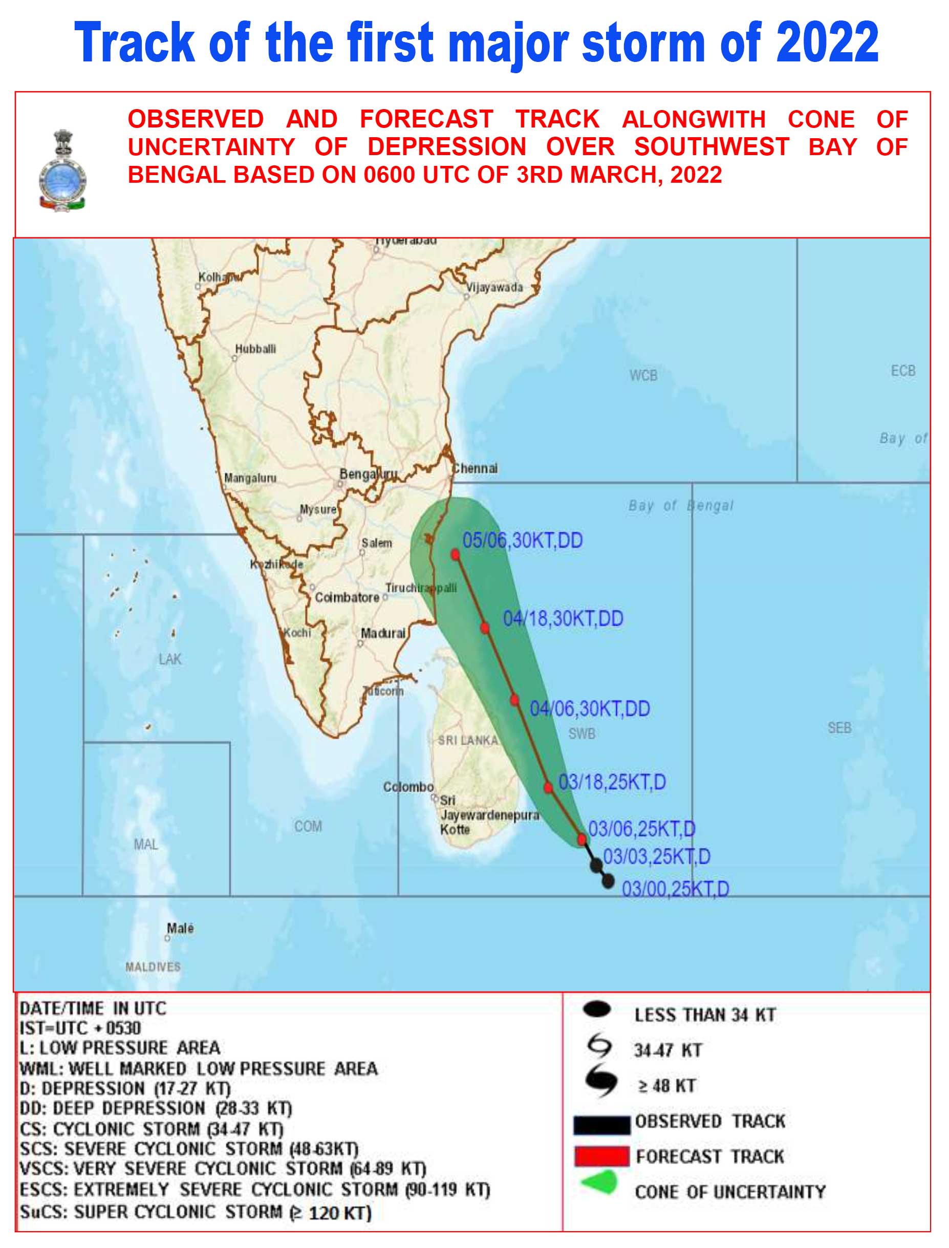
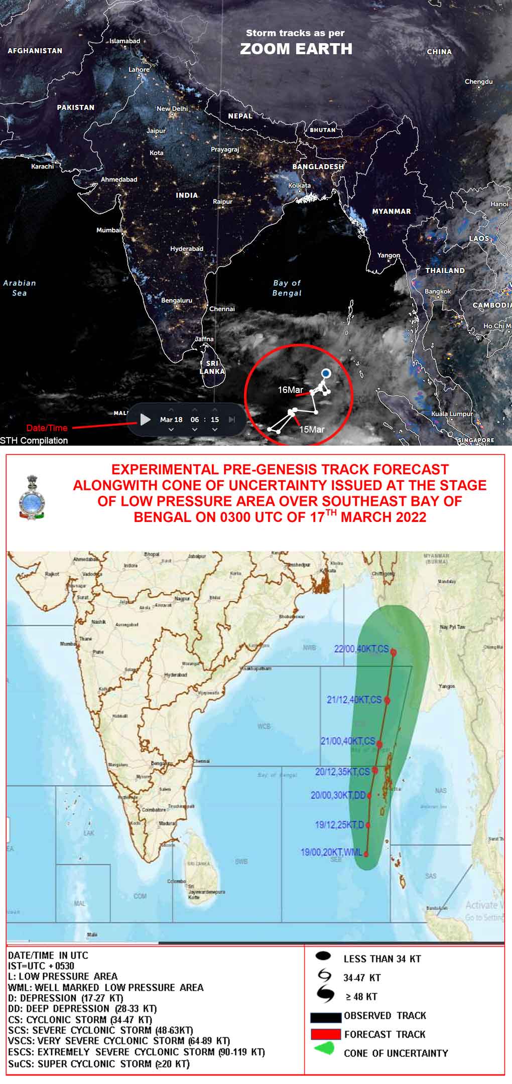
Placed below are some images of an earlier storm we tracked in the first week of March and another one which is still intensifying in the Bay and will eventually become a cyclone in another 3 days time.
 
Praful Rao
Kalimpong District
Darjeeling- Sikkim Himalayas

Monday, December 5, 2016

Thursday, October 27, 2016

STH stormwatch : Death of Cyclone 'Kyant'

Extract of JTWC statement on Cyclone 'KYANT' :-
' UPPER-LEVEL ANALYSIS SHOWS A POINT SOURCE JUST TO THE EAST OF THE SYSTEM INTRODUCING SOME EASTERLY WIND SHEAR NOT CONDUCIVE FOR REDEVELOPMENT. THE UPPER LEVEL ENVIRONMENT IS EXPECTED TO REMAIN UNFAVORABLE AS THE DEEP-LAYERED RIDE BUILDS ESTABLISHING PREDOMINANT EASTERLY FLOW ALOFT. THE REMNANTS OF TS KYANT IS EXPECTED TO CONTINUE ON A TRACK TO THE WEST-SOUTHWEST ALONG THE SOUTHERN PERIPHERY OF THE BUILDING DEEP-LAYERED RIDGE TO THE NORTHWEST. THIS IS THE FINAL WARNING ON THIS SYSTEM BY THE JOINT TYPHOON WRNCEN PEARL HARBOR HI. THE SYSTEM WILL BE CLOSELY MONITORED FOR SIGNS OF REGENERATION.'

Praful Rao,

Kalimpong,
Dist Darjeeling


Friday, October 21, 2016

STH Stormwatch : Depression in the Bay of Bengal (21Oct2016)

Updates will be posted as necessary

Update 1 (JTWC IR image of two storms in our region)
Predicted storm track (shown in RED) is an approximation (NOT accurate!).

Update 2 (23Oct2016)

Update 3 (23Oct2016) - IMD predicted track
 
Praful Rao,
Kalimpong,
Dist Darjeeling

Monday, June 8, 2015

STH Stormwatch : Reporting Cyclone 'Ashobaa', the first cyclone of 2015 in Northern Indian Ocean

Tracks in Arabian Sea are from here
Till date no low pressure/depression or cyclone has formed in the Bay of Bengal.

Praful Rao,
Kalimpong,
Dist Darjeeling

Friday, October 10, 2014

STH Stormwatch: Cyclone Hudhud upgraded from 'Severe' to 'Very Severe'

Updates (upto 10Oct2014) on track and information of Cyclone 'Hudhud' are here

Praful Rao,
Kalimpong,
Dist Darjeeling

Tuesday, September 16, 2014

STH Stormwatch (16Sep2014) : Reporting a Low Pressure in Bay of Bengal

IMetD excerpt
'A   low   pressure   area   has   formed   over   northwest   and   adjoining   westcentral   Bay   of   Bengal   and  coastal   areas   of   Odisha. Associated upper air cyclonic circulation extends upto 7.6 km above mean sea level
tilting southwestwards with height'

Updates will be posted as necessary

Praful Rao,
Kalimpong,
Dist Darjeeling

Sunday, July 20, 2014

STH stormwatch (20Jul2014) : Reporting 4rth low pressure area in the Bay this season and also rainfall update


‘A low pressure area has formed over north Bay of Bengal and adjoining area of
Gangetic West Bengal and Odisha. Associated upper air cyclonic circulation extends upto 7.6 km above mean sea level. It may become well marked during next 24 hr’
Updates will be posted as necessary (see info on previous low pressure areas here 1, 2, 3)

Placed above in chart form is the weekly % Departures of Rainfall for the Monsoon 2014 for Sikkim and Darjeeling district.

Praful Rao,
Kalimpong,
Dist Darjeeling

Wednesday, December 11, 2013

STH stormwatch (11Dec2013) : Cyclone 'MADI' downgraded further into a depression

Cyclone 'MADI' has now been downgraded to a deep depression and is likely to lose strength further to become a depression in the next 6 hrs.


Praful Rao,
Kalimpong,
Dist Darjeeling

Saturday, November 9, 2013

STH stormwatch (09Nov2013) : Low pressure over Andaman Sea

2013 seems to be ending with a bang, what with a low pressure brewing up in the Andaman sea in early Oct and mutating  into  Very Severe Cyclone Phailin within a week and  with Super Typhoon Haiyan literally obliterating parts of Philippines yesterday.
IMetD is now reporting another low pressure in the Andaman sea which it cautions will intensify into a well-marked low pressure area within 24 hrs - that is exactly what happened with Phailin.

Praful Rao,
Kalimpong,
Dist Darjeeling.

Sunday, October 13, 2013

STH stormwatch (update) : Cyclone Phailin, after the landfall (13Oct2013.1)


'Very Severe Cyclone' Phailin made landfall almost exactly as predicted around 2100h on 12Oct2013, near Gopalpur. It has moved inland and should be now downgraded to a 'Cyclone'.
As per reports coming in, the damage and certainly the fatalities seems to be much less than expected perhaps because
a. Enough lead time was available to prepare and mobilize forces.

b. Large scale evacuation carried out.
c. Overall preparedness, in terms of storm shelters etc was better.
d. Most importantly and mercifully, the storm itself was of lesser intensity than forecast.
(see Automatic Weather Station Report  of Bhubaneswar agro for rainfall and wind speed records)
While hoping the worst is over, the storm is still potent and very much around and will have to be watched closely and also disaster management in the affected areas will now have to move onto the next phase viz assessment of needs and damage, relief , rehab and reconstruction.
Updates will continue on STH stormwatch.

Praful Rao,
Kalimpong,
Dist Darjeeling


Saturday, October 12, 2013

Tuesday, October 8, 2013

STH Storm watch: Depression over North Andaman sea


"The low pressure area over north Andaman sea and neighbourhood intensified into a depression over north Andaman sea lay centred at 0830 Hours IST near Lat. 12.0°N & Long. 96.0°E. It would intensify into deep depression and further cyclonic storm by tomorrow. It would move in west­-northwestwards towards north Andhra Pradesh and Odisha coast during next 72 hours." 
(Source : IMetD)

Futher updates will follow.

Rohan Rao,
Kalimpong,
Dist-Darjeeling,
Email: rohan.rao1313@gmail.com

Wednesday, August 28, 2013

Satellite Imagery : How reliable is it for rainfall / adverse weather prediction?

Satellite Imagery (both Vis and IR) is an invaluable tool for the lay person to obtain information on the formation,development and movement of weather systems. It has been a part of the STH blog for the past 3 yrs and is an integral part of the "STH Stormwatch" series in which we monitor weather systems that form in the Bay of Bengal.
This information, earlier only available to scientists and meteorologists is now available to anyone with internet connectivity. Having said this however, it  is not advisable to depend on satellite images exclusively as a method to predict rainfall / adverse weather, the next few images will explain
why :


Thus it is clear that satellite images though vital for early warning CANNOT give foolproof warnings. For those interested the link to the Darjeeling "Hurricane" is here.

Rohan Rao,
Kalimpong,
Dist - Darjeeling,
E-mail - rohan.rao1313@gmail.com

Saturday, July 20, 2013

STH Stormwatch ( 20 July 2013) : Reporting a Low Pressure Area (LOPAR) in Bay of Bengal

As a part of  "STH stormwatch", we maintain a watch on the weather activity in the Bay of Bengal with a view to provide advance information and timely warning. The report below is a part  of this endeavour:-

"The  low pressure area  over northwest Bay of Bengal and neighbourhood persists. 
Associated upper air cyclonic circulation extends upto mid­tropospheric level tilting 
southwestwards with height also persists."
Source : IMD

We will post updates on the LOPAR if necessary.

Rohan Rao
Kalimpong,
Dist - Darjeeling,
E-mail : rohan.rao1313@gmail.com

Thursday, July 11, 2013

STH Stormwatch (11 July2013) : Reporting a low pressure build up in the Bay of Bengal

 "The low pressure  area over Odisha &adjoining northwest Bay of Bengal and its 
associated cyclonic circulation extending upto mid­tropospheric level tilting southwards 
with height persists. "
(Source : IMD Website)


 A low pressure area has formed in the Bay of Bengal and is now over Odisha and the adjoining North West Bay of Bengal, we will be tracking its movements over the next few days and updates will be posted on this blog.

Rohan Rao,
Kalimpong,
Dist - Darjeeling,
Email - rohan.rao1313@gmail.com

Sunday, June 23, 2013

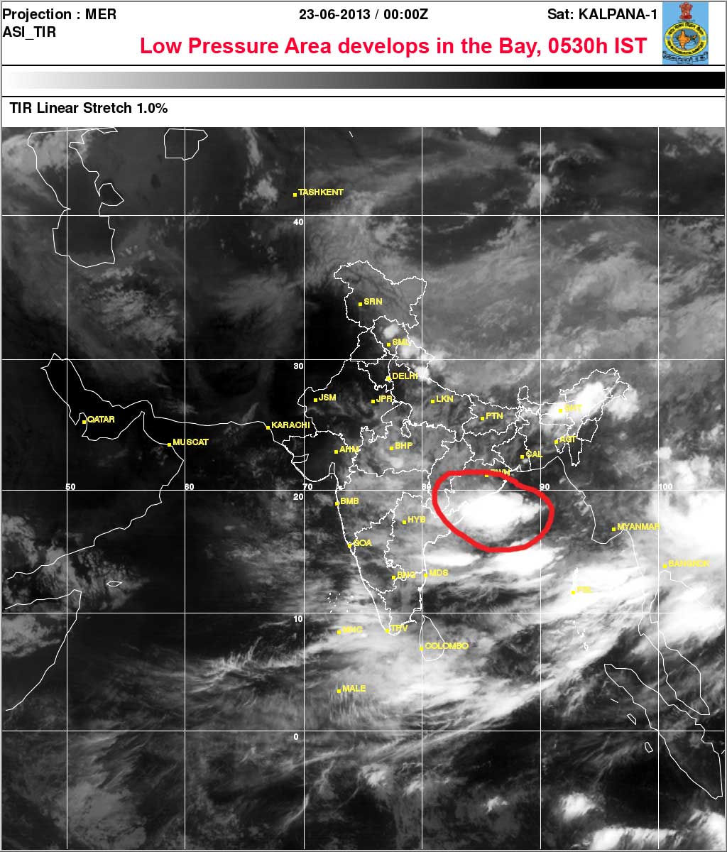
STH storm watch : Reporting a low pressure area in the Bay of Bengal (23Jun2013 - 0530h IST)

As a part of STH storm watch we monitor the activity in the Bay of Bengal continuously during the monsoons  so as to forewarn readers and communities about the formation, movement and intensity of weather systems which may affect us.
Today IMD states :

"The low pressure area now lies over Odisha and adjoining areas of northwest Bay of Bengal associated cyclonic circulation extending upto 7.6 km a.s.l. tilting southwestwards with height."

Praful Rao,
Kalimpong