Showing posts with label flooding. Show all posts

Monday, September 30, 2024

Extraordinary rains of September end 2024 (in the Darjeeling - Sikkim Himalaya).


Until the 23rd, the month of September 2024 for us in the Darjeeling-Sikkim Himalaya turned out to be very dry and inordinately hot, prompting a member of the SaveTheHill's What'sApp group 'Hazard Alerts' to write:

'What does it mean, no rain in Kalimpong, Sikkim or Darjeeling?? Paddy fields are drying, springs and streams have dried already, this year "MUL PHUTENA", meaning ground aquifers were not recharged completely. This situation warns of the chaotic food insurgency especially to those who wait for food from farmers. Poor farmers look at the sky, it looks blue, no cloud, and he screams for his hardships and crop failure. I'm a farmer, what option do I have now??'

Another member post this cartoon about the prevailing hot weather:

Then on 24Sep2024, another LOW pressure area, in a series of bumper to bumper lows which had formed in the Bay after 17July2024, developed as shown below:
IMD issued a number of press releases about the weather systems causing the heavy rain and likely weather which would ensue:

Based on IMD and other inputs, STH posted satellite imagery and weather updates continuously during the period in our WhatsApp groups 'Hazard Alerts, Hazard Alerts 2, Hazard Alerts 3' - we also used other social media handles to publicize the heavy rainfall warnings.

Rainfall data

On 29Sep2024, IMD gave us a GREEN (ie no warning after 3 days of RED warning and 1 day of orange warning in the above period) and we had a dry day after 5 days of non-stop rain.

The average monthly rainfall for September in Sub-Himalayan W Bengal and Sikkim is 388.1mm - the 5 day rainfall of Sept2024 end, as seen above came close to or in the case of many towns, exceeded the monthly average and thus we swung from a total deficiency of rain in the first three weeks of September to a gross excess of rain, all of the large volume of water coming at the end of the monsoons when the mountains are almost saturated with water. As such the impact of this unusual heavy rains was huge in the region.

IMPACT

Firstly and most importantly, there were no fatalities even though we did have many landslides and near misses.
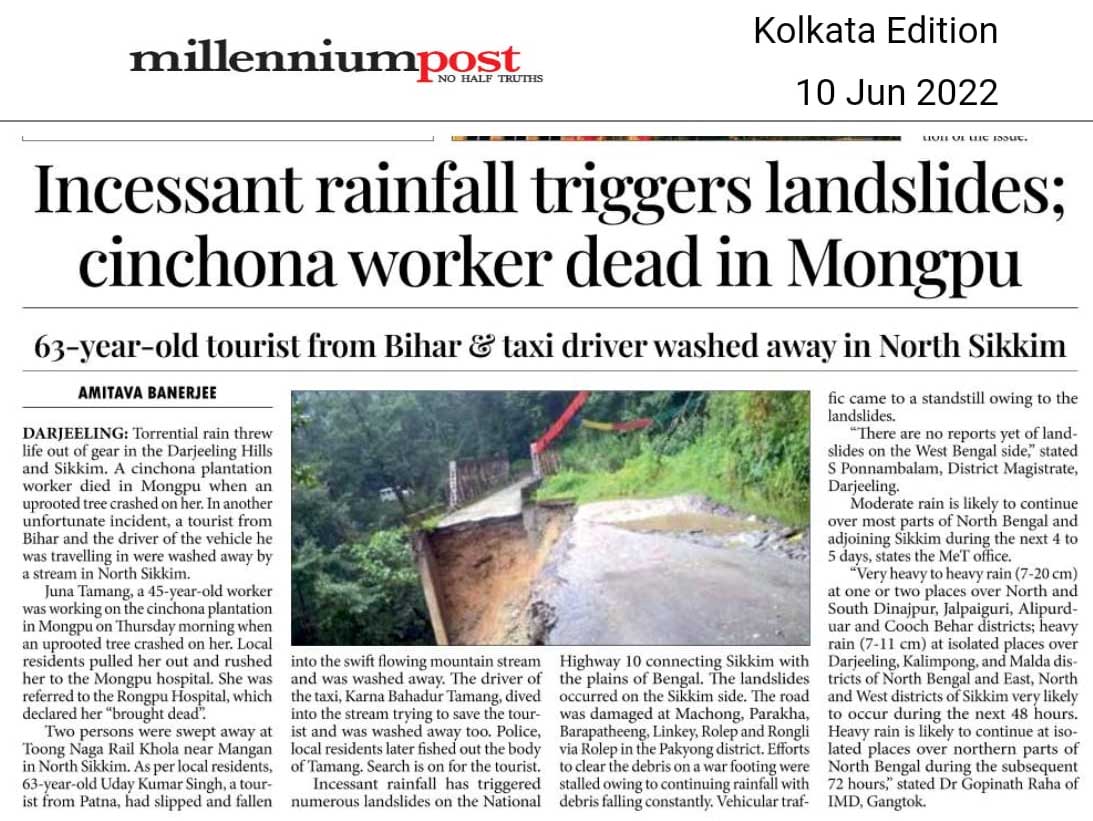
Road Communications: NH10
The already poor state of road communications especially in the Teesta valley suffered further set backs.
Landslide on NH10 near Teesta bridge on 27Sep2024 (27 03 40.2 N 88 25 35.3 E)
Large landslide on NH10 near Melli (27.08388889N 88.45098611E)
Other places in the Teesta Valley
Flooded Darjeeling - Kalimpong road near Teesta bridge, 28Sep2024. The debris and sand deposits by the GLOF of Oct2023 had raised the level of the Teesta river by as much as 4-5m so heavy rain
always results in the river flooding this road.
Teesta Low Dam Project III at 27Mile and the flooded Bangay bazar bridge
(26°59´38.20´´N 88°26´32.83´´E)
Flood affected areas of Teesta bazar. As mentioned earlier, the GLOF of Oct2023 has pushed the riverbed levels up by 4-5m and as such the river runs perilously close to many densely populated areas - Melli, SIngtam and Rangpo to name a few. Heavy rain in the valley invariably results in flooding of these areas.
Melli town and stadium ( 27°05´23.03´´N 88°27´28.01´´). The stadium which was entirely covered by debris and sand by the GLOF in Oct2023 had been painstakingly cleaned by the town but it has been rendered unusable by the repeated flooding of the river.
The GTA Covid Hospital (27°04´48.63´´N 88°25´50.37´´E) lying derelict on the banks of the Rangeet river since the GLOF of Oct2023. Parts of the one lane road leading up to the hospital from Teesta Bazar has been under the river for a year now and the recent rains have inundated even more areas of the road.

Other parts of the Kalimpong and Darjeeling districts
Major landslide in the vicinity of Kalimpong town at the by-pass road, 7th mile (27 04 13.9 N 88 26 56.8 E). In Sep 2024, Kalimpong received less rain than Darjeeling and Kurseong and as such we never had as many landslides.This large landslide took place on 28Sep at around3.30pm.
Subsidence due to mountain stream erosion (jhora) in a densely populated area of Kalimpong municipality (27 03 47.0 N 88 27 45.8 E). The subsidence (seen here covered by plastic sheets to prevent water ingress) occurred during daytime on 28Sep2024 when the stream was gorged with runoff from upstream paved surfaces. My concern here is that this whole area is located above a landslide prone zone on which we have done a story in 2010.
Landslide in the Darjeeling Municipal area at Hooker Road, on 26Sep2024
Landslide at Lower Bhaktey bustee in Darjeeling

Sikkim received much less rainfall in late Sep2024 resulting in much less devastation and landslides.

I am sure there were many more unreported landslides and instances of flooding caused by the unusual heavy rains and we will keep updating this blog on the reports, when received. We will also be surveying the affected areas in due course of time.

My thanks to all HA members whose images and reports I have used liberally here and elsewhere - all with the intention of recording the event for posterity.

Documentation of parts of the above report was supported by Royal Enfield, as part of their Social Mission Initiative


Praful Rao
SaveTheHills
savethehills@gmail.com
9475033744


Thursday, October 19, 2023

Photographic record (18Oct2023) of Geil khola section of NH10 - post Lhonak Glacier GLOF.

One of the main casualties of the devastating Lhonak glacier GLOF on 04Oct2023 was the road communications and that too mainly the impact of the floods on NH10 which is the lifeline for the landlocked, mountain state of Sikkim and of Kalimpong district in W Bengal. Of the approx 114km distance from Siliguri to Gangtok, 65kms of NH10 winds itself along the banks of the Teesta.
More than two weeks after the GLOF of 04Oct2023 which shredded the highway at many places the road communications from Gangtok to Siliguri along NH10 has not been restored till date - neither the state highway which connects Darjeeling to Teesta Bazaar.

On 18Oct2023, I photographed the above section of NH10 from the sheer cliffs of Kalimpong district which overlook the highway from the opposite hill - with the intention of preserving the images of what was an extraordinary event for us living in this region.
The above image of Oct 2021 shows a very active landslide (A) at 29th Mile on NH10 (27 01.013N 088 26.087E) and Bangay bazar (B) on the banks of the Teesta.
Telephoto Image of NHPC's TLDPIII and parts of Bangay bazar on 18Oct2023, submerged by the GLOF. Dam operations on TLDPIII has been stopped by the local political party (GTA) for the time being. Do notice the width of the Teesta river and the color of its water which indicates it is still loaded with silt.
                                       A very active 29the Mile landslide zone in 2021.
This year the 29th Mile landslide remained stable even during the GLOF period.
Close up view of the same area on 18Oct2023. The huge mounds of sand on the right bank indicate river levels during the GLOF. NH10 also appears to have been eroded at places.
Likhu Bhir (27 02.181N 088 25.661E) was the most serious landslide on this route decades ago (see image below). After being relatively stable for years, it was reactivated by the GLOF. One can see trucks carrying construction material plying over the slide.
Geil khola (27.028965N 088.427644E) was one of the places which was hit by the GLOF of 04Oct2023. Notice the partly buried homes on the river bank. The District Administration has set up a relief camp at Geil Khola.
Geil khola and its surroundings on 18Oct2023.
Geil Khola - Likhu bhir section of NH10 on 18Oct2023.
It seems ironic that the Kalimpong element of Darjeeling Himalaya Railways (DHR) which used to operate the narrow gauge train from Siliguri to Geil Khola, discontinued its Kalimpong operations after the 1950 disaster in our region.
Damage to DHR tracks in Darjeeling by the June 1950 disaster (photo kind courtesy Das Studio, Darjeeling)
File photo of the Geil Khola - Teesta Bazaar section of NH10 in May 2017.
The same section of the road after the GLOF - notice the level and size of the Teesta river and the many places eroded on NH10.
This place is in the vicinity of the Teesta bridge. The erosion of the road along the banks of the Teesta can be seen here.
Will the NHPC TLDP III dam operations under circumstances where the level of the river has now risen significantly affect NH10?
Also the safety of the thousands of vehicles which will ply on the highway when it is reopens and especially during the monsoons of 2024 are questions which need to be pondered upon.

Praful Rao
Kalimpong district
Darjeeling Sikkim Himalaya
savethehills@gmail.com
9475033744

Sunday, October 15, 2023

Reconstructing a rough timeline of the South Lhonak Lake GLOF (04Oct2023)

I have talked to many, many people and have received an equal number of versions about when the GLOF started. Some say the lake outburst started as early as 9am on 03Oct2023 and became a full blown flood later;still others say it started between 12.00 midnight and 1 am on 04Oct2023.
What is true is in the early morning of 04Oct2023, in the midst of heavy rain and darkness, thousands scrambled to safer ground leaving everything they possessed behind, others were not so lucky and got swept away by the swirling, muddy waters of a river gone berserk. In an attempt to preserve the actual happening and time lines I am publishing screen shots of the telephone calls made and also the WhatsApp messages exchanged between two of my friends and me. One of them is in Kalimpong and the other in Mangan. I have not taken their permission to print this material as such I have removed all identities.

Hesitantly between 2.30 & 3.30am or so, I made many calls to friends both in Sikkim and elsewhere to verify the reports which were coming in. Most of the phones were either switched OFF or did not respond.
As per WhatsApp message received from the Kalimpong District Administration on STH Whats App group 'Hazard Alerts' at 2.49am, they had issued an alert in the low lying areas, another message at 2.50am from the East Sikkim District Administration reads 'low lying areas being evacuated'. These actions and alerts within the local communities made thousands move to higher ground at that unearthly hour - which is why they are alive today.
Screen shots of actual conversations and videos which were sent on Whats App in the early morning of 04Oc2023 are placed below (do understand that I was talking on the phone with my friends while the messages were also being sent) :
I have uploaded the first video sent to me at 2.52.36am on 04Oct2023 where a person says the 'the dam has burst, confirmed it has burst - let us run away'.


Praful Rao
Kalimpong district
Darjeeling-Sikkim Himalaya
savethehills@gmail.com
9475033744

Friday, June 24, 2022

The deluge of Jun2022 (affecting Sikkim, Assam, Meghalaya (India), Bangladesh (Sylhet, Sumamganj) and Bhutan.

The north east of India and Bangladesh are no stranger to flooding - which is an annual event. This year the flooding started in May2022 but peaked in mid June2022 with rainfall records of more than a century being broken.

Meteorological conditions from 1Jun22 to 20Jun22

Meteorological conditions which led to the extraordinary rainfall in east India and Bangladesh were as follows:
a) An east west trough of low pressure existed for almost 3 weeks from western India thru Bihar, Sub-Himalayan West Bengal to Assam.
b) Westerly winds prevailed in much of mainland India as a result, both west and central India are, at the time of writing deficient in rain.
c) There was a persisting lack of weather activity in the Bay of Bengal with no lows or depressions forming for over a month.
d) Strong southerly wind flows to northeast India from the Bay pumped in extraordinary amounts of moisture into the region (see below).


Satellite Images of Clouding


Affected areas (India)


Indian states Assam, Meghalaya, Sikkim, and Tripura were severely affected by the excessive rainfall. The deluge started in May itself, when Assam got 62% above normal pre-monsoon rains (Zaman, 2022).
Some residents of Hojai district (Assam) alluded to faulty dam operations also being one of the causes of the deluge, “Even if there was a flood earlier, it used to take two to three days for the whole village to be submerged. This time, the entire village was submerged within 10-12 hours.” (Zaman, 2022)

Affected areas (Bangladesh)
Bordering the country of Assam, Bangladesh also faced the same wrath. It has been observed that in 122 years such flooding in the Sylhet region in Northern Bangladesh has not been observed. One of the fundamental reasons for the worsened condition of Bangladesh was the cascading water coming from the hills of Meghalaya. Assam and Meghalaya have received an excess of 125% rainfall as on 16Jun22.
'Heavy monsoon rains and water from upstream in India's northeast have inundated large parts of the Sylhet division, leaving millions of people marooned and triggering a humanitarian crisis. The flash floods swept away homes and inundated farmlands, forcing families to seek shelter on higher ground and temporary flood shelters, while power cut is making life miserable. Experts considered the flood worse than the ones they had experienced in 1998 and 2004. The crisis struck at a time when the people of the division were recovering from unexpected recent floods that hit in late May. An estimated 7.2 million people are affected
by this sudden flash flood and water congestion in nine northeastern districts of Sylhet, Sunamganj, Moulivazar, Habiganj, Kishorganj, and Netrakona, Brahman Baria, Mymensing and Sherpur. Among the nine districts, five heavily impacted are Sylhet, Sunamganj, Moulivazar, Habiganj and Netrakona. As many as 472,856 people have been taken to around 1,605 shelter centres in a combined effort of the Army, Navy,
Fire Service, and the local authorities, according to the Ministry of Disaster Management and Relief (MoDMR). Many households are isolated due to floods, while some have taken shelter in open areas. The safety and security of women and girls in those households are at high risk'- (Source: UN, Bangladesh)

Affected areas (Bhutan)
Information not available

Rainfall Activity from 15Jun2022 - 18Jun2022

Comparison between the monthly mean average for June with the observed rainfall activity has been shown below. The monthly mean average is calculated by using daily rainfall data from 1989 to 2018 and analyzed by IMD, Pune.

  •  In  4 days, regions in Assam and Meghalaya received their entire month's rainfall.
  • Sikkim observed the same in 6 days.

Observed Rainfall statistics:


Impact of the Deluge (India)
The extreme rainfall resulted in floods and landslides  which severely impacted large swathes of the North East Region. Critical communication networks in terms of the Indian railways and National Highways (NH) were disrupted and Tripura faces acute shortage of essential commodities as parts of NH 6 (connecting Tripura, Mizoram, Manipur to the rest of the country) under Meghalaya's Lumshnong area have been affected by landslides.

Assam has reported landslides in Dima- Hasao, Goalpara, Morigaon, Kamrup and Kamrup(M) in the last few days. (Humanitarian Aid organization, 2022).

Meghalaya also reported landslides from three districts – East Khasi Hill (Mawsynram) ,South West Khasi Hills ,South Garo Hills and Llumshnong in Jaintia hills.

Some of the roads impacted in Sikkim due to many large and small-scale landslides are:

● 20th mile, NH10 between Singtam and Rangpo
● 17th mile Gangtok
● Singtam-Temi Tarku stretch
● Rangpo Rorathang stretch
● Jorethang-Namchi road

Latest report by the New York Times reports at least 116 fatalities due to flooding, lightning strikes and landslides in India and Bangladesh (NY Times, 2022). The Humanitarian Aid International reported that as of 22Jun22 there were 28 districts, 2,930 villages with over 19 lakh people affected and 54 fatalities in Assam.

Given below are statistics from the Assam State Disaster Management Authority from their Daily Flood Reports, from 16Jun22 - 19Jun22.

Whereas we found much information and well updated data in the Assam State Disaster Management website, there was virtually no information on the recent floods and landslides in the Meghalaya State Disaster Management website

Impact of the Deluge (Bangladesh)
The UN report is placed here

Impact of the Deluge (Bhutan)
Information not available

Images/Media reports


Ankit Mankar (Azim Premji University, Bangalore)
Shreya Gurung (SaveTheHills)
Praful Rao (SaveTheHills)