Showing posts with label earthquake. Show all posts

Monday, September 12, 2022

Tanyang, a village on the edge (11Sep2022)

Tanyang, a tiny village (in Samalbung GP, Kalimpong 1) composed almost entirely of people from the Lepcha community is approximately 2hrs drive from Kalimpong. It is a village of farmers and as such, land being their most precious asset, the loss of 10-12 acres of land due to the landslides creates a huge dent on the earnings and livelihoods of the people.
I was rather surprised to hear of a recent landslide in the village because of the mild summer monsoons this year and a deficiency in rains in July and August 2022.
We were in the landslide affect areas adjoining the main village yesterday where we did a drone survey of the landslide.
A Google - Earth image of the landslide dated 1/1/2021 is placed below:

The local people, who are often the best judges, offered various reasons for the cause of the landslide:
  • It was initially triggered during the major landslide disaster of Oct 1968, which is totally believable since many of the old landslides started with this event.
  • Some of the villagers said it was the Sep2011 Sikkim earthquake which had created the cracks and the fissures.
  • Everyone seemed quite sure that the heavy rainfall on 26Aug2022 had caused the recent landslides which necessitated the evacuation of 10 families from the immediate vicinity of the landslide.
  • Some said water was oozing out from inside the slide which probably caused the slide.
  • One could safely rule out human activity as a probable cause. There is no urban built up areas here, population is low, no major road construction or other developmental activity. No jhora nearby which could have caused the erosion and the river at the base of the mountain is quite far and could not have caused toe erosion.
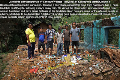
     
     
    10 families, including women and children had been evacuated and were housed in temporary structures and also in the ICDS building

When interviewed the women folk especially were apprehensive of the future and wanted to be relocated close by somewhere and quickly since the future of the family and children were at stake. 

 Media report of the landslide is placed below:
The link to the drone footage and interviews will be put up as soon as it is ready.

Praful Rao
Kalimpong district
Darjeeling Sikkim Himalaya

Thursday, April 20, 2017

Training program on "Earthquake and Landslide Management' at Darjeeling (20-22Apr2017)

The program is being organized by the Govt of W Bengal and SaveTheHills is facilitating the attendance of 6 participants from Kalimpong to attend the 3 day course. In addition, 4 civil engineering students from SMIT, Majitar (Sikkim) will be attending the event on 21Apr2017

Praful Rao,
Kalimpong dist.
Darjeeling-Sikkim Himalaya


Monday, March 27, 2017

Earthquake report: 27Mar2017, NE of Kalimpong

Date of Occurence:
27/03/2017
Time:
03:12:09 HRS(IST)
Intensity:
SLIGHT
Magnitude:
4.6
Depth:
10 KM
Epicentre:
Lat. 27.3°N Long.88.6°E
Region:
EAST SIKKIM


 As per the above report the intensity is 'Slight' but mark my words, we were jolted out of bed in Kalimpong by a strong but momentary shake  at approx 3.15am which knocked off the power supply for about 20 mins. The epicenter was 26.1km NE of Kalimpong, near Pakyong.
5hrs later at 8.10am, we have not received any report of casualties or damage.

Praful Rao,
Kalimpong district,
Darjeeling-Sikkim Himalaya


Wednesday, May 20, 2015

Four maps which speak a thousand words...

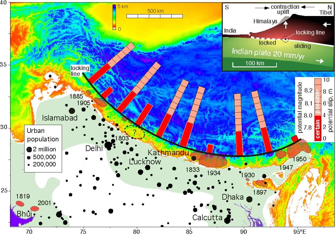
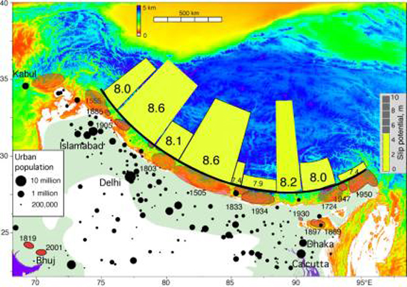
The USGS is undeniably one of the most authoritative bodies in the world, when it comes to seismic studies. In its tectonic summary of the Himalaya and its vicinity, it states "The northward under thrusting of India beneath Eurasia generates numerous earthquakes and consequently makes this area one of the most seismically hazardous regions on Earth."
Unfortunately, the subduction zone running from Kashmir to Arunachal Pradesh (see map above or pdf file here) passes almost directly below where we live (Darjeeling-Sikkim position in above map is approximate and not from USGS).
In India, the IMD is responsible for seismicity of the region and the seismic map of India with a focus on the Darjeeling-Sikkim region is placed above.
The GSI is the nodal body in the country looking after landslide hazards and as per them, the Darjeeling-Sikkim Himalaya is amongst the most hazardous areas (see above) in the country with regard to landslides.
Dr David Petley is a world authority on landslides and we consider an honour that STH has been featured a number of times on his famous landslide blog
Placed above is his map on fatal landslides in Asia and without a doubt, he states the most fatalities  in the world due to landslides takes place along the ' southern edge of the Himalayan arc' - which is, sadly where we live.

What never ceases to amaze me is how in the face of such stark, cold scientific evidence and the huge spurt in disaster along the Himalayas, we still continue to bury our heads in the sand and think disasters can happen to everyone - except us.

Praful Rao,
Kalimpong,
Dist Darjeeling

Wednesday, May 13, 2015

The 12May2015 Nepal Quake : An expert's view


Dr Malay Mukul of IIT Mumbai (Dept of Earth Sciences) hails from Kalimpong and has contributed numerous articles to this blog. After yesterday's quakes which rattled much of India, I posed him this question :
'What the hell is happening in our region?'
His reply is placed below :-
_________________________________________
The 12May2015, 7.3 earthquake in eastern Nepal was not completely unexpected. When we had the December 2004, 9.1 Indian Ocean Earthquake, there was similar 8.6 shock in March 2005. There were also two 8+ events in 2007. So once the beast wakes up, it will take its own time to settle down. We can do precious little to change this except either to get out of the way and live in safer places in peninsular India or, if that is not an option, to live in houses that will not kill us during a great earthquake (magnitude 8 and above).
Today's 7.3 earthquake appears to be identical to the 7.8 event. Same fault plane at almost identical depths. The fault that got active is the basal decollement fault of the Himalaya called the Main Himalayan Thrust. This is a fault that is present at the base of the Himalaya and extends from Kashmir to Arunachal Pradesh. Obviously, it is present below us in the Darjeeling-Sikkim Himalaya too.
All the GPS work people have been doing in the Himalaya tells us how much this fault is slipping per year in different parts of the Himalaya. It was about 18 mm/year in the Nepal Himalaya and looks like it is about 16 mm/yr in Darjeeling-Sikkim.
Imagine a beaker filling up with water at this rate. So the question is when will the beaker completely fill up? Once it does, nature empties it out in an event like the Nepal 7.9 earthquake.After that it starts filling up again.
Two scenarios can arise because of this:
1.The 7.9 event also causes a southward lurch of the Himalaya. In the 7.9 event, the Himalaya lurched south by about 4m at 15km depth which was effectively about 1m at the surface. This lurch would also add strain (or water in our example to the beaker that is filling up nearby)to the whole
system. If this sudden addition causes the beaker to fill up in an adjacent region,another event would occur. Strictly speaking it is not an aftershock and a separate event by itself with its own aftershocks.
However, it is an event that is triggered by the main event.
2. The beaker did not empty completely during the 7.9 event. In that case the beaker simply empties itself in two events rather that one. This is definitely better than having a single bigger event. Two 7+ earthquakes are better than one 9 event!
The aftershocks of the 7.9 event showed that the earthquake rupture was propagating east. In fact today's event was very close to the region where we saw a 6.7 aftershock earlier. Would it trigger an event in Darjeeling-Sikkim? It could, if we think the first scenario was operational.
Yes! I totally agree with you, having an earthquake on the decollement or the Main Himalayan Thrust in the Darjeeling-Sikkim Himalaya would be our worst nightmare. We have been very lucky. Nature has given us three warnings!  September 2011 and the 2015 Nepal events.
All projections seem to point to us and say that we could be next. We need to get our act straight! The NIMBY (not in my backyard) syndrome may no longer be applicable to us!
________________________________________________________
Comment by Praful Rao

The writing on the wall is writ large and clear.
Increasingly and every year, disasters in and around the Himalayas (hydrological and geo) are taking a huge toll both in terms of human lives and economic losses. Yet, despite 'the three warnings' Prof Mukul talks about or the recent Kashmir and Uttarakhand disasters I am sure nothing much will change and we will continue our 'normal activities' as if nothing ever happened.

Praful Rao,
Kalimpong,
Dist Darjeeling


Monday, April 27, 2015

A warning gone unheeded : 'Nepal capital Kathmandu high risk area for catastrophic earthquake (2013)'

Placed below is an article published in Jan2013.
Kathmandu is one of the most vulnerable cities in the world, also experienced rapid urban development ..
The population has increased from 427,045 in 1991 to 671,805 in 2001 and is projected to touch a figure of 915,071 in 2011 and 975,453 in 2012 ..
Construction of buildings considered too weak to withstand a powerful quake, similar to Haiti catastrophic earthquake of M 7.0 what kill more of 316,000 people ..


Images of the Main Himalayan Thrust (MHT) fault showed that a segment of it dips downwards by 15 degrees, and is steeper and further north than suggested by previous observations. This dip could rupture and cause an earthquake of magnitude 8 or more, often referred to as a mega earthquake.
The researchers predict that the segment will break over a larger area of the fault and create a larger magnitude earthquake than previously thought.
"The larger the area of the fault that breaks, the more energy is released, and the larger the magnitude of the earthquake,"
The study, presented at the American Geophysical Union Fall Meeting in San Francisco earlier this month (7 December), measured ground movements. By placing seismometers closer together in one area, the researchers have been able to produce a more detailed image of the MHT. Klemperer says a big earthquake would start at the top of the sloping segment. "This is in central Nepal — where Kathmandu is — but such a big earthquake would devastate a much larger area." "This would cause huge landslides, some of which would dam rivers, and produce large lakes. There would be catastrophic floods," he says.
"The main area of concern is in central and west Nepal, where there has not been a large earthquake for a long period," Petley told AFP after Sunday's 6.9-magnitude quake damaged hundreds of homes in the east of the country. "This is an earthquake-prone area, so this suggests that there is a large amount of energy stored," he said.
Nepal is a highly seismic region, lying above the collision of the Indian and Eurasian plates that created the Himalayas, and major earthquakes have hit the Kathmandu Valley every 75 years on average over recent centuries.
One quake destroyed a quarter of homes in Kathmandu 77 years ago, and geologists believe the area is at immediate risk of an 8.0-magnitude tremor - ten times the size of last year's Haiti quake which killed more than 225,000 people.
"The building stock is not seismically strengthened, suggesting that in a big earthquake there will be large numbers of building collapses," said Petley, of the Institute of Hazard, Risk and Resilience at Britain's Durham University.
GeoHazards International, a US-based research group, has measured the likely death toll from a quake of 6.0 magnitude or higher hitting cities in Asia and the Americas.
Kathmandu topped the list of 21 cities with 69,000 potential deaths, ahead of Istanbul and New Delhi.
_________________________________________
Above article has been referred by
Prof Malay Mukul,
IIT, (Dept of Earth Sciences),
Mumbai

Praful Rao,
Kalimpong,
Dist Darjeeling

Sunday, April 26, 2015

Nepal Earthquake update : Major Aftershock of magnitude 6.7R hits Nepal at 12.39hr (IST) on 26Apr2014

Strong tremors were felt at Siliguri  at around 1240h when an after shock measuring 6.7R (as per USGS) epicentered 17km S of Kodari in Nepal shook the country. It was a shallow quake taking place at 10km depth. (Red dot in above chart showing latest list of aftershocks)

Praful Rao,
Kalimpong,
Dist Darjeeling

Saturday, April 25, 2015

Quake Report : 7.9R earthquake near Kathmandu (Nepal) at 12:15:20hrs IST on 25Apr2015


28.131°N 84.649°E. Depth=15.0 km (9.3 mi) 

Nearby Cities

  1. 49km (30mi) E of Lamjung, Nepal
  2. 69km (43mi) NW of Kirtipur, Nepal
  3. 70km (43mi) NW of Kathmandu, Nepal
  4. 70km (43mi) NE of Bharatpur, Nepal
  5. 72km (45mi) NW of Patan, Nepal

       Tectonic Summary
Seismotectonics of the Himalaya and Vicinity

    1. Seismicity in the Himalaya dominantly results from the continental collision of the India and Eurasia plates, which are converging at a relative rate of 40-50 mm/yr. Northward underthrusting of India beneath Eurasia generates numerous earthquakes and consequently makes this area one of the most seismically hazardous regions on Earth. The surface expression of the plate boundary is marked by the foothills of the north-south trending Sulaiman Range in the west, the Indo-Burmese Arc in the east and the east-west trending Himalaya Front in the north of India.(Read more here)

      You can get technical updates of the earthquake here and here

      As per news reports, death toll in Nepal at the time of writing is 150 with another 18 deaths being reported in India. 14 after shocks have been reported. The fatalities will certainly increase with time and also the bad news is that this quake comes just as the SW monsoons are around the corner and we have 5 months of rains ahead where water ingress into the cracks and fissures in the mountains formed as a result of the 7.9R quake will lead to landslides.

      Sources : USGS/CNN

      Praful Rao,
      Kalimpong,
      Dist Darjeeling
      1530h (IST)


Thursday, November 7, 2013

STH stormwatch (07Nov2013) : A Mother of all Typhoons over the Philippines


Super Typhoon Haiyan is the strongest typhoon/storm of the year 2013 and as I write it is about to make landfall over Philippines, even as the typhoon season is drawing to a close.
It packs windspeeds of over 240km an hour and storm surges are expected to be over 5m (15ft) high . What is most distressing is it comes after the island has been lashed repeatedly by typhoons and a 7.2R quake rattled some parts of the island nation on 15Oct2013 causing death and huge fissures where water ingress would have deadly consequences.

Links for maps:-

Upper
Lower


Praful Rao
Kalimpong,

Dist Darjeeling

Tuesday, September 17, 2013

Remembering the 18Sep2011, 6.8R Earthquake in this region.


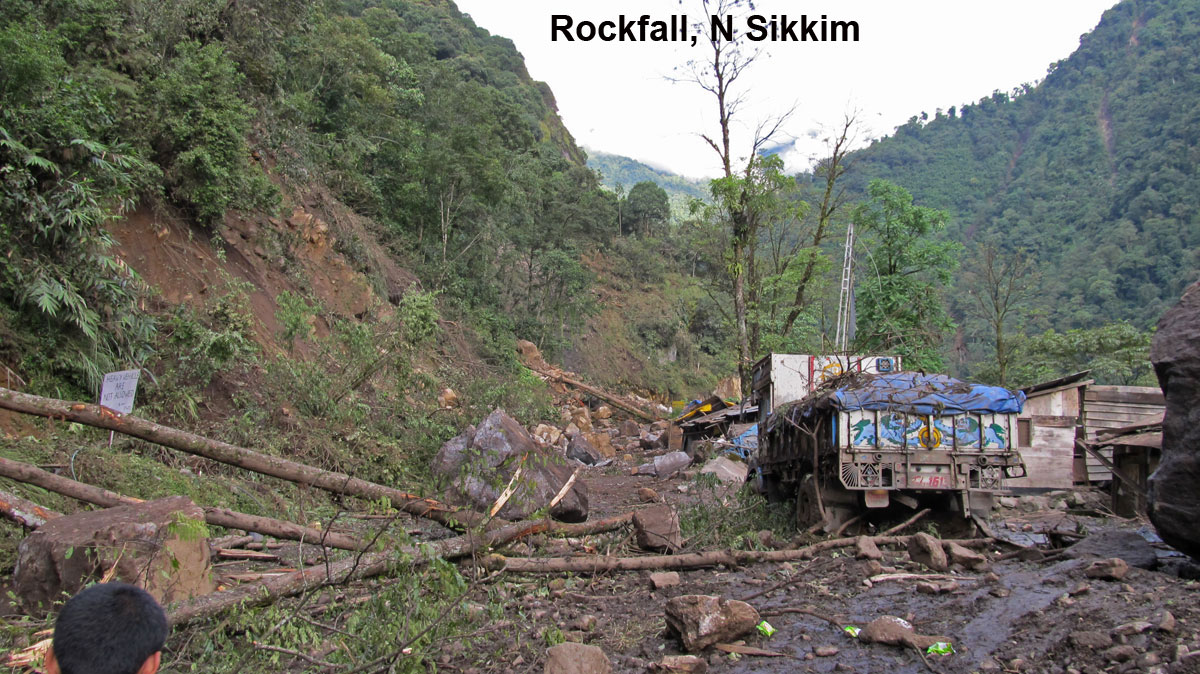
A strong earthquake of magnitude M: 6.8 shook Sikkim and Darjeeling areas of India and adjoining Nepal at 18.11 hours IST on 18Sept 2011 with its epicentre near the Sikkim-Nepal border, about 68 km northwest of Gangtok.
Placed above are some images of the region after the earthquake. You can read on the quake here (1, 2, 3)

Photo credit for Sikkim images: Tseten Lepcha 


Praful Rao,
Kalimpong,
Darjeeling district

Thursday, February 14, 2013

Lest we forget : Sikkim earthquake of 18Sep2011


We are still recovering from the reverberations of the Sikkim Earthquake five months after September 18th. We have during these months tried to understand what happened and to slowly rebuild our lives.
           Different places in Sikkim and elsewhere have suffered damages to different degrees, but it is Chungthang, headquarters of the Northernmost Subdivision of Sikkim, that is the “epicentre of damage”. As an engineer, the after quake visit to Chungthang has left a lasting impression on me. During our one day survey of damaged private houses, one question that kept cropping up in my mind and in the mind of other observers is “why is the damage so much greater in Chungthang than in other parts of Sikkim”. It seems as if a magnitude greater earthquake had struck Chungthang compared to the rest of Sikkim.
          Like countless others I have trawled through the net searching for information about the earthquake. Most websites agree about the size and type of the earthquake and that it originated somewhere near Kangchenjunga but there is very little other solid information.
Drawing circles on Google Earth with a 50 km radius centred at Kangchenjunga, Chungthang is just outside the hypothetical circle. Mangan, 42 km SE of Kangchenjunga, is the closest town to the epicentre and in the general direction of the fault orientation. That cleared up one other mystery as to why, during the post earthquake blackout of information, the rest of the world expected Mangan to be flattened and the news channels came to Mangan looking for “ground zero”. It left the main question unanswered.
         In Chungthang, I put this question to an eminent engineering professor from one of the IITs who had flown in privately to visit what he describes as a “living earthquake engineering laboratory”. He felt that the disproportionate destruction in Chungthang was due to the poor engineering and poor construction quality practice here.
        During our survey of the damaged structures, we found that the engineering of structures is as bad (or good) as anywhere else in Sikkim. Post earthquake surveys elsewhere have shown that properly engineered structures even if not designed for earthquake loads have withstood earthquakes much larger than the Sikkim Earthquake. The present state of practice in Sikkim is that very little analysis, design and detailed engineering is done in the preparation of the project. The mistry (mason) seems to have the final say in, for example, the size of the column and the reinforcement detailing. Computer analysis has made it easy to design even complicated structures and the relevant codes provide easy to follow rules for any engineering activity. Analysis and design and detailed engineering drawings should be as much part of the project as a plan and an estimate is at present.
         I talked to local people and Chungthang’s active civil society members about this. They felt that the large scale blastings during the construction of Teesta Stage III’s tunnels had weakened their structures prior to the earthquake. Their claims were supported by a report from the Department of Mines and Geology made prior to the earthquake. Tseten Lepcha of Chungthang tells me that the locals of Chungthang were actually in the process of demanding group insurance from Teesta III (a 1200 MW hydro project with dam at Chungthang) project authorities for all Chungthang structures when the earthquake happened.
         As an engineer with some geotechnical training, I have also tried to find answers in my field. The location of Chungthang town itself provides some clues. The town is constructed on a triangular river terrace at the confluence of the Lachen and Lachung Rivers. The river could have graded the soil it was carrying and deposited it loosely at Chungthang in the recent past. Locals also confirm that the water table is high because they find water close to the surface when they dig around here. In such conditions, if the earthquake shakes the soil for a longish duration, the ground can, like quicksand, loose all its strength. Engineers call this behaviour of soils “liquefaction”. Loose soils can also magnify the shaking in a phenomenon engineers call “soil amplification”.
        Moving away from Chungthang, “are the general observations made by us local people during the earthquake supported by science and engineering?” For instance, we saw that the shaking and damages were much greater along ridges and on hilltops in Sikkim. This is supported by research and surveys in other parts of the world. This is one of the reasons why monasteries and other religious structures which occupy commanding positions on ridges and hilltops were severely affected. Some other related observations and conclusions we have intuitively arrived at regarding the cushioning effect of soil seem contrary to research. As an example, engineers say soil does not cushion earthquake waves but in fact may amplify the shaking. Most of the rock outcrops are on ridges whereas most of the soil are in the hollows between ridges and could explain the seeming discrepancy between research and what we observe. We have to understand that most of the research on earthquakes or any other engineering/science discipline have been conducted in much flatter terrain.
         The earthquake has shown that we engineers have failed to provide enough inputs in our structures, whether Government owned or private. The earthquake provides us an opportunity to change and improve the way we build our structures. It also shows us that we need seismologists, geologists, structural and geotechnical engineers working together to understand what’s happened on September 18th in Chungthang and in Sikkim.

Credits :-
The above article was written in early 2012 for a local newspaper, five months after the 6.9 Sikkim Earthquake of 18Sep2011. The author Mr Pemzang Tenzin is an engineer by profession and also a farmer based in Mangan, Sikkim, India.
Photo credit :- Mr Deepak Sharma, Sikkim

Praful Rao