Showing posts with label himalaya. Show all posts

Wednesday, November 1, 2023

Photographic record (Part 1) of the impact of GLOF on parts of Teesta valley between Tar Khola and Dikchu - 22Oct2023

What we people living along the Teesta valley in parts of Sikkim and Kalimpong district, witnessed in the early hours of 04Oct2023 was a rare, dangerous and a huge catastrophe, the size and scale of which thus far has escaped the attention of the national media and many of us from Darjeeling - Sikkim Himalayas have also already forgotten it.  

When the very turbulent waters of the glacier lake outburst flood (GLOF) from South Lhonak glacier located at 17,300 feet crashed into the already brimming reservoir of the 1200MW Sikkim Urja Dam at Chungthang, the dam was quickly overwhelmed and crashed, releasing a wall of water which was 10-15 feet high. This deluge swept thru the Teesta valley, destroying everything in its 162km rampage from the glacier to Teesta Lo Dam Project at 27th Mile in Kalimpong district.
The path of the GLOF with distances and elevations are plotted in 3 maps below:

 
In order to preserve records of this historic disaster, STH has blogged extensively on the flooding. In continuation, on 29Oct2023, our small team consisting of Praveen (Junkeri Studios, Kalimpong) and I travelled to Dikchu (see route) to photograph the damage.

Tar Khola (27 07 53.1 N  88 30 6.4 E Elev: 264m)
The W Bengal side had a few families who lived on the river bank.
Rajesh Tamang (41yrs), one of the victims said that 20 of them would not be alive today had it not been for the intervention of the W Bengal police who forced them to move to higher ground. 9 homes were swept away here.
On the opposite (Sikkim) bank, Patel Engineering had a large complex which was constructing the power house for the Teesta VI dam which is at Sirwani near Singtam. The GLOF took away everything and the company has suffered damages to the tune of Rs250crores.
What is left of Patel Eng. complex at Tar Khola (Sikkim). Most of hardware and offices have been swept away by the GLOF (Drone images by Praveen).
Mangled remains of NHPC's bridge over the Teesta at Tar Khola. The bridge was swept away by the GLOF.
The pillars of NHPC's bridge over the Teesta at Tar Khola
Partly destroyed parts of the Patel complex from the opposite bank
The human suffering from a disaster. A husband and wife team digging out parts of what was their home at Tar Khola in order to perhaps find some documents, some valuables?
What the waters left behind - mud covered kitchen utensils in a home which was covered by the GLOF at Tar Khola.

Other places enroute to Singtam
We stopped by at small places enroute to SIngtam to record the impact of the disaster

Panchay Line
on NH10 (27 08 52.7 N  88 31 55.7 E) Elev: 266m
Prannay Tamang (42yrs) of Panchay line related a rare success story, worth emulating: they heeded to the first warning and left their home with their documents etc, they even evacuated their vehicles parked in the low lying areas. What is more the 6 pigs out of seven escaped from their sty and survived the GLOF.
Where the excavated sand is being dumped
(27 08 14.1 N 88 30 46.4 E)
Andheri on NH10 (27 09 57.5 N 88 31 55.3 E) Elev: 300m
Yogen Mangar (21yrs) student stands next to a massive tree trunk which the GLOF brought to his place while taking away his home.
Millions of tree stumps litter the banks of the Teesta river and are stuffed in every crevice possible (especially of dams).
Tree stumps in Teesta Stage VI dam at Sirwani, Singtam
One of the biggest destructive impacts of the GLOF must be on the forests of Sikkim and W Bengal.

The blog on our trip from Tar Khola to Dikchu being too long, I have divided it into Part I and Part II. This one covers only our trip upto Rangpo.
Part II (in a few days time) will cover Rangpo, Singtam and Dikchu


Praful Rao
Kalimpong district
Darjeeling -Sikkim Himalaya
savethehills@gmail.com
9475033744
with
Praveen Chhetri
Junkeri Studios
9733185815




Thursday, November 10, 2022

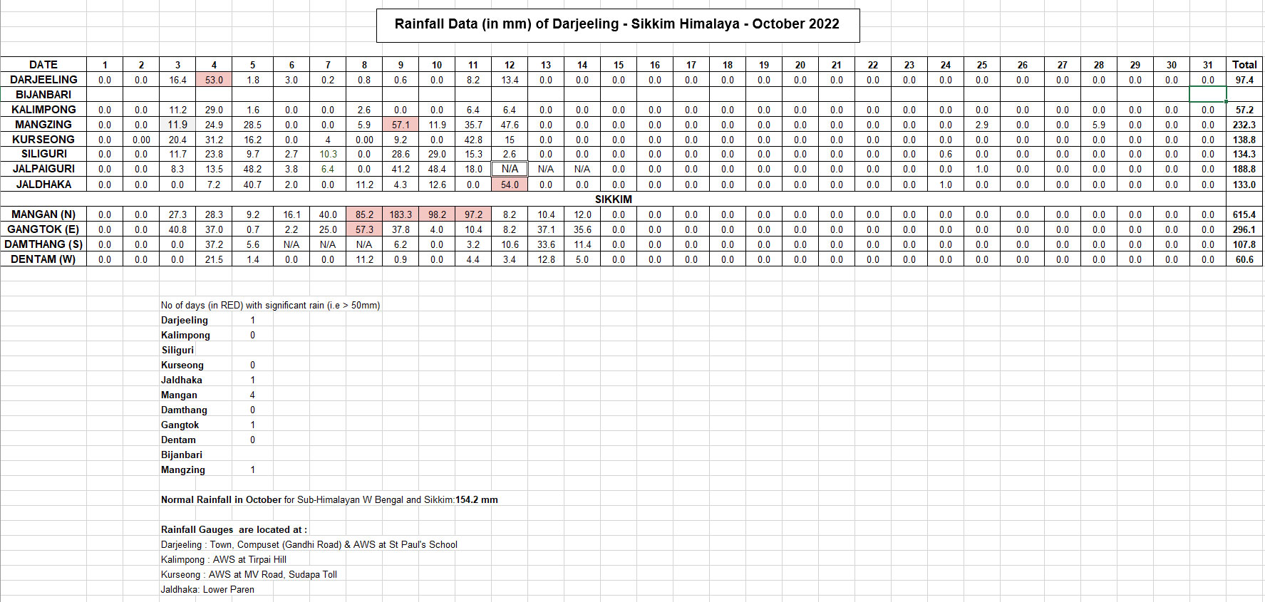
Rainfall data of Oct 2022 of some town in the Darjeeling - Sikkim Himalaya


As can be seen from the above table, Kalimpong, Darjeeling, South and West Sikkim had deficient rainfall while East and North Sikkim had excess rain. The plains of north Bengal including Siliguri had more or less normal rainfall.
The rainfall, however was confined to the first half of the month when the monsoons were quite active in the entire country even as the SW monsoons 2022 started withdrawing from the subcontinent. After 15Oct2022 there was no rain.


A series of low pressure areas formed in the Bay, some as remnants of tropical storms from the Pacific.
Remnants of tropical storm 'SONCA' formed a low pressure in the Bay which eventually intensified into Cyclone 'SITRANG' in the Bay of Bengal

SITRANG was the first cyclone to hit Bangladesh after 2017.

Media on Cyclone 'SITRANG' (Indian Express, 25Oct2022):

 Power and telephone links have been largely cut and coastal areas plunged into darkness, officials said.

A tropical storm that lashed Bangladesh left at least 35 people dead and about 8 million without power across the delta nation, officials and news reports said on Tuesday.

The government said about 10,000 homes were damaged and more than 6,000 hectares (15,000 acres) of crops were destroyed. Thousands of fishing projects were also washed away.

 The United News of Bangladesh news agency said about 20,000 people were marooned because of flooding triggered by tidal surges in the southern coastal district of Bhola.

Tropical Storm Sitrang brewed in the Bay of Bengal before turning north toward Bangladesh’s vast coast, prompting authorities to evacuate hundreds of thousands of people to cyclone shelters Monday. Heavy rains battered the country throughout the day, flooding many areas in the coastal regions across southern and southwestern Bangladesh.

Praful Rao
Kalimpong district
Darjeeling Sikkim Himalaya

Tuesday, August 2, 2022

Rainfall data of Jul2022 of some towns in the Darjeeling - Sikkim Himalaya

As per IMD, the southwesterly wind flow occurring over most parts of India and Indian Seas gives rise to southwest monsoon over India from June to September. The typical rainfall pattern over the Darjeeling-Sikkim Himalaya is shown below:

July is the month when our rainfall normally peaks, with the rains gradually decreasing thereafter.
The rainfall record of July2022 (day wise) of some towns of this region is  tabulated below:
You will notice that we have added rainfall data of
a. Mangzing (a remote village in Pokhriabong GP, Gorubathan block, Kalimpong district)
b. Bijanbari (Relling GP, Pulbazar block, Darjeeling district)
in our effort to map the rainfall of this region.
What is clearly evident is that the rainfall of July 2022 for many parts of the hilly regions of North Bengal and Sikkim was significantly below the normal monthly rainfall (615.8mm). Also for the first time in many years, Kalimpong rainfall exceeded that of Darjeeling.
What is also noticeable from the graph (Fig 1) is the towns mentioned had significantly higher rainfall in June than July which is an anomaly.
Fig1

July 2022 began with a large deficit in rainfall in the Sub Himalayan W Bengal and Sikkim regions however, the rains picked up a little in the third week of July. The paddy crop which is normally planted in July in rain flooded fields never happened in many places (Fig2).


 Fig 2
There was also very little activity in the Bay of Bengal and Pacific Ocean in this entire period  with hardly any typhoons forming in Pacific or low pressure areas in the Bay. A low which formed in Bay on 10July along with the rainfall deficiency is shown in Fig3:

 Fig3
Rainfall departures for July2022 for W Bengal and Sikkim are given below (Fig4)
Fig4
Rainfall was also deficient in South Bengal (Fig5)
 (Fig5)
Despite the deficit in rainfall, there were landslides especially along roads and NH10


Landslide at Reshi checkpost on NH717A (below Pedong (Kalimpong district) on 25July 2022.

Shreya Gurung
&
Praful Rao

Kalimpong district
Darjeeling Sikkim Himalaya

Sunday, January 30, 2022

Aug2021 Rainfall data of some towns in the Darjeeling and Sikkim Himalayas


Most stations had excess rainfall in Aug2021 even though the overall rainfall from the beginning of the monsoons till August end showed deficiencies in several districts.


Landslide occurrences for the month of August (and the other monsoon months) have been compiled in our presentation here

PS: Deep regrets for the delay in this report - it is just that STH uses another social media platform ie What's App 'Hazard Alerts 1 & 2' for reporting weather, rainfall, landslide activity and so on.
What's App is an extremely popular social networking tool in this part of the world and STH has been making use of it extensively for the last 4 years as a medium to report on disaster related information.


Shreya Gurung
Praful Rao
SaveTheHills
Kalimpong district
Darjeeling - Sikkim Himalayas

Monday, April 27, 2020

Tuesday, June 18, 2019

Flood scare in Sikkim and Kalimpong district (W.Bengal) - 17Jun2019


The Darjeeling - Sikkim Himalaya has thus far had very deficient in rainfall (see below)

 The SW monsoons finally arrived over the Darjeeling Sikkim Himalayas on 16Jun2019 almost 10 days late and we had relief from the heat here when there was a smattering of rainfall given by clouds shown:

Rainfall figures for 16/17Jun2019 are given (source IMD):

So I was rather surprised when we started getting flood alert messages from Sikkim on 17Jun afternoon on WhatsApp, that due to a 'cloud burst' in North Sikkim, the level of the Teesta river was rising dramatically and parts of Singtam (Adarsh Gaon), a business town one hour short of Gangtok and other low lying areas along NH10 were in danger.
Having kept a close look on the weather and rainfall of the region, which was nowhere near extreme, I personally feel that the dams at Chungthang and Dikchu in Sikkim had released large volumes of water after the rains which resulted in the Teesta river level rising sharply. I am aware that most of these dams are run-of-the-river dams, yet considering the steep descent path of the Teesta river and its turbulence, I do believe the volumes of water released caused the flood-like situation.
In this regard, I refer readers to the Youtube video below:


Updates on the above event:
Rainfall data of 17/18Jun (0830hrs to 0830hrs) available now:
Sankalan: 140mm
Mangan: 70mm
Chungthang: 50mm

(Source IMD)

Praful Rao,
Kalimpong district,
Darjeeling-Sikkim Himalaya


Wednesday, June 12, 2019

IMPACT: a photo-essay on impact of landslides in the Darjeeling-Sikkim Himalaya


Impact


IMPACT is a photo-essay done by a layman (yrs truly) for laypersons on the impact of landslides on human beings in this region. I have compiled the photos from a 11yr period (except for those shared by Das Studio, Darjeeling) and have woven my observations/comments on them.
It is by no means complete and will be continued. What I am extremely apologetic about is the lack of hard core data since I did not have access to district or state records on the huge impact of landslides on loss of life, land, compensation paid or of rainfall while making this presentation.
Regrets for that.
I also have not included any technical details of the landslides shown in the images simply because I have no access to them.


Praful Rao,
Kalimpong district,
Darjeeling - Sikkim Himalaya

Tuesday, April 9, 2019

STH activities : Raising awareness in Kalimpong on the menace of plastic waste (08Apr2019)

STH is a part of the Darjeeling Himalaya Initiative which in turn is the W Bengal state chapter of IMI

Praful Rao
Kalimpong district,
Darjeeling - Sikkim Himalaya