Showing posts with label chungthang. Show all posts

Saturday, March 22, 2025

Updated satellite images of Oct 2023 GLOF affected areas from Google Earth

Google Earth has recently (Jan2025) made available high resolution images of some areas of North Sikkim which reveal the devastating impact of the Glacial Lake Outburst Flood (GLOF) of Oct2023 in North Sikkim. The images below juxtapose the affected areas with historical snapshots, illustrating the catastrophic consequences of the GLOF.

Chungthang town / confluence of the Lachen and Lachung Chu

Chungthang (elevation 1790m/5870', 27.62°N 88.63°E), a town in North Sikkim, is situated at the confluence of the Lachen Chu and Lachung Chu rivers, which merge to form the Teesta river.
On October 3, 2023, an avalanche triggered a GLOF in South Lhonak glacial lake (elevation 5200m/17000'), approximately 75km upstream from Chungthang along the Lachen Chu. The resulting sudden release of around 50 million cubic meters of water made it the largest GLOF in the Himalayas in recent history.
For a detailed account of this event, refer to this publication in Science magazine
STH has closely documented the Teesta valley GLOF of Oct2023 in this blog from the date of occurrence.
Satellite images along with photos of the affected areas are placed below:-

Chungthang town (close up)

Chungthang town (Dec2024)
The still devastated playground and army camp area is seen at the center with the gilded dome of the Gurudwara towards the right side.
Chungthang town playground on 19Nov2023 when we visited the area.

The 1200mw Sikkim - Urja dam and bridge at Chungthang

This was the largest dam in Sikkim and was located downstream of the confluence of the Lachen and Lachung Chu rivers. The 60m rockfill, run of the river dam was commissioned in Feb 20217 at a cost of Rs 14,000crores. Along with the dam, a major bridge (centre top of photo) connecting Chungthang to the rest of Sikkim was also destroyed by the GLOF.
The remnants of Sikkim Urja dam which collapsed in the GLOF on 04Oct2023. Photographed on 18Nov2023, when we visited Chungthang.
A double laned concrete bridge connecting Chungthang to the rest of Sikkim was destroyed by the GLOF here on 04Oct2023

Munshithang (27.6324° N 88.6157° E)

Munshithang, an ammo depot for the Indian army was totally destroyed by the 04Oct Teesta Valley GLOF. On receiving warning of the rising waters in the Lachen Chu, 92 personnel of the ammo depot moved to  higher ground and thus their lives were saved. However, it was 4 days before they could be evacuated - due to bad weather which prevented helicopter flights.
Nothing could be retrieved of the ammunition and equipment lost to the GLOF.

Toong bridge over the Teesta river  (27°33'0.15"N 88°38'35.17"E)

We visited this area on 19Nov2023 and photographed the bridge and the Toong checkpost both of which were destroyed by the GLOF (below)
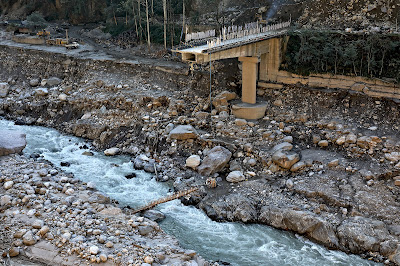
There was only a small bamboo bridge across the Teesta for pedestrians to cross the river on foot in Nov2023
The Toong police checkpost had been vacated and dangled precariously from the edge of the road
Another view of the vacated police checkpost in Nov2023
Faced with the sheer necessity of communicating, the local community start constructing a wooden bridge across the Teesta at Toong.

 Naga Gram Panchayat (Mangan district, North Sikkim)

Naga GP is located approx 14km from Mangan (district HQ of N Sikkim district) towards Toong and was one of the worst affected areas when we visited Chungthang on 19Nov2023.

It continues to be a wrecked and desolate place as can be seen from the recent photos (of Dec2024) below (photo credits: Rinchen Lama, IIHS ,Bangalore)
Google Earth has unfortunately not updated satellite images of areas south of Naga area (North Sikkim) which are still of 2022 vintage as such they do not show the impact of the GLOF in these areas.


Praful Rao
SaveTheHills
savethehills@gmail.com
9475033744

Wednesday, February 14, 2024

Impact of the Teesta Valley Glacial Lake Outburst Flood (GLOF) - updates from North Sikkim (Feb2024)

As has been reported by us in this blog, the GLOF disaster of Oct2023 devastated large parts of the Teesta valley both in Sikkim and W Bengal. Placed below are some recent updates from North Sikkim:
Naga area of Mangan district
The devastation in Naga and Toong area of Mangan district has been covered here.
Recent (09Feb2024) closeup photos of landslide affected areas of Naga are shown below:

A telephoto image of the same area which I took from the opposite hill on 18Nov2023 (below) reveals hardly any change in the intervening 3 months.

As per my source in Chungthang, people from these homes have evacuated and are living with relatives or at rented places.
Toong bridge and road status
The GLOF of 04Oct2023 destroyed the bridge over the Teesta river at Toong (see photo of 18Nov2023 below). This bridge connected Mangan (dist HQ of North Sikkim) with Chungthang

A 'log' bridge (below) built in this area has temporarily restored this communication route.
However, for the time being the bridge is closed between 10.00am to 4pm to allow road repairs as such commercial vehicles and others still have to route via a long route via Saffo- Shipgyer - this route not only takes double the time but is narrow and dangerous at places.
As per information received, the progress of repair of Chungthang - Mangan road and also the Chungthang - Lachen road is slow and this is worrisome since the pre-monsoon season accompanied by intense thundershowers are due to start in March 2024.
Here are some rough stats:
a. The freight charges for a truck with 10 tonnes of load from Siliguri to Chungthang was approximately Rs22,000/- (incl of taxes), when the main roads were available.
b. Now, since the main roads are not available, the detours have pushed up the freight charges to Rs 31,000/- and also the trucks can only carry 8-9 tonnes of material on the alternate route.
c. So because the freight charges have increased while the load which is being carried has decreased - a single brick in Chungthang now costs Rs18.
Chungthang town
Among all the urban centers impacted, the GLOF dealt it's severest blow to Chungthang town at around 12.35am on 04Oct2023. We have covered it in detail here
Even when we visited the town on 18Nov2023, more than a month after the devastation, the whole place still looked like a war zone but I am glad to know that the people of Chungthang are slowly getting back on their feet again. Placed below are recent images of Chungthang town where the almost 10 feet of sludge mud and sand which buried the streets, homes and buildings have been cleared off and shops are open and life is slowly getting back to normal.

Praful Rao
Kalimpong district
Darjeeling- Sikkim Himalaya
savethehills@gmail.com
9475033744

Wednesday, December 13, 2023

BBC covers what the Indian National Media missed: The 04Oct2023 GLOF disaster in the Teesta valley

The BBC has today covered the 04Oct2023 GLOF disaster in the Teesta valley here and although the report by Cherylann Mollan, Mumbai has many glitches and errors, I welcome BBC's coverage merely because the National Media has covered it too sketchily or missed it out altogether and the Central and State Governments of Sikkim and W Bengal seem to think the GLOF incident was too insignificant, affecting too few to be bothered about.
Of the many errors in the report, I can point out a few glaring ones:

  • The 04Oct2023 disaster has somehow been named the 'Sikkim flood disaster' which precludes large downstream areas in Kalimpong district (W Bengal) which were also badly affected by the GLOF. This has been made worse by W Bengal government not even considering the event, a disaster.
  • In all probability, what triggered the GLOF was a large landslide or an avalanche and NOT a cloud burst as mentioned by the BBC. Read here
  • The GLOF which started from South Lhonak Lake (elevation approx 17,300') late in the night of 03Oct2023, wrecked many areas around Lachen but the first major town (not nearby village) it devastated was Chungthang (elevation 5,500') approximately 62km downstream and where the Sikkim Urja Stage III 1200MW dam was located. The dam was destroyed by the GLOF which hit Chungthang at 12.35am on 04Oct2023.
    What remains of the 1200MW SIkkim Urja StageIII dam at Chungthang (Photo date: 18Nov2023)

We were in North Sikkim between 17-19Nov2023 and our reports on the devastation in Chungthang town and its vicinity may be read here
Drone photo of devastation in Chungthang town (Photo date:18Nov2023)

I totally agree with Mathew Payne's (the School of Geography, Geology and the Environment at the University of Leicester) statement in the BBC article:

"This catastrophe is a stark reminder of the escalating challenges faced by the verdant Himalayan regions and the increasing magnitude of flooding events necessitates resilient infrastructure capable of tolerating climate-induced excessive rainfall"

which is why we emailed our report and recommendations on the 'Teesta valley GLOF disaster'  to the NDMA and SDMA's of Sikkim and W Bengal on 10Nov2023. The recommendations are essentially short term, aimed at tackling the Monsoons of 2024 which are just 3 months away.

We are yet to receive any reply to our report.

My thanks to BBC for this report on the 04Oct2023 Teesta Valley GLOF disaster.


Praful Rao
Kalimpong district
Darjeeling-Sikkim Himalaya
savethehills@gmail.com
0475033744

Sunday, November 26, 2023

Photographic record of the impact of 04Oct2023 GLOF at Chungthang (North Sikkim) and its vicinity.

Chungthang (Lat 27 36 13.3 N Long 88 38 43.5 E, Elevation:1612.5m) is a small town (population around 4000) in North Sikkim located at the confluence of Lachen Chu ('Chu' means 'Water' in Tibetan) and Lachung Chu. It was also where the Sikkim Urja (Teesta III) dam, a 1200MW, 60 M high Concrete Faced Rockfill Dam (CFRD) was built - it was commissioned in Feb 2017. The dam was the largest run of the river project in the region and the power house was located downstream at Singhik village.
Sikkim Power Investment Corporation Limited (SPICL), a 100% wholly owned public limited company of Government of Sikkim, is the holding company of the project.
The growth of Chungthang between 2006 and 2020 is shown below:

In this regard, quoting from The Sikkim Tourism Development Corporation (STDC) website: 'With the recent hydropower development in the area, the landscape of Chungthang is changing rapidly and is becoming a major settlement in North Sikkim.'
The glacial lake outburst flood (GLOF) from South Lhonak glacier in the late hours of 03Oct2023, released a massive volume of water along Lachen Chu which deluged and engulfed almost the whole of Chungthang at around 12.30am on 04Oct2023. It took down the double lane concrete bridge at Chungthang after sweeping away at least 3 bridges towards Lachen and one bridge across the Lachung Chu.
Amidst the rain, roar and rumble of the river and pitch dark conditions no one is precisely sure when the Teesta III dam collapsed but it did so sometime during the night. It was only on the next day that everyone in Chungthang became aware of the horror and scale of devastation.
The GLOF and the dam collapse caused an unprecedented disaster all along Teesta river valley which SaveTheHills has been documenting since 04Oct2023.
We were in Chungthang for the entire day on 18Nov2023 and talked to many affected people while photographing the disaster - besides just being awed at the raw and vicious power of nature.


What remains of Sikkim Urja (Teesta III), 1200MW dam


Drone image from Chungthang town looking down stream.
The magnitude of nature's forces involved is evident from the giant boulder which has been hoisted to that height and parked in a slot.
Drone image of the dam looking upstream; Chungthang town is in the distant with Lachen Chu on the left and Lachung Chu on the right. The extent of damage is visible even from far.
Satellite image of the dam

This was where Sikkim Urja (Teesta III) dam had its entire office setup. The GM's office and other residential quarters were also here. The surging waters swept away all and left behind some trash and gigantic boulders.
Gigantic rock formations have emerged after the GLOF gouged out all the earth on top (which now form the sand and sludge deposits downstream). The massive boulder clogging up a dam structure can be seen in the background.
Parts and machinery from the Stage III dam now litter the river bed at Chungthang.

The 'GLOF Only' areas. 

By this we mean, areas upstream along Lachen Chu river where the dam burst did not have any impact and the destruction was caused solely by the GLOF from South Lhonak lake.
It was surprising (and scary) to see the amount of damage which had been caused by the GLOF alone. In the distant one can see the ITBP colony where the road to Lachen seen on the right ends.
The damage caused by only the GLOF from South Lhonak lake is huge as can be seen.This drone image reveals the scouring of the river bed caused by the violent waters just a few kilometers towards Lachen from Chungthang.
The impact on Lachen Chu river bed by the GLOF approx 2 km north of Chungthang is seen here. The road to Lachen is only upto the ITBP colony seen in the distant.
Close up of the damage caused by the GLOF alone. A bridge to Lachen has been torn down here (27 36 47.4 N 88 37 47.2 E), further north 2 more bridges have been destroyed by the GLOF, numerous power pylons and towers have been damaged. Army personnel in areas around Lachen reported strong vibrations during the event.
This is where the road to Lachen ends (27 36 42.7 N  88 37 51.4 E) Elev 1705m (Drone image).

Impact on Government assets

Sikkim Government assets located towards the southern tip of Chungthang town were severely damaged by the GLOF
The Legal cell building at Chungthang on 18Nov2023
The SIB office at Chungthang.
The shredded Police Station (Thana) at Chungthang is on the right. A huge truck has been neatly shoved into an office in the thana by the GLOF as if someone had parked it inside. The Chunthang Fire department building, Sikkim Tourism Department guest house has also been extensively damaged in this area.
ITBP shacks along the Lachung Chu which were buried by the backflow from the GLOF. This river was otherwise not affected by the event. Notice this river has turned green as it is winters now - surprisingly, the Lachen Chu is still loaded with silt and brownish. A bridge further up was destroyed by the backflow.
The Chungthang playground and stadium which were deluged by the GLOF.
The army lost a lot of assets  in this area - fortunately no life was lost.
A rifle rack from the Sikkim Police Station (Thana) with the weapons swept away by the swirling waters, at the dam site.
This, along with the loss of army assets adds another dimension to the safety of our riverine areas and even dams.

Chungthang town

The GLOF of 04Oct2023, left the tiny town of Chungthang on its death throes. The midnight floods affected almost every part of the town and the only sounds audible, when we visited Chungthang on 18Nov2023, were the grinding and clanking of heavy machinery as the residents tried to excavate their homes and get their lives back together.
More than 54 RCC buildings and homes were damaged by the floods, many smaller wooden homes and shacks were simply swept away. Also what was lost were countless Buddhist artifacts, monuments and antiques which every affected home had and which the floods snatched away.
A school was destroyed in the centre of town.
Drone image of Chungthang town on 18Nov2023, showing the extent of damage by the GLOF.
Satellite image of the above area.
On the left, Lachen Chu or the Teesta river flows downstream and a Bailey bridge has been  constructed by the army engineers on 16Nov2023 at 'A' above which allows some sort normalcy of movement and supplies coming into the town.
Drone image showing the devastation wrought by the GLOF in areas adjacent to the river bank.
Drone image from the road to Lachen showing erosion of the river bank adjacent to Chungthang town. In the foreground are areas where there were several army installations.
Satellite image of the playground area of Chungthang town.
The town on 18Nov2023. Massive rocks are strewn all over and 10-15 feet of sludge plasters much of the town area.
An army truck has been parked inside a room by the GLOF. Notice the level to which the flood waters reached.
Chungthang on 18Nov2023.
The gilded dome of Gurudwara Nanak Lama Sahib is seen in the background.
The Gurudwara and its staff provided and continues to provide extraordinary service to the denizens of Chungthang. The ground floor of the Gurudwara was inundated by the GLOF and the staff evacuated temporarily to return quickly and provide food and shelter to thousands of people. While we were in Chungthang, 70 odd homeless people were staying in the complex and everyday 3 - 4000 meals were being provided to anyone who wanted food.
Photo of 05Oct2023 showing removal of sludge and debris in front of the Gurudwara at Chunthang (Photo credit: Lhendup Lepcha)
Officials of the Sikkim Government conducting a survey on losses to homes and property at Chungthang. They said government engineers were also testing the structural stability of damaged buildings. With much of the town in ruins, this process will take some time to complete.

The Rivers and the Environment

Photo of 05Oct2023 shows a gap where there was a double lane concrete bridge over the Teesta at Chungthang. It was taken down by the GLOF. (Photo credit: Lhendup Lepcha).
A tiny bamboo bridge over the Teesta for ferrying men and material before the current Bailey bridge (below) was completed by army engineers.
Photo of 18Nov2023 shows a bridge across the same spot, which army engineers put across the Teesta on 16Nov2023..
The armed forces have always taken a lead role in helping out in all disasters and so it was in Chungthang in Oct2023 where they were instrumental in providing warning, evacuating tourists and saving lives and the civilians in Chungthang I talked to gratefully acknowledged this.
Photo of 07Oct2023 showing army/BRO/ITBP/ and other people trying to put a ropeway across the Teesta at Chungthang.The river was again in spate and there was light rain as such the effort was abandoned.(Photo credit: Lhendup Lepcha)
Heavy road construction machines and men of the BRO working on the road towards Lachen.
(Photo credit: Lhendup Lepcha)

The completion of repair of the Chungthang - Lachen road may take anywhere from 3 - 6 months and right now Lachen is connected to Zema and Thangu only by a temporary bridge. The people of these areas will require extensive help to face the harsh winters ahead.

All in all, I am amazed at the scale and ferocity of nature's revenge.

My humble thanks to all who helped.

Praful Rao
Kalimpong district
Darjeeling-Sikkim Himalaya
savethehills@gmail.com
9475033744

with

Praveen Chhetri
Junkeri Studios,
Kalimpong
junkeristudio@gmail.com
9733185815