Showing posts with label farming community. Show all posts

Monday, September 12, 2022

Tanyang, a village on the edge (11Sep2022)

Tanyang, a tiny village (in Samalbung GP, Kalimpong 1) composed almost entirely of people from the Lepcha community is approximately 2hrs drive from Kalimpong. It is a village of farmers and as such, land being their most precious asset, the loss of 10-12 acres of land due to the landslides creates a huge dent on the earnings and livelihoods of the people.
I was rather surprised to hear of a recent landslide in the village because of the mild summer monsoons this year and a deficiency in rains in July and August 2022.
We were in the landslide affect areas adjoining the main village yesterday where we did a drone survey of the landslide.
A Google - Earth image of the landslide dated 1/1/2021 is placed below:

The local people, who are often the best judges, offered various reasons for the cause of the landslide:
  • It was initially triggered during the major landslide disaster of Oct 1968, which is totally believable since many of the old landslides started with this event.
  • Some of the villagers said it was the Sep2011 Sikkim earthquake which had created the cracks and the fissures.
  • Everyone seemed quite sure that the heavy rainfall on 26Aug2022 had caused the recent landslides which necessitated the evacuation of 10 families from the immediate vicinity of the landslide.
  • Some said water was oozing out from inside the slide which probably caused the slide.
  • One could safely rule out human activity as a probable cause. There is no urban built up areas here, population is low, no major road construction or other developmental activity. No jhora nearby which could have caused the erosion and the river at the base of the mountain is quite far and could not have caused toe erosion.
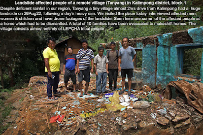
     
     
    10 families, including women and children had been evacuated and were housed in temporary structures and also in the ICDS building

When interviewed the women folk especially were apprehensive of the future and wanted to be relocated close by somewhere and quickly since the future of the family and children were at stake. 

 Media report of the landslide is placed below:
The link to the drone footage and interviews will be put up as soon as it is ready.

Praful Rao
Kalimpong district
Darjeeling Sikkim Himalaya

Tuesday, April 5, 2016

Rainfall data of March 2016 and our dying springs.


Though the rainfall maps (top) and the data (above) indicate that the shortfall in precipitation has decreased (from around 80% to 14%) in March 2016, this does not represent the facts on the ground where changing rainfall patterns have resulted in winter rains almost vanishing. So what we have these days is an alternating cycle of abundant rain (5 months in the monsoon period) followed by 6-7 bone dry months.
In this situation, Kalimpong town is today facing an acute potable water crisis - water from the Govt PHE source is supplied only to certain parts of town that too, once in 6 days. The rest of the town and all hotels, many schools and homes are forced to buy water.
But it is in the rural areas all over the Himalayas that a major problem is looming with many natural springs drying up. In Almorah (Uttarakhand) the number of natural springs has dwindled from 350 to 60 in the span of 150yrs.
Some of the obvious reasons for this decline, besides the changing rainfall patterns are:-
  • Developmental activities in the mountains such as road construction and massive urbanization has resulted much of the rain water flowing off as surface run-off rather than percolating into the soil and recharging the aquifers.
  • Declining forest cover again enhances surface run-off whereas vegetation would reduce run-off and augment aquifer recharge.
Recently, in Sikkim there has been a government intervention at springshed management which have shown positive results but we will have to wait for the long term benefits of this initiative. Elsewhere, villagers are left to fend for themselves as far as finding water sources are concerned and to check the extent of the problem STH carried out a survey in a rural area (Bhalukhop village) on the western face of the Kalimpong ridge line (see map below).
 My guide for the survey of the health of springs in Bhalukhop was Man Bahadur Darji, 57, a denizen of Rai Gaon, Bhalukhop. The results are placed below in images, with coordinates of the springs in each image:-


Praful Rao,
Kalimpong,
Dist Darjeeling