Showing posts with label mangan. Show all posts

Friday, July 3, 2020

A pictoral record of the landslides of JUN 2020 in Darjeeling-Sikkim Himalaya


Shown above are the approx timelines when due to the more than normal rainfall in Jun2020, there were numerous landslides in the Darjeeling - Sikkim Himalayas and all occurred during periods of heavy rain. For example, in 6 days (17Jun-22Jun2020) Kalimpong received approx 78% of its monthly rainfall which is when all the landslides in Kalimpong took place.
More specifically:
a. Darjeeling and Kurseong area had landslides just as the SW monsoons entered the region on 12/13Jun 2020. Many of these landslides are documented here.
b. Kalimpong district which had almost no rain during this onset period, had intense rain on 17Jun which triggered a number of slides in the district.
c. Mangan (N Sikkim) and E Sikkim were the only places which had surplus rain over the winter months and continued to have very heavy rain towards June end and that triggered a number of landslides.
In order to maintain a record of the landslide events I am posting verified photos of some of them as submitted by HA members.

Kalimpong:
North Sikkim (Passingdang)
North Sikkim (District HQ: Mangan)27.4979° N, 88.5348° E

North Sikkim (Barfok)
27.509787°N, 88.437531°E
Debris Torrent as seen from across the Teesta from Mangan. No loss of lives, some houses evacuated.

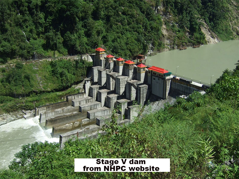
Landslide at NHPC Stage V 510 MW Dam at Dikchu, East Sikkim


Landslip on Dhotrey- Maneybhanjang road (22Jun2020?)
Rimbick- Lodhoma landslide (28Jun2020)
at Chota Hatta, Kankeybong.

Breaches on NH55 (Siliguri to Darjeeling) near Pagla Jhora (Kurseong)
30Jun2020


My sincere thanks to all those who have volunteered their time and effort in 'HAZARDS ALERTS' (Whats App group)  and elsewhere to provide the information and photographs for the above record.

Praful Rao
Kalimpong district
Darjeeling Sikkim Himalaya


Tuesday, April 5, 2016

Rainfall data of March 2016 and our dying springs.


Though the rainfall maps (top) and the data (above) indicate that the shortfall in precipitation has decreased (from around 80% to 14%) in March 2016, this does not represent the facts on the ground where changing rainfall patterns have resulted in winter rains almost vanishing. So what we have these days is an alternating cycle of abundant rain (5 months in the monsoon period) followed by 6-7 bone dry months.
In this situation, Kalimpong town is today facing an acute potable water crisis - water from the Govt PHE source is supplied only to certain parts of town that too, once in 6 days. The rest of the town and all hotels, many schools and homes are forced to buy water.
But it is in the rural areas all over the Himalayas that a major problem is looming with many natural springs drying up. In Almorah (Uttarakhand) the number of natural springs has dwindled from 350 to 60 in the span of 150yrs.
Some of the obvious reasons for this decline, besides the changing rainfall patterns are:-
  • Developmental activities in the mountains such as road construction and massive urbanization has resulted much of the rain water flowing off as surface run-off rather than percolating into the soil and recharging the aquifers.
  • Declining forest cover again enhances surface run-off whereas vegetation would reduce run-off and augment aquifer recharge.
Recently, in Sikkim there has been a government intervention at springshed management which have shown positive results but we will have to wait for the long term benefits of this initiative. Elsewhere, villagers are left to fend for themselves as far as finding water sources are concerned and to check the extent of the problem STH carried out a survey in a rural area (Bhalukhop village) on the western face of the Kalimpong ridge line (see map below).
 My guide for the survey of the health of springs in Bhalukhop was Man Bahadur Darji, 57, a denizen of Rai Gaon, Bhalukhop. The results are placed below in images, with coordinates of the springs in each image:-


Praful Rao,
Kalimpong,
Dist Darjeeling

Saturday, September 5, 2015

Rainfall data of Darjeeling and Sikkim : Aug 2015


Gangtok, Darjeeling and Kalimpong had deficient rainfall in Aug2015 whereas Kurseong and Mangan (N Sikkim) had an excess in rainfall.
Excess rainfall seen in S Bengal was the aftermath of Cyclone Komen which formed in the Bay, end of July2015. No other significant system affecting our region formed in the Bay of Bengal in Aug2015.
There were no major landslides or fatal landslides in Darjeeling and Sikkim.

Praful Rao,
Kalimpong,
Darjeeling district

Saturday, May 4, 2013

Rainfall data of Darjeeling district and N Sikkim - April 2013


The pre-monsoon season in India lasts from Mar- May and as per the above map from IMetD we are running deficient in rainfall.
STH has installed a new ARG in Mangan (N Sikkim) but regretfully the ARG at Jaldhaka in the foothills of the Dooars has become unserviceable.

Praful Rao,
Kalimpong

Tuesday, April 30, 2013

Images from North Sikkim (13-16Apr2013)


On 18Sep2011 (Sunday), at approx 18.10h IST a 6.8R earthquake rattled much of Sikkim and Darjeeling district.
That very few died was an absolute miracle especially since the quake struck us at the end of the monsoons (when the ground was saturated with water) and that it had rained the whole of Sunday morning.
I have covered the impact of the quake elsewhere in the blog but never had the opportunity to visit North Sikkim where it was epi-centred.

In mid-April 2013, I had visited Mangan (dist headquarters of N Sikkim) and journeyed upto Lachung. While being awed by the amazing beauty of the place, I was totally shocked to see the scale of devastation wrought by the quake even after almost two years. 
The condition of the road from Mangan upto Lachung is appalling with landslides lacerating it at numerous places and magnificent forests of rhododendrons have been decimated by slides enroute to Yumthang ; little wonder then that any heavy spell of rainfall reactivates these slides.
Placed above is a photo essay from my recent visit to this wonderland.


Praful Rao,

Kalimpong

Thursday, February 14, 2013

Lest we forget : Sikkim earthquake of 18Sep2011


We are still recovering from the reverberations of the Sikkim Earthquake five months after September 18th. We have during these months tried to understand what happened and to slowly rebuild our lives.
           Different places in Sikkim and elsewhere have suffered damages to different degrees, but it is Chungthang, headquarters of the Northernmost Subdivision of Sikkim, that is the “epicentre of damage”. As an engineer, the after quake visit to Chungthang has left a lasting impression on me. During our one day survey of damaged private houses, one question that kept cropping up in my mind and in the mind of other observers is “why is the damage so much greater in Chungthang than in other parts of Sikkim”. It seems as if a magnitude greater earthquake had struck Chungthang compared to the rest of Sikkim.
          Like countless others I have trawled through the net searching for information about the earthquake. Most websites agree about the size and type of the earthquake and that it originated somewhere near Kangchenjunga but there is very little other solid information.
Drawing circles on Google Earth with a 50 km radius centred at Kangchenjunga, Chungthang is just outside the hypothetical circle. Mangan, 42 km SE of Kangchenjunga, is the closest town to the epicentre and in the general direction of the fault orientation. That cleared up one other mystery as to why, during the post earthquake blackout of information, the rest of the world expected Mangan to be flattened and the news channels came to Mangan looking for “ground zero”. It left the main question unanswered.
         In Chungthang, I put this question to an eminent engineering professor from one of the IITs who had flown in privately to visit what he describes as a “living earthquake engineering laboratory”. He felt that the disproportionate destruction in Chungthang was due to the poor engineering and poor construction quality practice here.
        During our survey of the damaged structures, we found that the engineering of structures is as bad (or good) as anywhere else in Sikkim. Post earthquake surveys elsewhere have shown that properly engineered structures even if not designed for earthquake loads have withstood earthquakes much larger than the Sikkim Earthquake. The present state of practice in Sikkim is that very little analysis, design and detailed engineering is done in the preparation of the project. The mistry (mason) seems to have the final say in, for example, the size of the column and the reinforcement detailing. Computer analysis has made it easy to design even complicated structures and the relevant codes provide easy to follow rules for any engineering activity. Analysis and design and detailed engineering drawings should be as much part of the project as a plan and an estimate is at present.
         I talked to local people and Chungthang’s active civil society members about this. They felt that the large scale blastings during the construction of Teesta Stage III’s tunnels had weakened their structures prior to the earthquake. Their claims were supported by a report from the Department of Mines and Geology made prior to the earthquake. Tseten Lepcha of Chungthang tells me that the locals of Chungthang were actually in the process of demanding group insurance from Teesta III (a 1200 MW hydro project with dam at Chungthang) project authorities for all Chungthang structures when the earthquake happened.
         As an engineer with some geotechnical training, I have also tried to find answers in my field. The location of Chungthang town itself provides some clues. The town is constructed on a triangular river terrace at the confluence of the Lachen and Lachung Rivers. The river could have graded the soil it was carrying and deposited it loosely at Chungthang in the recent past. Locals also confirm that the water table is high because they find water close to the surface when they dig around here. In such conditions, if the earthquake shakes the soil for a longish duration, the ground can, like quicksand, loose all its strength. Engineers call this behaviour of soils “liquefaction”. Loose soils can also magnify the shaking in a phenomenon engineers call “soil amplification”.
        Moving away from Chungthang, “are the general observations made by us local people during the earthquake supported by science and engineering?” For instance, we saw that the shaking and damages were much greater along ridges and on hilltops in Sikkim. This is supported by research and surveys in other parts of the world. This is one of the reasons why monasteries and other religious structures which occupy commanding positions on ridges and hilltops were severely affected. Some other related observations and conclusions we have intuitively arrived at regarding the cushioning effect of soil seem contrary to research. As an example, engineers say soil does not cushion earthquake waves but in fact may amplify the shaking. Most of the rock outcrops are on ridges whereas most of the soil are in the hollows between ridges and could explain the seeming discrepancy between research and what we observe. We have to understand that most of the research on earthquakes or any other engineering/science discipline have been conducted in much flatter terrain.
         The earthquake has shown that we engineers have failed to provide enough inputs in our structures, whether Government owned or private. The earthquake provides us an opportunity to change and improve the way we build our structures. It also shows us that we need seismologists, geologists, structural and geotechnical engineers working together to understand what’s happened on September 18th in Chungthang and in Sikkim.

Credits :-
The above article was written in early 2012 for a local newspaper, five months after the 6.9 Sikkim Earthquake of 18Sep2011. The author Mr Pemzang Tenzin is an engineer by profession and also a farmer based in Mangan, Sikkim, India.
Photo credit :- Mr Deepak Sharma, Sikkim

Praful Rao


Monday, September 24, 2012

From Sikkim today : 24Sep2012


Photo credits : Mr Wangchuk Dorjee
                    : Mr Chewang Lepcha


Praful Rao