SaveTheHills(STH) is a group of concerned citizens who are raising awareness about landslides in Darjeeling-Sikkim Himalaya. Many landslides are the direct or indirect result of human interference and preventable if sufficient care is taken. As such, unless we begin a comprehensive and sustained program towards landslide management, prevention and mitigation, the consequences of ignoring years of human callousness will, in the future be devastating.
Tuesday, July 21, 2026
Heavy rainfall event: Targeted rainfall over Kalimpong town and its immediate surroundings on 21Jul2026
The type of rainfall Kalimpong witnessed last evening and which continued for the whole of this morning (21Jul2026) was what we expect during the month of July in this region...steady and continuous rain which can turn heavy at times.
There was no thunder or lightning, just the steady drumbeat of heavy rain for hours on end. The graph above shows just that with the rainfall intensity remaining above 50mm/hr for much of the time.
That was not surprising, what was very surprising to me was the fact that the rainfall was very targeted and confined, affecting only Kalimpong town and a small area in its vicinity. The map below reveals this and rainfall figures above 100mm are in RED.Darjeeling received 74.2mm of rain and Kurseong which normally receives the heaviest rain among the hill towns received only 51.4mm. The rainfall figures in black are all below 50mm.
The Infra-Red (IR) cloud imagery (below) of this region of 06.15am today shows nothing which could have caused such heavy rain over Kalimpong while causing only 9.6mm over Siliguri and 8.3mm over Gangtok.
The rainfall caused a small urban landslide near my home in Tirpai Kalimpong this morning. The drone image of the landslide is placed below (27° 4' 37.308" N 88° 29' 17.43" E - drone lat/long). Do notice the densely packed homes which seems to be the direction in which every mountain town in the Himalayas is heading.
Praful Rao
SaveTheHills
savethehills@gmail.com
9475033744
Monday, November 18, 2024
Community-Led Call to Action: 290 Signatures urging Immediate Disaster Mitigation in the Teesta Valley submitted by Darjeeling Himalaya Initiative and SaveTheHills
The following memorandum signed by 290 persons from Kalimpong, Darjeeling, and Sikkim has been submitted by Darjeeling Himalaya Initative and SaveTheHills to the Chairs of the NDMA, SDMA W Bengal and SDMA Sikkim:
_______________________________________
The Teesta Valley GLOF Disaster of October
2023: Impacts and Urgent Mitigation Needs Ahead of the 2025 Monsoons.
The Glacial Lake Outburst Flood (GLOF) and
the subsequent hydro-power dam breach in the Teesta Valley in October 2023
brought widespread devastation, leading to tragic loss of life, severe damage
to livelihoods and assets as well
unaccounted ecological devastation across Sikkim and West Bengal.
The disaster caused significant destruction to the National
Hydroelectric Power Corporation’s (NHPC) infrastructure, agricultural land,
forests, riverine ecosystems, transportation routes, and even critical military
installations (Much of the devastation caused by the GLOF is documented in
SaveTheHills’ blog http://savethehills.blogspot.com) Yet, despite the scale of
the disaster, the response from state and central authorities have been
inadequate, especially long term rehabilitation and restoration interventions
at the relief, infrastructure and ecological level.
To further elucidate, we cite the case of fifty six families in the Teesta
Valley (Kalimpong district) who were displaced
by the floods in Oct2023 and still continue to reside in relief centres. For
these people who depended on the river for their survival, displacement has
worsened their economic stability, and every day existence becomes a struggle
for survival. Prolonged uncertainty worsens their mental distress, highlighting
the urgent need for targeted interventions to restore their houses and
livelihoods.
NH10, the lifeline of Kalimpong and Sikkim remained perilously unstable for
much of the monsoons season and diversion of traffic from Sikkim via alternate
routes added avoidable burden on transport services, infrastructure as well as
the communities along the route.These vulnerabilities were exposed again almost
throughout 2024 monsoon season and has severely reduced the tourist traffic to
the region impacting the economy of the
Sikkim and Darjeeling Himalaya.
With only six months remaining before the 2025 monsoon,
there is an urgent need to implement both structural and non-structural
mitigation measures throughout the Teesta Valley. Effective action now can
significantly reduce the impact of future floods, as such the implementation of
these measures both in Sikkim and West Bengal in the valley is a vital necessity.
Central assistance will be imperative simply because the scale and complexity
of the problem cannot be tackled at the state level.
The important issues at hand are listed below:
The Case for a Joint Sikkim-West Bengal Committee on Teesta Valley Flood Management
The October 2023 GLOF was one of the most severe glacial
floods in the history of the Himalaya, affecting both Sikkim and West Bengal
and needs to be responded to at a landscape level that is inclusive of both
states. Each monsoon season, the Teesta River poses serious threats to both
states, making collaborative management of the river and its surrounding
regions essential.
A joint committee from both the states could address common issues and
implement coordinated disaster management strategies that benefit both states.
Formation of an Expert Task Force
A dedicated task force of experts, drawn from geo-hydrology, environmental science, engineering, and sociology, should be formed to tackle the many challenges brought about by the GLOF. This task force must develop a comprehensive action plan that includes technical, financial, and social solutions for restoring and fortifying the region.
Structural Mitigation Measures
Construction of Embankments, Protection Walls, and Barriers
Embankments and barriers are urgently needed in low-lying,
high-risk areas to prevent river overflow into settlements. Populated areas in
the valley which are particularly vulnerable to flooding such as those below the Teesta bridge along the
Darjeeling-Kalimpong road, must be identified and remedial engineering
solutions applied.
Channeling the River Flow
The natural flow of the Teesta River was disrupted by debris buildup from the GLOF, leading to riverbank overflow. The river must be re-channelized to prevent further damage to urban areas and infrastructure. Experts in fluvial geo-morphology and hydrological engineering can assist in deepening, widening, and redirecting the river to safer channels. NHPC’s technical expertise can be instrumental in this effort.
Road Engineering and Restoration
NH10, the key highway linking Siliguri and Gangtok, suffered extensive damage during the GLOF, resulting in economic losses and supply chain disruptions. Immediate restoration of this critical artery must be prioritized, along with repairs to alternative routes that have also deteriorated due to increased traffic and monsoonal impacts.
Bridge Repair and Reconstruction
The destruction of bridges in Sikkim and West Bengal has cut off many communities, hindering both economic activity and disaster relief efforts. Repair and reinforcement of these vital structures must be completed before the next monsoon season.
Reinforcement of Evacuation Centers and Relief Camps
Many evacuation centers and relief camps need urgent repairs and enhancements, such as backup solar power, to ensure they remain operational in the event of future emergencies.
Non-Structural Mitigation Measures
Early Warning Systems (EWS) and Communication Networks
Installing automated flood early warning systems (FLEWS) that deliver real-time alerts through sirens and mobile networks is crucial. Backup communication methods, such as ham radios and walkie-talkies operated by trained personnel, should also be implemented to ensure effective communication during emergencies.
Land-Use Planning and Zoning
Certain low-lying areas will remain high-risk zones even with structural protections in place. These areas should be designated for potential evacuation and resettlement of at-risk communities. Adequate compensation as decided by the expert group should be provided to affected victims and necessary support given to those relocating.
Public Awareness and Community-Based Disaster Risk Management (CBDRM)
Community preparedness is essential to build capacities and resilience during disasters. Awareness campaigns should educate residents on flood preparedness, evacuation procedures, and available insurance schemes. Additionally, evacuation drills must be regularly conducted to ensure communities can respond swiftly during emergencies.
Post-Disaster Financial Recovery Support
To aid in economic recovery, education on flood insurance and financial aid should be provided to residents and businesses, ensuring they have the tools to rebuild after a disaster.
Aggressive Afforestation Program
The GLOF caused widespread destruction of forests along the Teesta Valley. An aggressive reforestation initiative is needed to restore the valley’s ecosystem, prevent soil erosion, and help regulate the river's flow.
Conclusion
By implementing these crucial structural and non-structural mitigation measures, the Teesta Valley can be better prepared to withstand future monsoonal floods, protecting both lives and livelihoods. Urgent and coordinated action in the coming months is essential to prevent another disaster on the scale of the 2023 GLOF. The time to act is now, before the monsoons of 2025 arrive.
________________________________
We will submit the Memo to other officials as well.
Our thanks to all those who volunteered in making this community initiative possible
Praful Rao
Darjeeling Himalaya Initiative & SaveTheHills
9475033744
Roshan Rai
Darjeeling Himalaya Initiative
9932024812
Tuesday, July 23, 2024
Impact of the Teesta Valley GLOF: Photo feature on Krishnagram - a sinking zone in the Teesta Bazar (21-22Jul2024)
While we (Junkeri Studio with SaveTheHills) have featured this area as a part of numerous surveys of GLOF affected areas done in Oct2023, both of us visited the Krishnagram area of Teesta bazar again between 21-22July2024.
SaveTheHills,
savethehills@gmail.com
9475033744
Wednesday, April 3, 2024
Views of the Teesta river after Cyclone Aila (May2009) and after the GLOF (Oct2023)
During our talks with GLOF affected people in the Teesta valley, they say that many officials, politicians and others often ask them why they built their homes so close to the river; to which they answer, 'No, we never built our homes close to the river - it is the river which has now come close to us!'
When I relate this during my talks on the Teesta valley GLOF, it often draws laughter from the audience - not realizing that I wholly share the views of the affected people:
The Teesta river which was once quite far from settlements has now moved closer to homes, roads and urban areas.
I visited the Teesta river on 11Jun2009, soon after Cyclone AILA (25-27May2009) and took photos of the river from the Teesta bridge. There were no dams those days but the river was still quite big because of the SW monsoons and Cyclone AILA.
After the Oct2023 Teesta Valley GLOF, again we made numerous trips to the Teesta river and photographed the river from almost the same spot on the bridge 14years later. I have placed both below for you to see how the river has moved closer to people's homes
Facing south (towards Siliguri)Teesta, shortly after Cyclone AILA in Jun2009. Notice the level of the river visavis the Kalimpong to Darjeeling road on the right. The river was free flowing those days since the major dams on the Teesta were yet to be built.Teesta river after the Oct2023 GLOF. Rainfall in our area totally stopped after 04Oct2023 (when the GLOF occurred) but the silt deposits had increased the river level as such it was flowing almost at the same level as the Kalimpong to Darjeeling road (on the right)
Facing north (towards Gangtok)Cyclone AILA (27May2009) heralded in the SW monsoons that year as such the river is still quite large. Nevertheless the Teesta Bazar (left side) was not touched by the river even during Cyclone AILAOur entire region had drought like
conditions since the GLOF in Oct2023, yet the river stretches from one
bank to the other and is flowing very close to homes in the Teesta bazar (left). The
river is brown and loaded with silt and debris which is being dumped
into the river by people excavating their homes and belongings all along
the valley and also by the tunneling being done by the railway project. All in all the level of the river bed has increased by 3-4m after the GLOF.
A makeshift road has come up on the right bank and leads to the new IRCON railway bridge being constructed next to the existing one.
Praful Rao
Kalimpong district
Darjeeling-Sikkim Himalaya
savethehills@gmail.com
9475033744
Tuesday, August 29, 2023
Extraordinary high intensity and very localized rainfall of 29Aug2023 at Kalimpong
Meteorological conditions
28Aug2023 was a cloudy day and except for a little early morning rain, it was dry in Kalimpong. We even had a rare 'NO WARNING' for Sub-Himalayan West Bengal (SHWB) and Sikkim.
The clouding suddenly increased thereafter, as seen in the IR Image of 11.45pm of 28Aug2023: Notice the clouding which has suddenly appeared below Kalimpong
Nowcast issued by IMD is placed below
Rainfall of 29Aug2023 morningWe had sudden and very intense rainfall starting from 1.30am with peak intensities crossing 135mm/hr. The rainfall amount was 79.2mm in a very short time. The screenshot of Damini (Lightning Alert app) showing no lightning at 3.06am in our area is belowAnd at 3.45am, with the rainfall declining over Kalimpong, the clouding vanished, just as quickly as it had appeared.What is amazing in this event, besides the extremely sharp increase and decrease of rain intensity, is that it rained only over Kalimpong.
Adjoining towns of Darjeeling, Kurseong and Todey (where there are Davis automatic weather stations) had ZERO rainfall
QUESTION IS:
ARE WE PREPARED FOR THIS TYPE OF RAINFALL WHICH IS NO LONGER EXTRAORDINARY BUT BECOMING THE NEW NORMAL?
Praful Rao
Kalimpong district
Darjeeling-Kalimpong Himalaya
savethehills@gmail.com
9475033744
Friday, June 24, 2022
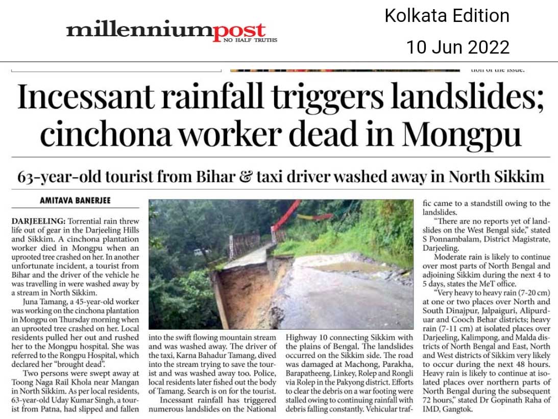
The deluge of Jun2022 (affecting Sikkim, Assam, Meghalaya (India), Bangladesh (Sylhet, Sumamganj) and Bhutan.
The north east of India and Bangladesh are no stranger to flooding - which is an annual event. This year the flooding started in May2022 but peaked in mid June2022 with rainfall records of more than a century being broken.
Meteorological conditions from 1Jun22 to 20Jun22
Meteorological conditions which led to the extraordinary rainfall in east India and Bangladesh were as follows:
a) An east west trough of low pressure existed for almost 3 weeks from western India thru Bihar, Sub-Himalayan West Bengal to Assam.
b) Westerly winds prevailed in much of mainland India as a result, both west and central India are, at the time of writing deficient in rain.
c) There was a persisting lack of weather activity in the Bay of Bengal with no lows or depressions forming for over a month.
d) Strong southerly wind flows to northeast India from the Bay pumped in extraordinary amounts of moisture into the region (see below).
Satellite Images of Clouding
Affected areas (India)
Indian states Assam, Meghalaya, Sikkim, and Tripura were severely affected by the excessive rainfall. The deluge started in May itself, when Assam got 62% above normal pre-monsoon rains (Zaman, 2022).
Some residents of Hojai district (Assam) alluded to faulty dam operations also being one of the causes of the deluge, “Even if there was a flood earlier, it used to take two to three days for the whole village to be submerged. This time, the entire village was submerged within 10-12 hours.” (Zaman, 2022)
Affected areas (Bangladesh)
Bordering the country of Assam, Bangladesh also faced the same wrath. It has been observed that in 122 years such flooding in the Sylhet region in Northern Bangladesh has not been observed. One of the fundamental reasons for the worsened condition of Bangladesh was the cascading water coming from the hills of Meghalaya. Assam and Meghalaya have received an excess of 125% rainfall as on 16Jun22. 'Heavy monsoon rains and water from upstream in India's northeast have inundated large parts of the Sylhet division, leaving millions of people marooned and triggering a humanitarian crisis. The flash floods swept away homes and inundated farmlands, forcing families to seek shelter on higher ground and temporary flood shelters, while power cut is making life miserable. Experts considered the flood worse than the ones they had experienced in 1998 and 2004. The crisis struck at a time when the people of the division were recovering from unexpected recent floods that hit in late May. An estimated 7.2 million people are affected
by this sudden flash flood and water congestion in nine northeastern districts of Sylhet, Sunamganj, Moulivazar, Habiganj, Kishorganj, and Netrakona, Brahman Baria, Mymensing and Sherpur. Among the nine districts, five heavily impacted are Sylhet, Sunamganj, Moulivazar, Habiganj and Netrakona. As many as 472,856 people have been taken to around 1,605 shelter centres in a combined effort of the Army, Navy,
Fire Service, and the local authorities, according to the Ministry of Disaster Management and Relief (MoDMR). Many households are isolated due to floods, while some have taken shelter in open areas. The safety and security of women and girls in those households are at high risk'- (Source: UN, Bangladesh)
Affected areas (Bhutan)
Information not available
Rainfall Activity from 15Jun2022 - 18Jun2022 Comparison between the monthly mean average for June with the observed rainfall activity has been shown below. The monthly mean average is calculated by using daily rainfall data from 1989 to 2018 and analyzed by IMD, Pune.
- In 4 days, regions in Assam and Meghalaya received their entire month's rainfall.
- Sikkim observed the same in 6 days.
Observed Rainfall
statistics:
Impact of the Deluge (India)
The extreme rainfall resulted in floods and landslides which severely impacted large swathes of the North East Region. Critical communication networks in terms of the Indian railways and National Highways (NH) were disrupted and Tripura faces acute shortage of essential commodities as parts of NH 6 (connecting Tripura, Mizoram, Manipur to the rest of the country) under Meghalaya's Lumshnong area have been affected by landslides.
Assam has reported landslides in Dima- Hasao, Goalpara, Morigaon, Kamrup and Kamrup(M) in the last few days. (Humanitarian Aid organization, 2022).
Meghalaya also reported landslides from three districts – East Khasi Hill (Mawsynram) ,South West Khasi Hills ,South Garo Hills and Llumshnong in Jaintia hills.
Some of the roads impacted in Sikkim due to many large and small-scale landslides are:
● 20th mile, NH10 between Singtam and Rangpo
● 17th mile Gangtok
● Singtam-Temi Tarku stretch
● Rangpo Rorathang stretch
● Jorethang-Namchi road
Latest report by the New York Times reports at least 116 fatalities due to flooding, lightning strikes and landslides in India and Bangladesh (NY Times, 2022). The Humanitarian Aid International reported that as of 22Jun22 there were 28 districts, 2,930 villages with over 19 lakh people affected and 54 fatalities in Assam.
Given below are statistics from the Assam State Disaster Management Authority from their Daily Flood Reports, from 16Jun22 - 19Jun22.
![]() |
Impact of the Deluge (Bangladesh)
The UN report is placed here
Impact of the Deluge (Bhutan)
Information not available
Images/Media reports
Ankit Mankar (Azim Premji University, Bangalore)
Shreya Gurung (SaveTheHills)
Praful Rao (SaveTheHills)