Showing posts with label rainfall. Show all posts

Saturday, December 10, 2022

Mapping rainfall in our region: NEW (DAVIS) AWS at Todey Village in Kalimpong station and location of Automatic Weather Stations (DAVIS) and Manual Rainfall Gauges.


STH has been monitoring rainfall in our region for many years now and we publish these records each month in this blog. 

The above map shows the location of 6 DAVIS AWS in our region which will give real time weather information 24 X 7 and also the location of 4 manual rainfall gauge stations.
Real time weather includes

  • Temperature (outdoor and indoor, max and min temp, graphical data)
  • Rain (current rain, 24hrs rain, monthly rain, yearly rain, intensity of rain in mm/hr)
  • Wind data ( 10min average, gusts and graphical data)
  • Barometric pressure (& graphical representation of variation)
  • Weather forecast.

How to get real time weather from the AWS
In order to get the real time weather from the 6 DAVIS AWS stations:

  • Download and install the 'WEATHERLINK Davis Instruments' app from Google play store.
  • You may have to register.
  • Search for Davis weather stations in Kalimpong, Gangtok and so on and save them.


    Praful Rao
    Kalimpong district
    Darjeeling -Sikkim Himalaya
    9475033744
    savethehills@gmail.com


Tuesday, August 2, 2022

Rainfall data of Jul2022 of some towns in the Darjeeling - Sikkim Himalaya

As per IMD, the southwesterly wind flow occurring over most parts of India and Indian Seas gives rise to southwest monsoon over India from June to September. The typical rainfall pattern over the Darjeeling-Sikkim Himalaya is shown below:

July is the month when our rainfall normally peaks, with the rains gradually decreasing thereafter.
The rainfall record of July2022 (day wise) of some towns of this region is  tabulated below:
You will notice that we have added rainfall data of
a. Mangzing (a remote village in Pokhriabong GP, Gorubathan block, Kalimpong district)
b. Bijanbari (Relling GP, Pulbazar block, Darjeeling district)
in our effort to map the rainfall of this region.
What is clearly evident is that the rainfall of July 2022 for many parts of the hilly regions of North Bengal and Sikkim was significantly below the normal monthly rainfall (615.8mm). Also for the first time in many years, Kalimpong rainfall exceeded that of Darjeeling.
What is also noticeable from the graph (Fig 1) is the towns mentioned had significantly higher rainfall in June than July which is an anomaly.
Fig1

July 2022 began with a large deficit in rainfall in the Sub Himalayan W Bengal and Sikkim regions however, the rains picked up a little in the third week of July. The paddy crop which is normally planted in July in rain flooded fields never happened in many places (Fig2).


 Fig 2
There was also very little activity in the Bay of Bengal and Pacific Ocean in this entire period  with hardly any typhoons forming in Pacific or low pressure areas in the Bay. A low which formed in Bay on 10July along with the rainfall deficiency is shown in Fig3:

 Fig3
Rainfall departures for July2022 for W Bengal and Sikkim are given below (Fig4)
Fig4
Rainfall was also deficient in South Bengal (Fig5)
 (Fig5)
Despite the deficit in rainfall, there were landslides especially along roads and NH10


Landslide at Reshi checkpost on NH717A (below Pedong (Kalimpong district) on 25July 2022.

Shreya Gurung
&
Praful Rao

Kalimpong district
Darjeeling Sikkim Himalaya

Sunday, February 20, 2022

SaveTheHills activitiy: In person workshop on 'Landslides and Environmental Issues of the Region) at DISHA Center, Kalimpong -18/19Feb2022

Raising awareness on the severe landslide problem of this region and other environmental issues of the Himalayas has always been one of STH's main roles and so we have carried out literally hundreds of awareness programs not only in this region but also in Delhi, Kolkata, Gauhati and so on (all documented in this blog).
The COVID pandemic put an abrupt stop to our in person meetings but we did carry on using various online platforms.
With the pandemic restrictions being eased, we have resumed our outreach programs and this was one such event.

We have featured the landslides in Sindebung in many earlier blog reports (see 1, 2) besides taking media people, scientists, students and govt officials to the site.
I visited the village after several years, because of COVID restrictions and I was astonished to see the huge numbers of large new buildings and homes which have come up in the area but the plight of the landslide affected people remain unchanged.
I felt a sense of guilt, anguish and helplessness when the villagers who's homes are on the edge of the landslide  again asked me to do 'something', lest all their assets and belongings disappear.

Praful Rao and the STH team
Kalimpong district
Darjeeling - Sikkim Himalaya

Sunday, February 6, 2022

Hyperactive WDs and unusual (heavy) snowfall in our region 04-05Feb2022

As forecast by IMD, we had bumper to bumper Western Disturbances sweeping in from the west from Jan till now. This along with moisture incursion from the Bay of Bengal and the Arabian sea resulted in rain, hail and snowfall in our region on 04-05Feb2022.


Praful Rao
SaveTheHills
Kalimpong district
Darjeeling-Sikkim Himalaya

Thursday, February 3, 2022

The weather of Dec 2021 and the closing ceremony of SMDS X (Kalimpong chapter)

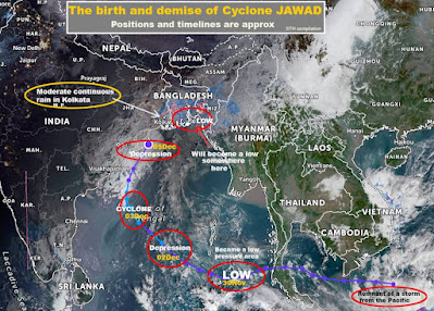
December began with a low pressure area in the Andaman sea which ultimately intensified into Cyclone 'JAWAD' - which curved towards Bangladesh and gave some rain over Kolkata on Sun05 Dec2021

Western disturbances were very active towards the latter part of Dec 2021 and affected our region a lot.


Hail storms in this region were reported at

1. Rishyap (Kalimpong district) - 22Dec
2. Shillong - 22Dec

Intermittent rain/drizzle was reported at

1. Kurseong
24/25/26Dec (21.6mm reported on 26Dec)
27Dec (2.2mm)                                            
29Dec (1mm)
3. Jaldhaka
25Dec (9mm)
4. Darjeeling
25Dec
29Dec (13.2mm)
5. Kalimpong
29Dec (5.3mm)
6. Jaldhaka
24Dec (9mm)
29Dec (2.6mm)
7. Gangtok (East Skm)
24Dec
28Dec (12.2mm)
29Dec (14.6mm)
8. Damthang (South Skm)
24Dec (3.2mm)
28Dec (13.4mm)
9. Dentam (West Skm)
25Dec (1mm)
28Dec (6.5mm)
29Dec (7.5mm)
10. Mangan (North Skm)
27Dec (4.2mm)
28Dec (19.2mm)
29Dec (19.2mm)

Snowfall reported at

1. Jalpahar (Darjeeling)
25Dec
2. Ghoom (Darjeeling)
29Dec
3. Dhotrey (Darjeeling)                

Drawing the curtains down on SMDS X at Kalimpong on 11 Dec2021 (International Mountain Day)


Ending 2021 with a piece of Good News


Praful Rao
SaveTheHills
Kalimpong district
Darjeeling Sikkim Himalaya

Monday, April 27, 2020

Rainfall data of some towns in Darjeeling-Sikkim Himalaya: Jan2020

Data of Sikkim is from IMD

Thanks Shreya for yr help :)

Praful Rao
Kalimpong district
Darjeeling-Sikkim Himalaya

Thursday, October 31, 2019

Closing Oct2019 with a bang : 3 Cyclones in the region

Oct 2019 for Kalimpong and Darjeeling districts has been dry. We are almost -60% in the monthly rainfall. Nevertheless, there has been plenty of weather activity elsewhere in the country with peninsular India and the western coast receiving plenty of rain.
As the curtains came down on Oct, we have 3 active storms in our region as shown above.

Update on 03Nov2019


Update on 05Nov2019
Caught in a pincer movement by two storms

Update on 10Nov2019
Praful Rao,
Kalimpong district
Darjeeling-Sikkim Himalaya

Saturday, February 9, 2019

Notice and Regrets

It is with regret that I wish to announce that we were unable to continue the SaveTheHills (STH) blog after April 2018, having done so for almost 10years since STH was established in Sep2007.
The reason:-
  • In our experience, STH has found that other social media platforms are today more efficient and 'user friendly' to disburse warnings and information.
  • While blogging may have once been a wonderful tool, today STH operates a WhatsApp (WA) group called 'Hazard Alerts' (HA) which is a much more effective way of disbursing information and warnings.
  • WA along with other platforms like FaceBook reaches out to wider audiences and very quickly while the blog maybe restricted to the more serious reader and for preserving data and historical facts.
    However, since all of STH history and some useful data is published in the blog, STH will again start re-publishing the blog while apologizing for the break.

    Firstly, we will publish the available rainfall and other records of this region and then significant events which were undertaken by us and our partners during the past in 2018.

    Praful Rao,
    Kalimpong district,
    Darjeeling - Sikkim Himalaya

Saturday, January 21, 2017

STH Activities (18/19Jan2017) : Participating in Project 'LANDSLIP' and an awareness program with Colby College (USA)

In the bottom slide (with Colby College) STH President is 1 and Prof Roy 2.

An excerpt from the Telegraph on Project 'Landslip' is reproduced below :-

"Darjeeling, Jan. 19:
An international science consortium has picked Darjeeling in north Bengal and the Nilgiris in south India to test a new mechanism for landslide risk reduction through better assessment, early warning systems, and improved community preparedness.
Scientists from India, Italy, and the UK plan to combine terrain geology with weather data to improve their understanding of landslide dynamics and use that information for risk assessment and alert local communities to potential hazard zones.
Tracts of the Darjeeling hills are highly vulnerable to landslides that have killed many people over the years. In July 2015, more than 40 people died or went missing in landslides across the hills. Some areas of eastern Sikkim will also be included in the project.
The scientists caution that their four-year project, funded by the UK's Natural Environment Research Council, the Department for International Development, through the Science for Humanitarian Emergencies and Resilience programme, does not seek to predict landslides.
"First and foremost, we are not predicting landslides. What we are doing is looking at and collecting information on landslide hazards," said Helen Reeves, the director of science for engineering geology with the British Geological Survey.
The Geological Survey of India, a major partner in the project, will provide the landslide data available for the area since 1899.
"One of the reasons for choosing this area is that data availability, landslide susceptibility, and varied terrain conditions," said Saibal Ghosh, the director of GSI. "Tea gardens here, too, have maintained rainfall data for decades and it will also be useful."
Bruce Malamud, professor of natural and environmental hazards at King's College, London, said: "The project will look at a combination of things such as elevation, geology, and landslide susceptibility. We are basically saying there could be an elevated chance here, and a reduced chance there."
The scientists plan to generate early warning systems to disseminate potential hazard information among local communities. The Italian National Research Council has already developed a forecasting system that regularly alerts local governments.
The India project will also seek to involve district administrations to reach out to communities, although the medium of communication is yet to be determined. "We will look for what best suits the local communities," said Malamud. "Maybe, we could work out a system that could use text messages, social (media), smartphones, radio, or other wireless systems."
Scientists from India's Amrita Vishwa Vidyapeetham University, the UK Met Office, Newcastle University, Consiglio Nazionale delle Ricerche, Italy, among other institutions are also collaborating on the project.
Praful Rao of Save the Hills, an NGO based in Kalimpong which is working on natural disasters, said: "The very fact that an international consortium is working on landslides in the region is a major development. This would lead to a better understanding and preparedness for risk reduction."
The project also plans to invite experts from Afghanistan to share experiences with regard to landslides."

Praful Rao,
Kalmpong,
Dist Darjeeling

Tuesday, May 24, 2016

Friday, February 12, 2016

Climate Change (Input 2) - Insights from a recent paper : 'Anthropogenic footprint of climate change in the June 2013 Northern India flood'


 Synopsis of the Report :-

1. During 13 –17 June 2013, heavy rainfall occurred in the northern Indian state of Uttarakhand and led to one of the worst floods and landslides in history, resulting in more than 5000 casualties and a huge loss of property. This event also affected other parts of India including Himachal Pradesh, Haryana, Delhi and Uttar Pradesh, as well as western Nepal and parts of Tibet.

2. In a study by scientists, meteorological and climatic conditions leading up to this rainfall event in 2013 and similar cases were analyzed for the period of 1979–2012.
  • Using complex meteorological models to study natural and anthropogenic influences as well as the role of the long-term climate trends on rainfall in the region it was found that:-  Northern India has experienced increasingly large rainfall in June since the late 1980s.
  •  The increase in rainfall appears to be associated with a tendency in the upper troposphere towards amplified short waves.
  •  The phasing of such amplified short waves is tied to increased loading of green-house gases and aerosols.
  •  In June2013, 60–90 % of the rainfall amount was attributed to post-1980 climate trends with another study revealing that though this rainfall was at least a century scale event, the probability for such an incident recurring has increased in the present climate compared to that of pre-industrial times.
3. The study also found that such heavy rainfall and widespread flood events have become increasingly frequent in northern South Asia :-
  •  In July2010, an extreme rainfall event in northern Pakistan resulted in floods that killed about 3000 and affected around 20 million people.
  • More recently (2–6 September 2014), some regions in India (Jammu and Kashmir) and Pakistan (Azad Kashmir, Gilgit-Baltistan and Punjab) suffered extreme floods caused by heavy rainfall which killed more than 500 people.
4. The study found that increased levels of greenhouse gases and aerosols in the post-1980 period have caused changes in the upper troposphere and that as a result of anthropogenic climate change, the circulation structure has been modified in such a way that it significantly aggravates rainstorm occurrences in northern South Asia, hence increasing the severity of floods.
5. Also, the occurrence of this June 2013 event during pre-monsoon season in northern South Asia, along with the circulation and precipitation trends in June, calls for the adaptation of risk management strategies in the face of increasingly frequent and strong rainstorms outside the core monsoon months (July–August). Adaptation measures such as developing strategies and policies for flood management in the face of climate-related extreme events are urged.
6. In addition, the amplified upper-level stationary waves and associated dynamics, as revealed in this study, will need to be represented accurately in the forecasting tools revealed in the post-1980 trends is attributed.

The full paper is available here
For animation of the cloud movements of the 'Uttarakhand Cloudburst' see here

" It appears that the increase in aerosols due to pollution, combined with changes in the jet stream due to increasing greenhouse gases, have made June events like the 2013 flood more likely to occur since 1988."
- Jeff Masters, Director of Meteorology, wunderground.com

Praful Rao,
Kalimpong,
Dist Darjeeling

Wednesday, July 1, 2015

01Jul2015 : 226mm of torrential rain over a 6 hr period in Darjeeling district

For a hellish 6 hr period Darjeeling district especially Kalimpong was pummeled by torrents of rain starting from approximately 2000hrs.
I watched the clouding as it formed over us and remained almost stationery much like the clouding over Uttarakhand in 2013. Kalimpong received almost half (226mm)the entire July month's average rainfall (548.7mm) in the 6hrs and it is confirmed that that there have been at least 6 deaths in Kalimpong, numerous landslides and all the road links from Kalimpong to Siliguri are now cut off by slides.
The worst part is we have at least 3 months of rainfall ahead.

Praful Rao,
Kalimpong,
Dist Darjeeling


Saturday, June 27, 2015

Landslide blocks National Highway (NH) 10 (Siliguri-Gangtok) causes massive traffic jams on NH55


With NH10 (formerly31A) blocked by the slide above, literally hundreds of vehicles mainly to Sikkim and Darjeeling scrambled up NH55 yesterday and today causing massive traffic snarls some almost lasting 6-9 hrs.
Read more here

Photo credit : Mr Kundan Yolmo (Telegraph)

Praful Rao,
Kalimpong,
Dist Darjeeling