Showing posts with label NHPC. Show all posts

Friday, October 4, 2024

Commemorating the 'Teesta Valley GLOF of 04Oct2023' with photos of the event and its aftermath.

A woman washes the money she recovered while scavenging for lost property in a flood affected area of Rangpo (Sikkim) on 06Oct2023 - photo credit Praveen

As I write, it is very early morning on 04Oct2024 and it was exactly at this time last year that I was up at my home in Kalimpong, trying to contact and verify with people, mainly in Sikkim, about whether a GLOF had actually taken place in the Teesta valley.
In the meantime my cellphone was receiving images and videos of the floods as the wall of water tore down the valley. Just verifying what was happening in order to report and record it accurately  kept me engaged the entire day and next, while my young friend and photographer Praveen Chhetri visited Teesta Bazar which the GLOF hit around 4am. He recorded the impact of the GLOF as it happened.
I did not know then that this process of recording the GLOF and its impact would keep us busy for an entire year but it has - and has required numerous visits to many parts of the Teesta valley including one trip made in Nov2023 to Chungthang where the 1200mw Sikkim Urja hydroelectric dam was destroyed by the GLOF.
What we have in this blog is perhaps the most comprehensive photographic record of what was the largest GLOF which took place in the Himalayas. Praveen and I certainly have hundreds of images, many videos and voice recordings of the interviews of affected people that we did during the course of the year.

    Interviewing an affected person who had lost everything to the GLOF - Rangpo (Sikkim), 06Oct2023.

This post, where I publish some photos is only to commemorate that momentous event which changed the lives of so many
Lest we forget...

Army personnel recovering buried vehicles at Bardang (Sikkim) on 06Oct2023. 22 army persons who were a part of a convoy were swept away by the GLOF here
Landslide affected areas of Naga, a village between Mangan(district headquarters, North Sikkim) and Chungthang in Nov2023 (telephoto image from opposite hill). The village was almost entirely evacuated during the monsoons of 2024.
A man crosses the Teesta river on a bamboo bridge at Toong, North Sikkim in Nov2023. The bridge connecting Chunthang to Mangan was torn down by the GLOF
GLOF affected areas between Chungthang and Lachen town where there was no impact of the Sikkim Urja dam burst. The scale of the devastation caused by the GLOF alone is apparent in the photo - photo courtesy Dathup, Lachen.
GLOF eroded parts of NH10 between Teesta bazar and Melli in Oct 2023. With the Teesta river running 4-5m above the pre-GLOF levels, the erosion of NH10 increased remarkably in 2024.
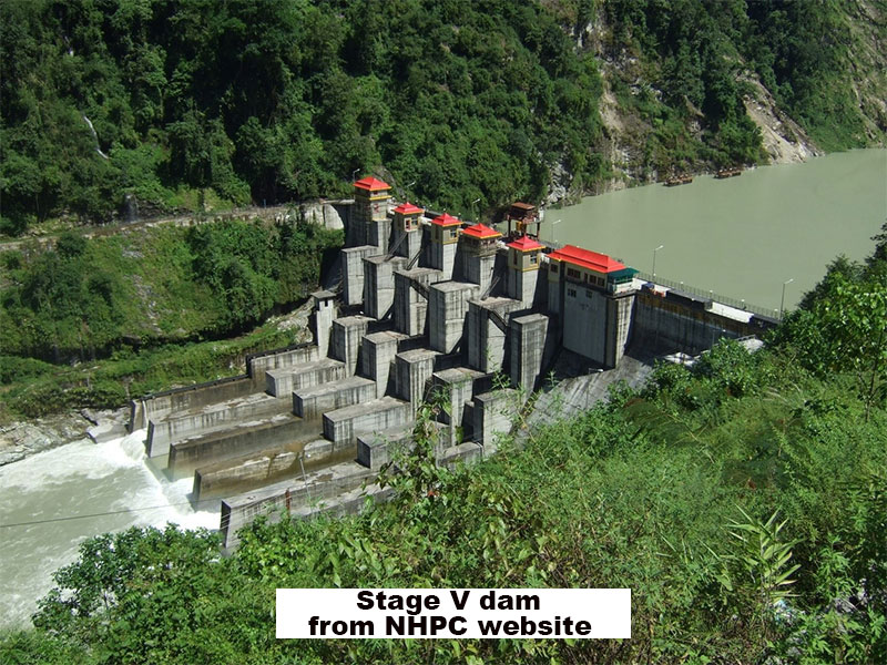
Debris and vegetation which the GLOF had dumped on top of the NHPC Stage V 510MW dam at Dikchu, SIkkim. The Teesta river 'over toppled ' ie went over the dam at this site.
Tree stumps and debris inside the NHPC Stage VI dam at Sirwani, Singtam (Sikkim), Nov2023
Vehicles strewn around like battered toys, on the banks of the Teesta at Singtam (Sikkim).
Part of Teesta town (Krishnagram or Bhasuwa) literally sliding slowly into the river - Sep2024
A marooned COVID hospital on the banks of the Teesta and Rangeet rivers at Tribeni, (Darjeeling district) - Sep2024. There is no road access to the hospital with the Teesta river having kept large parts of the access road submerged after the GLOF.
Rangpo town in Sept24. One year after the GLOF, parts of the town are still trying to recover. The river still flows uncomfortably close to the town and the police checkpost (green roofed structure on the top left is literally tilting into the river.
Undoubtedly one of the most iconic images of a GLOF.
Drone image taken by Praveen at around 11.00am on 04Oct2023 from the Teesta bridge when the GLOF was passing thru the area. As can be seen much of the Teesta bazar was already submerged.

Documentation of parts of the above report was supported by Royal Enfield, as part of their Social Mission Initiative


With
Praveen Chhetri (9733185815)

Praful Rao
SaveTheHills
9475033744
savethehills@gmail.com


Friday, December 1, 2023

Photographic record of the impact of 04Oct2023 GLOF on NHPC assets at SIngtam, Sikkim

BALUATAR, SINGTAM (27 15 1.8 N  88 27 34.1 E)

While returning from our visit to North Sikkim on 19Nov2023, we stopped by at Baluatar, Singtam to check the impact of the GLOF on the large NHPC complex there. It consists of the NHPC Stage V (Dikchu dam) power station, the Office of CEO, LANCO Teesta Hydro Electric Project, quarters for NHPC officers and personnel, a Kendriya Vidyalaya school, hospital and shopping complex .

View of the damage from NH10.
The damage to the assets has been huge with the bridge connecting the opposite bank at Baluatar washed away:
The whole area was deserted so we could not check when this area was hit by the GLOF, their experience or ascertain what was damaged except that which was immediately visible to us:
Damaged machinery outside the Stage V Power Station.


The raw power of nature is evident from these steel rods which have been bent and torn off. From photographs on the internet, there was a playground here and a lot of trees and greenery. The GLOF has swiped away everything and dumped almost 10 feet of sludge/sand  here.
Damaged electrical components of NHPC Stage VI dam complex at Baluatar
What appears to be a workshop covered with tons of sludge. A bus lies partially buried in the debris.
A structure excavated from approx 12 feet of sludge at the NHPC Stage VI complex.


NHPC TEESTA STAGE VI Hydro Electric Project Barrage at Sirwani, SINGTAM             (27 14 34.9 N  88 28 37.8 E)

The barrage, with what appears to be ruins of the bridge (see map) which was swept down by the GLOF

Literally every crevice and nook along the path of the GLOF has been filled up with millions of tree stumps. The destruction of forests by the GLOF should be quantified to know how much was lost to the floods.
This is the STAGE VI dam at Sirwani, SIngtam on 19Nov2023.

Praful Rao
Kalimpong district
Darjeeling - Sikkim Himalaya
savethehills@gmail.com
9475033744

with

Praveen Chhetri
Junkeri Studios,
Kalimpong
junkeristudio@gmail.com
9733185815


Tuesday, September 26, 2023

A strange coincidence: Landslide on NH10 at Sethi Jhora on 23Sep2020 and again on 23Sep2023 at exactly the same spot.

On 23Sep2020 a landslide occurred on the National Highway 10 (NH10) at Sethi Jhora, which was covered in the STH blog.

Of the 114km between Siliguri and Gangtok, 90km of the NH10 lies in the mountains and of this approximately 65km is along the banks of the Teesta where a number of dams have been constructed. Now IRCON is also building a tunnel for a railway which when finished approx next year end will link Sevoke with Rangpo in Sikkim.
NH10 is the lifeline for the state of Sikkim and Kalimpong and also a strategically important road and supply route for the Indian Army.

I have reproduced a press clip & photo from the STH blog dated 26Sep2020 below:

Exactly, 3 years later at the same spot (Coordinates 26.93946N 088.44148E, Elvn 233m) and again on 23Sep, an almost identical landslide occurred due to which National Highway10 from Siliguri to Gangtok is closed for traffic since 24Sep2023 (see image below) till date.

Rainfall in Kalimpong on 23Sep2023 was 58.4mm
Annual rainfall in the Teesta Valley is approx 2500-3000mm. The entire region is in Seismic Zone IV.
Why the failure occurred?
I think there are 2 factors at play. First, the Darjiling-Sikkim Himalaya is riddled with out-of-sequence faults that have been active recently. The Seti Jhora practically runs along the reactivated Ramgarh thrust fault core. Such fault cores consist of powdery crushed material that have very little strength.  The roads that run over such zones have much lower strength and load carrying capacity. If you saturate such zones with water chances are that they will liquify and cave in. September end would be a time where the monsoon has been around for a while and has saturated these zones particularly when a reservoir is also underneath it. Such a cave-in also happened in the Birrik fault core last year on the side of the road. No reservoir was involved there. Just the fault core material and rain.

- Prof Malay Mukul, Dept of Earth Sciences, IIT Mumbai

Images of Sethi Jhora (NH10) from STH's archives (2016)

Update on 27Sep2023
I was informed by a Govt Official that NH10 at Sethi Jhora was open for single lane traffic at 11.30am ie after 3 days of closure

Praful Rao
Kalimpong district
Darjeeling-Sikkim Himalaya
savethehills@gmail.com
9475033744

Friday, July 3, 2020

A pictoral record of the landslides of JUN 2020 in Darjeeling-Sikkim Himalaya


Shown above are the approx timelines when due to the more than normal rainfall in Jun2020, there were numerous landslides in the Darjeeling - Sikkim Himalayas and all occurred during periods of heavy rain. For example, in 6 days (17Jun-22Jun2020) Kalimpong received approx 78% of its monthly rainfall which is when all the landslides in Kalimpong took place.
More specifically:
a. Darjeeling and Kurseong area had landslides just as the SW monsoons entered the region on 12/13Jun 2020. Many of these landslides are documented here.
b. Kalimpong district which had almost no rain during this onset period, had intense rain on 17Jun which triggered a number of slides in the district.
c. Mangan (N Sikkim) and E Sikkim were the only places which had surplus rain over the winter months and continued to have very heavy rain towards June end and that triggered a number of landslides.
In order to maintain a record of the landslide events I am posting verified photos of some of them as submitted by HA members.

Kalimpong:
North Sikkim (Passingdang)
North Sikkim (District HQ: Mangan)27.4979° N, 88.5348° E

North Sikkim (Barfok)
27.509787°N, 88.437531°E
Debris Torrent as seen from across the Teesta from Mangan. No loss of lives, some houses evacuated.

Landslide at NHPC Stage V 510 MW Dam at Dikchu, East Sikkim


Landslip on Dhotrey- Maneybhanjang road (22Jun2020?)
Rimbick- Lodhoma landslide (28Jun2020)
at Chota Hatta, Kankeybong.

Breaches on NH55 (Siliguri to Darjeeling) near Pagla Jhora (Kurseong)
30Jun2020


My sincere thanks to all those who have volunteered their time and effort in 'HAZARDS ALERTS' (Whats App group)  and elsewhere to provide the information and photographs for the above record.

Praful Rao
Kalimpong district
Darjeeling Sikkim Himalaya


Sunday, June 30, 2013

Breach on embankment of River Teesta at 29th Mile (Kalimpong) : 30Jun2013


What is of concern is that we have had deficient precipitation in the whole of Jun2013 and rainfall normally peaks in July and August before starting to decline in September. Not surprisingly,  many of  the major landslide disasters ( see 1, 2 , 3 ) have taken place late in the monsoon season.

Praful Rao,
Kalimpong,
Dist Darjeeling