Showing posts with label Teesta. Show all posts

Wednesday, November 15, 2023

Photographic record of the impact of 04Oct2023 GLOF at Melli bazar and its vicinity -13Nov2023


Melli (27 05 24.2 N 88 27 29.6 E) Elev 232.9m, is a place which straddles the Teesta river. In South Sikkim, it is a small town, whereas in W Bengal (Kalimpong district) it is a transit place on NH10, Kalimpong district ,W Bengal.
We visited Melli during our survey of Teesta bazar on 10Oct2023 but could not access Melli (Sikkim) because the road from the bridge to the Melli town was closed to traffic.
On 13Nov2023, more than a month after the GLOF event I could make it to Melli town (Sikkim) with Prof Malay Mukul (Dept of Earth Sciences, IIT Bombay). Malay is from Kalimpong and was on a brief vacation here. These are some images from our visit on 10Oct2023:
Drone image (by Praveen) of the Melli ground  and stadium with the Teesta river nudging the edges of the complex.
Shredded parts of NH10 with a view of Melli town (Sikkim) from the opposite bank.
An excavator had started removing sand and sludge from the stadium on 10Oct2023.

Images from our visit on 13Nov2023 to Melli.
A dumper at the Melli ground belonging to SML company had been excavated along with the first floor of the several buildings at the rear.
The wreckage of another vehicle lay at the edge of the Melli stadium. Excavation of the sand, debris and sludge was continuing but seemed a humongous task considering the almost 10-15feet of sand that was dumped everywhere. Prof Malay Mukul can be seen in the background taking some readings.
Another view of the Melli stadium with buried vehicles strewn all over. Notice how close the river had come to the main town during the GLOF. In the distance and across the river is the IRCON railway tunnel.
This was the area which was most affected in Melli town (Sikkim) by the GLOF event.
A sombre Milan Gurung (48yrs) stands at his home near the Melli stadium with the Teesta river lapping up the edges of what used to be his front yard. He told us that 3 new vehicles from SML company were swept away here along with a large liquor storehouse.
He squarely blames the inundation of his home on the dumping of excavated tunnel material on the opposite bank by the IRCON project. He says the river first hit the huge IRCON debris on the opposite bank and rebounded from it, to flood his home and 10 houses around the stadium.
Milan Gurung told us the river was never so close to his home earlier and was fearful about living here now.
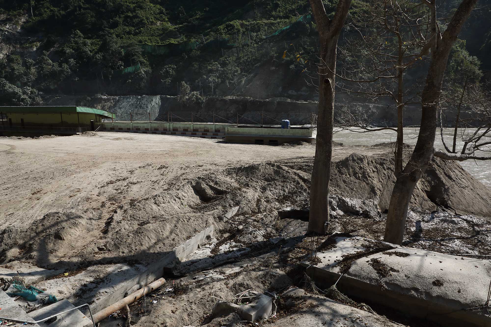
Debris at the opposite end of the stadium.
Residents of this area said the sewage treatment plant of Melli town was located here and it was either swept away or buried.
Dangerously poised GLOF affected buildings on the W Bengal side of Melli Bazar.
The problem is that there are so many weakened structures like these, everywhere with the river nibbling away at the base.

Images of Tribeni (at the junction of Rangeet and Teesta rivers)

Image of the GTA Covid Hospital at Tribeni on 10Oct2023.
Image of the GTA Covid Hospital at Tribeni on 13Nov2023.
Rangeet river water is distinctly green whereas that of the Teesta is still laden with silt and brown.
Road to GTA Covid Hospital at Tribeni on 13Nov2023
A large section of road (approx 300m) from Teesta bazar  to the GTA Covid Hospital at Tribeni is still submerged - with the river having regained its lost territory.
The river submerges the road here (27 04 6.8 N 88 25 39.7 E) just 10 mins walk from the Teesta bazar. Sadly, this place has now become a dumping ground for solid waste.

The road remains under water for a long time until it reaches here (27 04 14.4 N 88 25 49.2 E) where it climbs out of the river.

My thanks to Prof Malay Mukul for taking time off to visit these places. I will update his inputs in a separate blogpost.

Praful Rao
Kalimpong district
Darjeeling-Sikkim Himalaya
savethehills@gmail.com
9475033744


Thursday, October 19, 2023

Photographic record (18Oct2023) of Geil khola section of NH10 - post Lhonak Glacier GLOF.

One of the main casualties of the devastating Lhonak glacier GLOF on 04Oct2023 was the road communications and that too mainly the impact of the floods on NH10 which is the lifeline for the landlocked, mountain state of Sikkim and of Kalimpong district in W Bengal. Of the approx 114km distance from Siliguri to Gangtok, 65kms of NH10 winds itself along the banks of the Teesta.
More than two weeks after the GLOF of 04Oct2023 which shredded the highway at many places the road communications from Gangtok to Siliguri along NH10 has not been restored till date - neither the state highway which connects Darjeeling to Teesta Bazaar.

On 18Oct2023, I photographed the above section of NH10 from the sheer cliffs of Kalimpong district which overlook the highway from the opposite hill - with the intention of preserving the images of what was an extraordinary event for us living in this region.
The above image of Oct 2021 shows a very active landslide (A) at 29th Mile on NH10 (27 01.013N 088 26.087E) and Bangay bazar (B) on the banks of the Teesta.
Telephoto Image of NHPC's TLDPIII and parts of Bangay bazar on 18Oct2023, submerged by the GLOF. Dam operations on TLDPIII has been stopped by the local political party (GTA) for the time being. Do notice the width of the Teesta river and the color of its water which indicates it is still loaded with silt.
                                       A very active 29the Mile landslide zone in 2021.
This year the 29th Mile landslide remained stable even during the GLOF period.
Close up view of the same area on 18Oct2023. The huge mounds of sand on the right bank indicate river levels during the GLOF. NH10 also appears to have been eroded at places.
Likhu Bhir (27 02.181N 088 25.661E) was the most serious landslide on this route decades ago (see image below). After being relatively stable for years, it was reactivated by the GLOF. One can see trucks carrying construction material plying over the slide.
Geil khola (27.028965N 088.427644E) was one of the places which was hit by the GLOF of 04Oct2023. Notice the partly buried homes on the river bank. The District Administration has set up a relief camp at Geil Khola.
Geil khola and its surroundings on 18Oct2023.
Geil Khola - Likhu bhir section of NH10 on 18Oct2023.
It seems ironic that the Kalimpong element of Darjeeling Himalaya Railways (DHR) which used to operate the narrow gauge train from Siliguri to Geil Khola, discontinued its Kalimpong operations after the 1950 disaster in our region.
Damage to DHR tracks in Darjeeling by the June 1950 disaster (photo kind courtesy Das Studio, Darjeeling)
File photo of the Geil Khola - Teesta Bazaar section of NH10 in May 2017.
The same section of the road after the GLOF - notice the level and size of the Teesta river and the many places eroded on NH10.
This place is in the vicinity of the Teesta bridge. The erosion of the road along the banks of the Teesta can be seen here.
Will the NHPC TLDP III dam operations under circumstances where the level of the river has now risen significantly affect NH10?
Also the safety of the thousands of vehicles which will ply on the highway when it is reopens and especially during the monsoons of 2024 are questions which need to be pondered upon.

Praful Rao
Kalimpong district
Darjeeling Sikkim Himalaya
savethehills@gmail.com
9475033744

Saturday, September 26, 2020

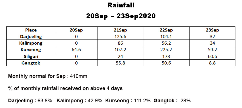
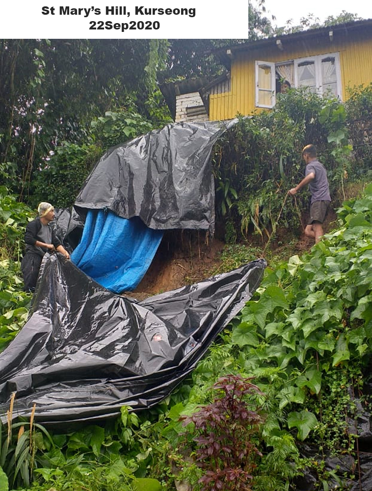
The Landslides of September end (20-23Sep) 2020

The above rainfall followed the formation of a LOW pressure area in Bay of Bengal around the 20Sep

21Sep2020 images

In the morning, we had a report in 'Hazard Alerts' our WA gp of extremely heavy rainfall on NH 10 and very soon this image of the flooded bridge (Coordinates 26.9832971E 088.417920N) at RAMBI (Kalimpong) was also posted.👇
Rambi was a small, sleepy town known mostly for the local mushroom production till recently- the construction of a dam (TLDP III) and the IRCON Sevoke-Rangpo Broad Gauge railway tunnel work have added prominence to the place.

Almost simultaneously reports of Mirik (Darjeeling district) experiencing torrential downpours came in and this image showing an ☝ area of Mirik town (coordinates 26.8853° N, 88.1828° E) near the lake was posted. It resembles a flooded place in the plains.

22Sep2020 images


Damage on National Highway (NH)10

SETI Jhora landslide
(Coordinates 26.93946N 088.44148E, Elvn 233m)

This ☝ gaping hole on NH10 was due to toe erosion by the Teesta river on 23Sep2020 at Seti Jhora . This spot has always been a major maintenance challenge on NH10 and has been responsible for several fatalities in the recent past.
Sign diverting highway traffic put up at Teesta after landslides blocked the NH10 at 29th mile 👇 on 22Sep2020.

29Mile Landslide (Coordinates 27.01435N 088.43594E, Elvn275m)


The scene was in fact worse in the plains of North Bengal 👇 as can be seen in the image from Cooch Behar (26.323921N89.451088E)

My thanks to all those who contributed the photos, reports etc via WhatsApp and in our group (Hazard Alerts) for us to maintain a record of the event for posterity,

Praful Rao
Kalimpong district
Darjeeling-Sikkim Himalaya