We have had incessant rain in our region for the past 24hrs or so and as always STH has tracked the cloud movements and put updates in our WhatsApp group 'HAZARD ALERTS 1 & 2' with a view to provide some rudimentary early warning to the community.
Perhaps it is this incessant rainfall, due to a circulation over Jharkhand, which triggered the GLOF in South Lhonak glacier in North Sikkim. A very technical study has been done and is available
here
The abstract from the article is reproduced below:
The Teesta basin in Sikkim Himalaya hosts numerous glacial lakes
in the high altitude glacierized region, including one of the largest
and the fastest-growing South Lhonak Lake. While these lakes are mainly
located in remote and unsettled mountain valleys, far-reaching glacial
lake outburst floods (GLOFs) may claim lives and damage assets up to
tens of kilometers downstream. Therefore, evaluating GLOF hazard
associated with current and potential future glacier-retreat-driven
changes is of high importance. In this work, we assess the future GLOF
hazard of the South Lhonak Lake by integrating glacier and hydrodynamic
modeling to calculate the lake's future volume and hydraulic GLOF
characteristics and impacts along the valley. We identify the increased
susceptibility of the lake to potential avalanche impacts as the lake
grows in the future. Here we model six avalanche scenarios of varying
magnitudes to evaluate the impact-wave generated in the lake and
overtopping flow at the dam. Avalanche simulations indicate that the
frontal moraine is susceptible to overtopping. The overtopping flow
hydraulics is evaluated along the channel assuming no erosion of the
moraine. Further, we consider three lake-breach scenarios to model GLOFs
originating from the lake, flow propagation, and its downstream
impacts. The uncertainty in the breach parameters including breach width
and time of failure are calculated to estimate the upper and the lower
hydraulic limits of potential future GLOF events. Further, the
uncertainty in the flow hydraulics was evaluated using dynamic flood
routing of six GLOFs that originate from the lake. Hydrodynamic GLOF
modeling resulted in a predicted peak discharge of 4311 m3s−1, 8000 m3s−1, and 12,487 m3s−1
for breach depths of 20 m, 30 m, and 40 m respectively. The
large-potential scenario suggests that maximum flow depth and flow
velocity at Chungthang, a town proximally located to a major hydropower station built-in 2015, could reach up to 25–30 m and 6–9 m s−1,
respectively. Mapping infrastructure exposed to GLOFs in the Teesta
valley shows that many settlements and assets located along the river
channel at Chungthang are potentially exposed to future GLOFs,
indicating the need to conduct a full environmental impact assessment and potentially undertake GLOF risk mitigation measures.


I was up at 2.20am after being notified of the GLOF by a friend. I spoke to several people in Sikkim to verify the information but it was difficult to get thru and rather embarrassing to disturb a person at that time.
After becoming reasonably sure of the event, I alerted the NDMA control room at 3.33am with a request to verify the information from SSDMA. (Sikkim State Disaster Management Authority).
I was surprised at the speed at which the flood waters advanced. Luckily, most people in the low lying areas made it to higher ground, despite the non-stop rainfall and darkness. Approximate timeline of the flooding (based on information given to me this morning by a friend when the event was unfolding) is given below:
Casualties and damage:
Sikkim State Disaster Management Report
Gangtok, October 4 (IPR): The Glacial Lake Outburst Flood
(GLOF) in portions of Lhonak Lake, Mangan District, which caused the rise of
water levels with very high velocities downstream along the Teesta River Basin
in the early hours of October 4, 2023, has caused severe damage in Mangan,
Gangtok, Pakyong, and Namchi Districts.
The lake outburst in portions of Lhonak Lake in North Sikkim caused a rise in
water levels with very high velocities near about 15m/sec, crossed the CWC
Melli site measuring 227 m, near about 3m above Danger Level, at 0600 am.
According to the Central Water Commission (CWC), the flood occurred at midnight
on October 3, 2023. Simultaneous flood forecasts for both India and Bangladesh
were made at 0600 hrs and 1400 hrs. The river Teesta is flowing below the
warning level at CWC Domohani FF Station. The water level at 0600 hrs is 84.83m
and is expected to cross its warning level within 6 hours.
Similarly, around 1 a.m. on October 4, 2023, the major flooding of the Teesta
River was reported from Chunthang. Likewise, by 2:30 pm, the flood had reached
the lowlying areas of the remaining districts, causing serious destruction to
public properties and public infrastructure. The communication network under
Mangan District surrounding Chungthang and its pheriphery has been affected.
Districts sprung into action and immediately initiated the evacuation of the
people from the lowlying areas.
Further, the SDRF team from the State Home Guard and Civil Defence, Gangtok,
and NDRF Pakyong has already been deployed in the affected areas.
As per the report received from the
SSDMA, the following damages have been reported from the districts:
(i) Mangan District: Chungthang cut off due to the Toong Bridge collapse.
Phidang Bridge collapsed. Four pucca houses at Phidang were washed away. Two
houses at Dikchu were washed away. Houses along the river line are in danger,
and two GREF labourers are reported missing at Sangkhalang, as per information
received from GREF sources and one person missing from Phidang.
The GREF Crusher Plant and Old Police Barrack have been washed away at Toong,
and four people have been reported missing.
Forest Guest House and two units of government quarters at Sangkhalang has been
swept away.
(ii) Gangtok: Four injured have been taken to Singtam Hospital. 25 people have
been rescued by SDRF, more rescue is underway.
(iii) Namchi district: LD Kazi Bridge washed away. Indreni Bridge washed away.
A relief camp was set up at Namphing Sai Mandir. As of now, 500 people have
been kept in the relief camps, and permanent relief has been set up at Pranami Mandir.
(iv) Pakyong district: Two minor injuries, one dead in West Bengal, and one
person is under observation at Rangpo PHC. 23 army personnel have been missing
and one person has been rescued at Bardang.
SSDMA
Fatalities/Missing
Known missing thus far are 23 army soldiers who were presumably swept away from their barracks at Bardang near Singtam by massive 15-20' waves of the Teesta river.
20 civilians are also reported missing.
Damages
Proper estimation of the damages in Sikkim and W Bengal may take some time. However, the major damage are as follows:
1. Sikkim Urja Dam at Chungtang, a 1200 MW Teesta Stage III Hydro Power plant was partly swept away by the GLOF resulting is huge release of water.
2. Indreni bridge at Singtam (30km from Gangtok) and another bridge at Baluatar were swept away. Several other bridges have also been washed away.
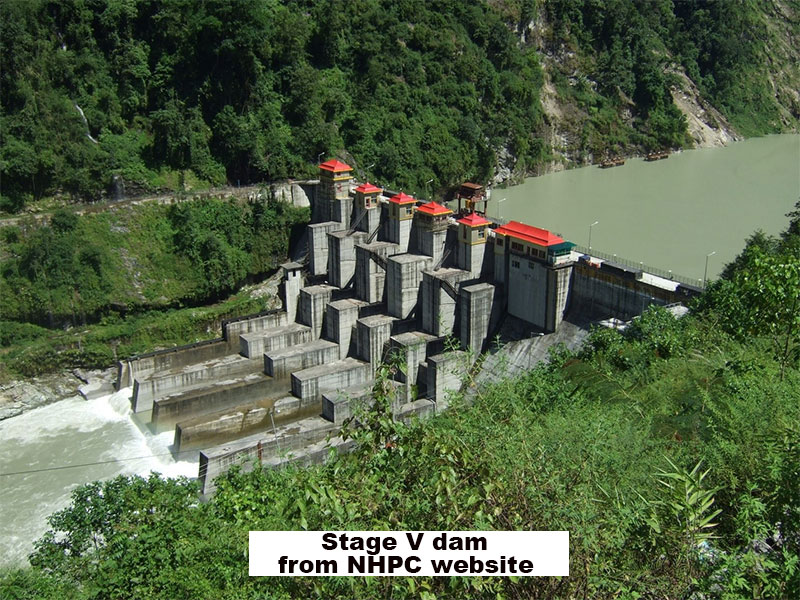
3. Control room of NHPC Stage V Dam at Dikchu has been damaged.
4. NH10 and communication lines all over Sikkim and Kalimpong district in W Bengal have been severely damaged at many places. Road towards Darjeeling from Kalimpong is severely damaged at Teesta bazar.
5. Three districts in Sikkim including Mangan (north Sikkim), Pakyong and
Gangtok (east Sikkim) were severely affected. Mangan was the
worst hit.
Will update this continuously over the next few days as more information is available
Incredible photos (includes drone imagery) by STH photo/videographer Praveen Chhetri of the GLOF devastation at Teesta bazaar (taken in the morning on 04Oct2023)
Why at Teesta Bazaar only and not in Sikkim?
Because there is no road access anywhere - National Highway10 (NH10) towards Siliguri is damaged and eroded, as is the highway to Gangtok. The road to Darjeeling from Teesta has been 'eaten away' by the floods this morning


 Fidang


 All drone images by Praveen Chhetri, Junkeri Studios, 9733185815