Sunday, May 10, 2015

Nepal 7.9R Earthquake (25Apr2015) : 96 Aftershocks (in two weeks) and still counting...

Placed above is a record of aftershocks (source) following the 7.9R earthquake which devastated large parts of Nepal on 25Apr2015. There have been 96 aftershocks till date (including the induced 5.1R quake which was epicentred around Mirik.
In order to generate awareness about quakes especially amongst the people of the Himalayas, I posed several questions to experts.
The questions and answers (in this case given by Dr Malay Mukul, of IIT Mumbai, Dept of Earth Sciences) are placed below :-
Q. Regarding the Nepal quake, why are there so many aftershocks WITHIN a short time frame - 96 within a time span of 2 weeks? The 6.8R (18Sep2011) Sikkim earthquake which we experienced never generated so many aftershocks.
A. This is normal. If you just see the aftershock records for the Bhuj earthquake,you will find that they continued for months after the main shock. You would see is a gradual decrease in the aftershock magnitude as well as number of events. Now we are mostly getting 3s and 4s.
The aftershock activity is also a function of the magnitude and depth of the main earthquake. Shallower and large magnitude main shocks create more intense aftershock activity.
The Sikkim earthquake was much lower in magnitude as well as deeper.
Q. Are the continuous rattling (aftershocks) dangerous for installations and structures already weakened by previous tremors? I know that 2 hydel projects in Darjeeling district suffered some damage during the recent quake.
A. Yes! Aftershocks tend to add to the damage created by the main shock and in many cases topple structures that were still standing at the end of the main shock. So if your building has suffered structural damage you need to make sure you either fix it or stay away from it.

______________________________________________________________

Comment by Praful Rao
My thanks to Dr Malay Mukul for his prompt answers. 

Two major earthquakes have shaken in this region within the last 4 years, (6.8RSikkim and the recent Nepal one), yet we continue to flout all regulations regarding building codes and continue to construct thousands of 8-9storey buildings on these fragile mountains. I also wonder whether the numerous dams that we have constructed or are constructing  are safe?


Praful Rao,
Kalimpong,

Dist Darjeeling

Thursday, May 7, 2015

Earthquake induced landslides and the onset of the SW monsoons 2015

Placed above is a preliminary map of Earthquake Induced Landslides in Nepal (read Dr Dave Petley's report here). I am aware of a similar study being carried out by a team from the GSI in the Darjeeling-Sikkim region.
With the SW monsoons knocking at our doorsteps and almost 3000mm of rain ahead (for Darjeeling district) in the next 5months, my biggest fear is how our injured mountains will bear up with this onslaught... and don't forget that 'developmental activities' such as road building and construction work including those of dams have gone ahead over the years, at breakneck speed in this entire region, with little regard to the environment.
In this regard, placed below is an article by Ranit Chatterjee, a graduate of TISS and now a student at Kyoto University(Japan):-


A STITCH IN TIME SAVES NINE

In the back drop of the recent earthquake in Nepal followed by temblor in the hills with epicentre located in Mirik and keeping in mind the approaching monsoon season ,the area may get hit badly by landslide in the coming months. The occurrence of earthquakes in steep landslide-prone areas greatly increases the likelihood that landslides will occur, either because of ground shaking or shaking-caused dilation of soil materials, which allows rapid infiltration of water. The second condition is more serious for Darjeeling considering the soil and rock conditions. The Darjeeling area may see an increase in landslides as an after effect of the series of recent earthquakes and onset of rainy season. Interestingly, it has been noticed that the rainfall pattern has changed in the region. The annual rainfall though has not changed much but the rainfall pattern is no longer uniformly spread over five months but happen in concentrated pockets over a short span of time mainly in July and August. This increases the runoff and chances of landslides increases.
In order to increase the level of awareness and preparedness at both institutional and personal level following measures can reduce the risk to a certain extent.  
1. Early warning system especially for heavy rainfall, landslide is an effective measure for saving lives. In the hills due to very spread out settlements it is important to set up a mechanism to transmit message across to villages. The banging of electric poles  can be used effectively to alert people when power supply is down and SMS is not available.
2. Identify safe locations for each area and the knowledge of safe location should be communicated to the community. A general system needs to be practiced where community leaders can guide them to the safe house. Like practiced in Japan once a year a real time mock drill for evacuation may be useful to put down a protocol and understand the evacuation process.
3. In case of houses, which have been damaged in the recent earthquake or aftershocks. It is recommended to get a structural safety check done by a qualified structural engineer or Civil engineer. Architects are trained in design and basics of structures and can handle up to 4 storied buildings unless he or she has a specialization in structures. Draftsman and masons are equivalent to quacks please avoid their advise on design and structural safety.
5.  Check for possible signs of landslides like tilting of trees, fences, and electric poles. Cracks in the lintel and sill of doors and windows.
6. Observe the weather closely everyday on your smart phone or Internet. A good practice is to keep a check on the weather forecast and warnings for the day.
7. Know the emergency contact numbers of the local fire service, police, disaster management department, ambulance etc.
8. Keep important documents inside plastic packet to protect from damage by water. Laminating important document is another of protecting the documents.
9. Preparation of an emergency kit at household level.
______________________________________________________

Praful Rao,
Kalimpong,
Dist Darjeeling

Thursday, April 30, 2015

From the Telegraph (India) today : Non-functioning Indian Seismic Sensors during the Nepal Quake

Indian sensors slept through quake- Assessment hampered

 New Delhi, April 29: A network of 293 ground motion sensors located across northern, eastern and northeastern India lay crippled during Nepal's 7.9 magnitude earthquake and its aftershocks, handicapping researchers trying to assess how the quakes affected cities and towns in these regions.
No one knows how many of the 293 sensors designed to measure ground acceleration during earthquakes were actually recording data during the weekend earthquakes because funding for maintenance of the instruments was stopped in September 2014.
The Indian Institute of Technology, Roorkee, had established the network between 2005 and 2008, installing the sensors in district headquarters across northern and eastern states, including Bengal and Bihar, under a project funded by the Union science and technology ministry.

But the earth sciences ministry stopped funding the project in September last year, and informed IIT Roorkee in February this year to prepare to hand over the sensors to the National Centre for Seismology (NCS), an institution under the ministry.
Read full story here
______________________________________________________


Comment by Praful Rao

Automatic sensors and instruments perform an all important task of recording scientific data without human intervention even under the most adverse circumstances and are especially valuable for measuring data in remote mountainous regions.
Some years ago IMD did the laudable task of installing numerous AWS (Automatic Weather Stations) and ARGs (Automatic Weather Stations) covering almost the entire country and even neighboring countries like Bhutan, the data from which is available, free of cost here.
Unfortunately, like the seismic sensors which were dead, resulting in loss of valuable data when  the Nepal quake occurred, many of the AWS/ARG stations have not been working or give erroneous meteorological data - some for many years now.
I have personally brought this information to the notice of concerned government officials at the highest levels by email and otherwise - only to receive a stoney silence as the reply.
Some of the AWS/ARG stations which are dead (and this list is far from complete)  as on date are given below:-


Automatic Weather Stations (State and locations)
Uttharkhand: Purola, Pant Nagar Agro, Rudraprayag, Nainital, Joshimath, Mussoorie
Sikkim: Mangan
WBengal: Darjeeling, Hashimara
Nagaland: Dimapur, Zunheboto
Himachal Pradesh: Una, Palampur
Arunachal Pradesh: Upper Subansiri, Papumpare

Automatic Rain Gauges  (State and Locations)
WBengal: Kharibari, Chengmari
Sikkim: Namtham, Yukson
Uttarkhand: Ranikhet, Someshwar, Bageshwar, Kalsi, Kasya, Ukhimath, Jakholi
Nagaland: Satakha, Phek
Himachal Pradesh: Dharampur, Baijnath
Arunachal Pradesh: Dirang
Mizoram: Vairengte

Praful Rao,
Kalimpong,
Dist Darjeeling

Wednesday, April 29, 2015

Hope amidst Hopelessness and an Expert's view


In a bid to throw light on the probable cause, duration and impact of the 25th April 2015 Nepal earthquake, STH has been contacting several renowned experts in seismology and disaster management. Thus the grim foreboding for the Darjeeling-Sikkim region from Prof. Malay Mukul of IIT, Mumbai (Dept. of earth sciences) is placed here.

A clarification/assessment of the frequent aftershocks following the 7.9 R earthquake by Prof. Dave Petley (Pro-VCO), University of East Anglia, UK, is placed here.

Prof. Rajendra Bhandari is acknowledged as one of the leading experts in the world on landslides. An excerpt of his letter to STH regarding the Nepal earthquake is published below:-

"The Nepal earthquake should not have surprised us because a number of studies expected a repeat of 1934 Bihar-Nepal earthquake. Similarly, India should not be surprised if the 1897 Shillong earthquake repeats anytime. Unfortunate we begin to speak of earthquakes and landslides only after the events and do nothing between the events. Then we fool ourselves by throwing up the argument that earthquakes are to be accepted because we cannot predict them. Why can we not fix all the major landslides in Shillong, Darjeeling and other parts of NE by spending 1000 crores before the Shillong earthquake arrives? 

Perhaps this 1000 crore is reserved for the families of those who would die in the quake. Why do we not retrofit all our hospitals so that victims will not have to wait for the Pakistani plane to arrive! Why do we not train communities, make earthquake-proof shelters and improve communication systems. We need a strong will to do something before our own day of departure comes. 

The aftershocks post Gujarat earthquake were also as alarming. My gut feeling is that the major event for the time being is over even though some aftershocks may keep repeating. The magnitude of aftershocks would also diminish within a few days. Had this earthquake been of magnitude 5.5-6 to begin with, perhaps those would have been fore shocks, appearing as the advance team of the main event to follow."

Praful Rao
Kalimpong,
Dist Darjeeling

Photo credits: CNN


Tuesday, April 28, 2015

The Kathmandu Quake: A planning and preparedness study published 15 years ago and a view from an expert.

15 years ago a study titled ‘Kathmandu Earthquake Scenario’ was published by the National Society for Earthquake Technology (NSET- Nepal) and GeoHazards International (GHI) which dealt about a possible major earthquake disaster in  the region. The publication can be downloaded here.

Kathmandu Earthquake Scenario,
A product of the Kathmandu Valley Earthquake Risk
Management Project 
implemented by National Society for 
Earthquake Technology-Nepal (NSET-Nepal)
 and GeoHazards International (GHI)

What I am sure of is that the publication  was never read and lay collecting dust, like so many GSI reports on landslide hazards do in India. It is a pity what General William Westmoreland said way back in the 1960’s, of life being ‘cheap in the orient’ holds true to this day.

Prof. Dave Petley (Pro-VCO), University of East Anglia, UK, is one of the world's foremost experts on landslides and geo-hazards. His blog, has featured STH several times. 
His reply to our query regarding the numerous aftershocks in Nepal and the 27Apr2015 (5.1 R) quake near Mirik, Darjeeling district, is reproduced below:-

Dear Praful,

Many thanks for your email.  The earthquake in Nepal has been a terrible disaster. 

We have known for years that this area was overdue a large earthquake.  The mechanism and effects are not unexpected, and so far there is nothing terribly surprising.  In the aftermath of a large earthquake we would expect to see two types of earthquake events – aftershocks within the zone affected by the main shock, and induced earthquakes more widely.  We would expect these events to be substantially smaller than the main shock, but they can be quite large in their own right.

So what we are seeing is exactly what we’d expect to see.  There is no reason to panic – there is nothing to suggest a larger event is imminent, despite the rumours.  The aftershock sequence will settle down over time.  We would expect the largest aftershock for an M=7.8 earthquake to be M=6.8, so everything is as expected.

Hope that helps.  Best wishes,
Dave


Praful Rao
Kalimpong,
Dist Darjeeling

Update (28Apr2015) : List of Aftershocks and other Quakes in our region

Red dot shows induced earthquake at Mirik (Darjeeling dist, W Bengal)

Source of top data sheet : IMetD

Praful Rao,
Kalimpong,
Dist Darjeeling

Monday, April 27, 2015

Images from Ground Zero and a stark warning from another scientist : A letter from Prof Malay Mukul (IIT, Mumbai)


Prof Malay Mukul, of  the Dept of Earth Sciences, IIT Mumbai is from Kalimpong and has done extensive studies on the seismology of the Darjeeling-Sikkim Himalaya. 

He has contributed numerous articles to this blog, besides taking part in several seminars we had  organized. I had written to him after asking his inputs after the recent Nepal quake and I reproduce his reply in toto, in the hope that we living in this beautiful, yet fragile mountains may treat our home with more respect :-

First of all the earthquake was pretty much expected. (see here)

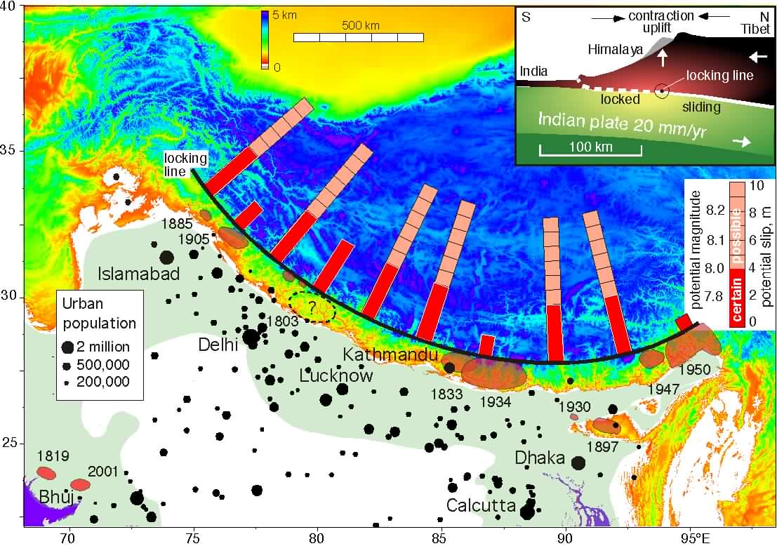
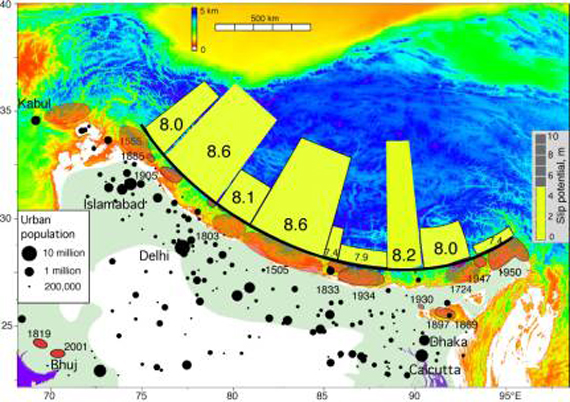
It was an earthquake that originated on the Main Himalayan Fault which is the basal thrust fault of the Himalaya and is also known as the Himalayan Decollement. Himalaya hosts many earthquakes; but the ones that involve the decollement are the great earthquakes whose magnitude is >8.0. These are the ones that all of us dread. The April 25, 7.9 Nepal Earthquake was a decollement earthquake and was bang in the middle of the high risk zone (Please see the two pictures given in the thread above, originally prepared by Roger Bilham, the longer the bar the higher is the seismic hazard in the region). The previous earthquake in the region was in 1934 and was a 8.1 earthquake which killed 10000 people. The expected projection for a repeat of that earthquake today was 49000. So who knows what will be the eventual death toll in this one.

What is also important and is evident from the two figures in the thread above is that there are other areas in the Himalayas that are waiting to be hit. Darjeeling-Sikkim is one of them. The 2011 earthquake was a strike slip one which is not the type we see in Nepal. We actually still await a Nepal kind of earthquake. With the concrete jungle that has mushroomed in our part of the Himalaya, Gangtok is likely to be our Kathmandu!

Aftershocks will continue for sometime. We have already had 45. There usually are a few aftershocks that are about 1 magnitude less that the main shock. We have already had a 6.7 and a 6.6 but most of the activity has been between 4-5. Aftershocks greater than 6.9 are not expected for this earthquake.

A final note: Although we can predict earthquakes in space, we are hopelessly off in earthquake prediction in time. So please do not believe any rumours that give you time predictions on earthquakes.

If you have questions, please let me know.

Best regards, Malay

Photo credits: CNN.


Praful Rao,
Kalimpong,
Dist Darjeeling

About prediction of earthquakes.


Several years ago soon after the 18Sep2011 (6.9R) Sikkim earthquake, I received a rather unusual request from an organization in Siliguri - they wanted me to come there from Kalimpong to assure a section of the public on TV that another big quake would not take place in the near future. Because many people, undoubtedly suffering from some form of PTSD were unable to sleep especially in high rise apartments. Needless to say I declined the offer.
A similar situation is again persisting today, in much of North Bengal and many parts of Bihar. In Darjeeling district schools are closed for the next 2 days in anticipation or more correctly fanned by rumors that major aftershocks are expected within the next 48hrs. I have also been dogged by local media asking whether this is possible.
Having been involved as a lay person in Disaster Management, all I can say is, unlike many other disaster forms (landslides, droughts, floods, cyclones, and so on), earthquakes are notoriously unpredictable and this has been substantiated by two senior scientist friends of mine who have spent almost their entire lives studying geo-hazards.
Placed below is an extract from 'Fundamentals of Geology' by Vladimir Obruchev about the predictability of earthquakes :-


An earthquake prediction implies that an earthquake in a specific magnitude range will occur in a specific region and time window. Predictions are considered as such to the extent that they are reliable for practical, as well as scientific, purposes. Although there is evidence that at least some earthquakes in some tectonic regimes are predictable with useful accuracy of time and space, the reliability and reproducibility of prediction techniques have not been established beyond the level of conjecture. We are still far away from predicting an earthquake with any amount of accuracy. Besides, any attempt to predict an earthquake precisely means deciding well in advance when and where it will occur. It will also be necessary to suggest about the magnitude of the shock and what could be the likely damage. An element of conjecture is always associated with any prediction.
It may be easier to predict where a major earthquake is likely to hit rather than the time when it will occur. Most seismologists do not believe that a system to provide timely warnings for individual earthquakes has yet been developed, and many believe that such a system would be unlikely to give significant warning of impending seismic events. More general forecasts, however, are routinely used to establish seismic hazard. Such forecasts estimate the probability of an earthquake of a particular size affecting a particular location within a particular time span.
In an effort to predict earthquakes, people have tried to associate an impending earthquake with such varied phenomenon as seismicity patterns, electromagnetic fields, weather conditions and unusual clouds, radon or hydrogen gas content of soil or ground water, water level in wells, animal behaviour. Thus far, earthquake prediction is controversial because data are sparse and there is little evidence or verified physical theory to link observable phenomena to subsequent seismicity. The frequent practice of polishing predictions after the fact further complicates the matter. Most assessments rely on chance models for earthquake occurrence, models that are difficult to test or validate, because large earthquakes are so rare, and because earthquake activity is naturally clustered in space and time. The best advice that has been provided by many seismologists is to consider the earthquakes as natural phenomena, and the people living in zones of high seismicity should learn to live with these unfriendly events, as we do in case of a violent storms and cyclones.
_____________________________________________________________

My thanks to
Prof Ananda Chakrabarti (retd),
Associate Professor,
Presidency Univ.
Kolkata

for his valuable inputs.


Praful Rao,
Kalimpong,
Dist Darjeeling.

A warning gone unheeded : 'Nepal capital Kathmandu high risk area for catastrophic earthquake (2013)'

Placed below is an article published in Jan2013.
Kathmandu is one of the most vulnerable cities in the world, also experienced rapid urban development ..
The population has increased from 427,045 in 1991 to 671,805 in 2001 and is projected to touch a figure of 915,071 in 2011 and 975,453 in 2012 ..
Construction of buildings considered too weak to withstand a powerful quake, similar to Haiti catastrophic earthquake of M 7.0 what kill more of 316,000 people ..


Images of the Main Himalayan Thrust (MHT) fault showed that a segment of it dips downwards by 15 degrees, and is steeper and further north than suggested by previous observations. This dip could rupture and cause an earthquake of magnitude 8 or more, often referred to as a mega earthquake.
The researchers predict that the segment will break over a larger area of the fault and create a larger magnitude earthquake than previously thought.
"The larger the area of the fault that breaks, the more energy is released, and the larger the magnitude of the earthquake,"
The study, presented at the American Geophysical Union Fall Meeting in San Francisco earlier this month (7 December), measured ground movements. By placing seismometers closer together in one area, the researchers have been able to produce a more detailed image of the MHT. Klemperer says a big earthquake would start at the top of the sloping segment. "This is in central Nepal — where Kathmandu is — but such a big earthquake would devastate a much larger area." "This would cause huge landslides, some of which would dam rivers, and produce large lakes. There would be catastrophic floods," he says.
"The main area of concern is in central and west Nepal, where there has not been a large earthquake for a long period," Petley told AFP after Sunday's 6.9-magnitude quake damaged hundreds of homes in the east of the country. "This is an earthquake-prone area, so this suggests that there is a large amount of energy stored," he said.
Nepal is a highly seismic region, lying above the collision of the Indian and Eurasian plates that created the Himalayas, and major earthquakes have hit the Kathmandu Valley every 75 years on average over recent centuries.
One quake destroyed a quarter of homes in Kathmandu 77 years ago, and geologists believe the area is at immediate risk of an 8.0-magnitude tremor - ten times the size of last year's Haiti quake which killed more than 225,000 people.
"The building stock is not seismically strengthened, suggesting that in a big earthquake there will be large numbers of building collapses," said Petley, of the Institute of Hazard, Risk and Resilience at Britain's Durham University.
GeoHazards International, a US-based research group, has measured the likely death toll from a quake of 6.0 magnitude or higher hitting cities in Asia and the Americas.
Kathmandu topped the list of 21 cities with 69,000 potential deaths, ahead of Istanbul and New Delhi.
_________________________________________
Above article has been referred by
Prof Malay Mukul,
IIT, (Dept of Earth Sciences),
Mumbai

Praful Rao,
Kalimpong,
Dist Darjeeling

Sunday, April 26, 2015

Nepal Earthquake update : Major Aftershock of magnitude 6.7R hits Nepal at 12.39hr (IST) on 26Apr2014

Strong tremors were felt at Siliguri  at around 1240h when an after shock measuring 6.7R (as per USGS) epicentered 17km S of Kodari in Nepal shook the country. It was a shallow quake taking place at 10km depth. (Red dot in above chart showing latest list of aftershocks)

Praful Rao,
Kalimpong,
Dist Darjeeling