Showing posts with label mitigation. Show all posts

Friday, March 28, 2025

How nature heals: a look at several landslides in Kalimpong

Massive landslide at Bhalukhop (Kalimpong district) on 29Jul2021, following 232mm rainfall in 13hrs. Nature has slowly healed this area over a 4 year period without any engineering mitigation measures being applied.

By no stretch of imagination am I an expert on landslides but having visited numerous landslides over the years and having observed the changes taking place, I believe that under the right circumstances and with time, nature has a remarkable way of healing landslides.
Here are case studies and photos of 3 landslides in and around Kalimpong:

14th mile landslide in Kalimpong

This is a really old landslide and 'a sinking zone' which existed more than 50 years ago. STH has covered this extensively in this blog in 2007 and in 2010

Drone image of 14th Mile landslide on 21Feb2025. The whole landslide area is now covered with trees


Massive Landslide at Bhalukhop (Kalimpong district) on 30Jul2021.

A 232mm rainfall over a 13hr period on 29/30July2021 triggered a massive  landslide in my village, Bhalukhop in Kalimpong; the incident has been covered in a STH blogpost here. I have placed a Google Earth image of the landslide path below:

The length of the slide from crown to toe was approx 1880 ft (measured on Google Earth).
Where the landslide started - at the crest near Deolo Hill.
The mid-section of the slide in Dec2021
Ms Minu Thapa,showing us the extent of devastation in her farm at the base of the landslide in Dec2021
In this Feb 2025 drone image; Ms Minu Thapa's home lies just above the road bend and the entire landslide affected area all the way to the crest is seen covered with vegetation and trees, 4 years after the terrible Jul2021 landslide.
Another drone image of the landslide affected area - showing no trace of the landslide after nature took over.
 

Dhajey, Bara Bhalukhop

As a native of this village, I'm deeply familiar with the landslide issues in our area. To address this problem, the local community employed a traditional mitigation method at Dhajey, which involved a three-step approach:

1. Water diversion: A concrete river training structure was built to channel water away from the landslide-prone area (see top photo).
2. Soil stabilization: Bamboo palisades were constructed to prevent soil erosion during rainfall, allowing pioneer species like mosses and lichens to take root. Under favorable conditions, grasses and small shrubs would emerge within a year, anchoring the soil and reducing erosion. Alternatively, jute matting or fiber could have been used to support the new vegetation (lower photo).
3. Long-term stabilization: Over several years, larger plants like bushes and shrubs would grow, holding the soil together and enabling deeper-rooted species like trees to develop, further binding the soil through nature's "soil nailing" process.

Drone image of this area on 21Feb2025 is shown below👇. The RED circle delineates the area where the bamboo check dams were 'planted'.
Drone image of landslide areas at Dhajey, Bara Bhalukhop👇
1 - A large landslide had taken place here several years ago, which  nature has apparently healed.
  2 - Area where locals applied tradtitional bamboo check dam mitigation measures which has stabilized the place at least for the past 2 monsoons.
 
Documentation of parts of the above report was supported by Royal Enfield, as part of their Social Mission Initiative


Praful Rao
SaveTheHills
savethehills@gmail.com
9475033744


Saturday, March 22, 2025

Updated satellite images of Oct 2023 GLOF affected areas from Google Earth

Google Earth has recently (Jan2025) made available high resolution images of some areas of North Sikkim which reveal the devastating impact of the Glacial Lake Outburst Flood (GLOF) of Oct2023 in North Sikkim. The images below juxtapose the affected areas with historical snapshots, illustrating the catastrophic consequences of the GLOF.

Chungthang town / confluence of the Lachen and Lachung Chu

Chungthang (elevation 1790m/5870', 27.62°N 88.63°E), a town in North Sikkim, is situated at the confluence of the Lachen Chu and Lachung Chu rivers, which merge to form the Teesta river.
On October 3, 2023, an avalanche triggered a GLOF in South Lhonak glacial lake (elevation 5200m/17000'), approximately 75km upstream from Chungthang along the Lachen Chu. The resulting sudden release of around 50 million cubic meters of water made it the largest GLOF in the Himalayas in recent history.
For a detailed account of this event, refer to this publication in Science magazine
STH has closely documented the Teesta valley GLOF of Oct2023 in this blog from the date of occurrence.
Satellite images along with photos of the affected areas are placed below:-

Chungthang town (close up)

Chungthang town (Dec2024)
The still devastated playground and army camp area is seen at the center with the gilded dome of the Gurudwara towards the right side.
Chungthang town playground on 19Nov2023 when we visited the area.

The 1200mw Sikkim - Urja dam and bridge at Chungthang

This was the largest dam in Sikkim and was located downstream of the confluence of the Lachen and Lachung Chu rivers. The 60m rockfill, run of the river dam was commissioned in Feb 20217 at a cost of Rs 14,000crores. Along with the dam, a major bridge (centre top of photo) connecting Chungthang to the rest of Sikkim was also destroyed by the GLOF.
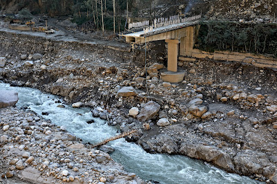
The remnants of Sikkim Urja dam which collapsed in the GLOF on 04Oct2023. Photographed on 18Nov2023, when we visited Chungthang.
A double laned concrete bridge connecting Chungthang to the rest of Sikkim was destroyed by the GLOF here on 04Oct2023

Munshithang (27.6324° N 88.6157° E)

Munshithang, an ammo depot for the Indian army was totally destroyed by the 04Oct Teesta Valley GLOF. On receiving warning of the rising waters in the Lachen Chu, 92 personnel of the ammo depot moved to  higher ground and thus their lives were saved. However, it was 4 days before they could be evacuated - due to bad weather which prevented helicopter flights.
Nothing could be retrieved of the ammunition and equipment lost to the GLOF.

Toong bridge over the Teesta river  (27°33'0.15"N 88°38'35.17"E)

We visited this area on 19Nov2023 and photographed the bridge and the Toong checkpost both of which were destroyed by the GLOF (below)

There was only a small bamboo bridge across the Teesta for pedestrians to cross the river on foot in Nov2023
The Toong police checkpost had been vacated and dangled precariously from the edge of the road
Another view of the vacated police checkpost in Nov2023
Faced with the sheer necessity of communicating, the local community start constructing a wooden bridge across the Teesta at Toong.

 Naga Gram Panchayat (Mangan district, North Sikkim)

Naga GP is located approx 14km from Mangan (district HQ of N Sikkim district) towards Toong and was one of the worst affected areas when we visited Chungthang on 19Nov2023.

It continues to be a wrecked and desolate place as can be seen from the recent photos (of Dec2024) below (photo credits: Rinchen Lama, IIHS ,Bangalore)
Google Earth has unfortunately not updated satellite images of areas south of Naga area (North Sikkim) which are still of 2022 vintage as such they do not show the impact of the GLOF in these areas.


Praful Rao
SaveTheHills
savethehills@gmail.com
9475033744

Monday, November 18, 2024

Community-Led Call to Action: 290 Signatures urging Immediate Disaster Mitigation in the Teesta Valley submitted by Darjeeling Himalaya Initiative and SaveTheHills


The following memorandum signed by 290 persons from Kalimpong, Darjeeling, and Sikkim has been submitted by Darjeeling Himalaya Initative and SaveTheHills to the Chairs of the NDMA, SDMA W Bengal and SDMA Sikkim:
_______________________________________

The Teesta Valley GLOF Disaster of October 2023: Impacts and Urgent Mitigation Needs Ahead of the 2025 Monsoons.

The Glacial Lake Outburst Flood (GLOF) and the subsequent hydro-power dam breach in the Teesta Valley in October 2023 brought widespread devastation, leading to tragic loss of life, severe damage to livelihoods  and assets as well unaccounted ecological devastation across Sikkim and West Bengal.

The disaster caused significant destruction to the National Hydroelectric Power Corporation’s (NHPC) infrastructure, agricultural land, forests, riverine ecosystems, transportation routes, and even critical military installations (Much of the devastation caused by the GLOF is documented in SaveTheHills’ blog http://savethehills.blogspot.com) Yet, despite the scale of the disaster, the response from state and central authorities have been inadequate, especially long term rehabilitation and restoration interventions at the relief, infrastructure and ecological level.
To further elucidate, we cite the case of fifty six families in the Teesta Valley (Kalimpong district)  who were displaced by the floods in Oct2023 and still continue to reside in relief centres. For these people who depended on the river for their survival, displacement has worsened their economic stability, and every day existence becomes a struggle for survival. Prolonged uncertainty worsens their mental distress, highlighting the urgent need for targeted interventions to restore their houses and livelihoods.
NH10, the lifeline of Kalimpong and Sikkim remained perilously unstable for much of the monsoons season and diversion of traffic from Sikkim via alternate routes added avoidable burden on transport services, infrastructure as well as the communities along the route.These vulnerabilities were exposed again almost throughout 2024 monsoon season and has severely reduced the tourist traffic to the region impacting  the economy of the Sikkim and Darjeeling Himalaya.

With only six months remaining before the 2025 monsoon, there is an urgent need to implement both structural and non-structural mitigation measures throughout the Teesta Valley. Effective action now can significantly reduce the impact of future floods, as such the implementation of these measures both in Sikkim and West Bengal in the valley is a vital necessity.
Central assistance will be imperative simply because the scale and complexity of the problem cannot be tackled at the state level.
The important issues at hand are listed below:

The Case for a Joint Sikkim-West Bengal Committee on Teesta Valley Flood Management

The October 2023 GLOF was one of the most severe glacial floods in the history of the Himalaya, affecting both Sikkim and West Bengal and needs to be responded to at a landscape level that is inclusive of both states. Each monsoon season, the Teesta River poses serious threats to both states, making collaborative management of the river and its surrounding regions essential.
A joint committee from both the states could address common issues and implement coordinated disaster management strategies that benefit both states.

Formation of an Expert Task Force

A dedicated task force of experts, drawn from geo-hydrology, environmental science, engineering, and sociology, should be formed to tackle the many challenges brought about by the GLOF. This task force must develop a comprehensive action plan that includes technical, financial, and social solutions for restoring and fortifying the region.

Structural Mitigation Measures

Construction of Embankments, Protection Walls, and Barriers

Embankments and barriers are urgently needed in low-lying, high-risk areas to prevent river overflow into settlements. Populated areas in the valley which are particularly vulnerable to flooding such as  those below the Teesta bridge along the Darjeeling-Kalimpong road, must be identified and remedial engineering solutions applied.

Channeling the River Flow

The natural flow of the Teesta River was disrupted by debris buildup from the GLOF, leading to riverbank overflow. The river must be re-channelized to prevent further damage to urban areas and infrastructure. Experts in fluvial geo-morphology and hydrological engineering can assist in deepening, widening, and redirecting the river to safer channels. NHPC’s technical expertise can be instrumental in this effort.

Road Engineering and Restoration

NH10, the key highway linking Siliguri and Gangtok, suffered extensive damage during the GLOF, resulting in economic losses and supply chain disruptions. Immediate restoration of this critical artery must be prioritized, along with repairs to alternative routes that have also deteriorated due to increased traffic and monsoonal impacts.

Bridge Repair and Reconstruction

The destruction of bridges in Sikkim and West Bengal has cut off many communities, hindering both economic activity and disaster relief efforts. Repair and reinforcement of these vital structures must be completed before the next monsoon season.

Reinforcement of Evacuation Centers and Relief Camps

Many evacuation centers and relief camps need urgent repairs and enhancements, such as backup solar power, to ensure they remain operational in the event of future emergencies.

Non-Structural Mitigation Measures

Early Warning Systems (EWS) and Communication Networks

Installing automated flood early warning systems (FLEWS) that deliver real-time alerts through sirens and mobile networks is crucial. Backup communication methods, such as ham radios and walkie-talkies operated by trained personnel, should also be implemented to ensure effective communication during emergencies.

Land-Use Planning and Zoning

Certain low-lying areas will remain high-risk zones even with structural protections in place. These areas should be designated for potential evacuation and resettlement of at-risk communities. Adequate compensation as decided by the expert group should be provided to affected victims and necessary support given to those relocating.

Public Awareness and Community-Based Disaster Risk Management (CBDRM)

Community preparedness is essential to build capacities and resilience during disasters. Awareness campaigns should educate residents on flood preparedness, evacuation procedures, and available insurance schemes. Additionally, evacuation drills must be regularly conducted to ensure communities can respond swiftly during emergencies.

Post-Disaster Financial Recovery Support

To aid in economic recovery, education on flood insurance and financial aid should be provided to residents and businesses, ensuring they have the tools to rebuild after a disaster.

Aggressive Afforestation Program

The GLOF caused widespread destruction of forests along the Teesta Valley. An aggressive reforestation initiative is needed to restore the valley’s ecosystem, prevent soil erosion, and help regulate the river's flow.

Conclusion

By implementing these crucial structural and non-structural mitigation measures, the Teesta Valley can be better prepared to withstand future monsoonal floods, protecting both lives and livelihoods. Urgent and coordinated action in the coming months is essential to prevent another disaster on the scale of the 2023 GLOF. The time to act is now, before the monsoons of 2025 arrive.

________________________________

We will submit the Memo to other officials as well.

Our thanks to all those who volunteered in making this community initiative possible

Praful Rao
Darjeeling Himalaya Initiative & SaveTheHills
9475033744

Roshan Rai
Darjeeling Himalaya Initiative
9932024812


Wednesday, February 14, 2024

Impact of the Teesta Valley Glacial Lake Outburst Flood (GLOF) - updates from North Sikkim (Feb2024)

As has been reported by us in this blog, the GLOF disaster of Oct2023 devastated large parts of the Teesta valley both in Sikkim and W Bengal. Placed below are some recent updates from North Sikkim:
Naga area of Mangan district
The devastation in Naga and Toong area of Mangan district has been covered here.
Recent (09Feb2024) closeup photos of landslide affected areas of Naga are shown below:

A telephoto image of the same area which I took from the opposite hill on 18Nov2023 (below) reveals hardly any change in the intervening 3 months.

As per my source in Chungthang, people from these homes have evacuated and are living with relatives or at rented places.
Toong bridge and road status
The GLOF of 04Oct2023 destroyed the bridge over the Teesta river at Toong (see photo of 18Nov2023 below). This bridge connected Mangan (dist HQ of North Sikkim) with Chungthang

A 'log' bridge (below) built in this area has temporarily restored this communication route.
However, for the time being the bridge is closed between 10.00am to 4pm to allow road repairs as such commercial vehicles and others still have to route via a long route via Saffo- Shipgyer - this route not only takes double the time but is narrow and dangerous at places.
As per information received, the progress of repair of Chungthang - Mangan road and also the Chungthang - Lachen road is slow and this is worrisome since the pre-monsoon season accompanied by intense thundershowers are due to start in March 2024.
Here are some rough stats:
a. The freight charges for a truck with 10 tonnes of load from Siliguri to Chungthang was approximately Rs22,000/- (incl of taxes), when the main roads were available.
b. Now, since the main roads are not available, the detours have pushed up the freight charges to Rs 31,000/- and also the trucks can only carry 8-9 tonnes of material on the alternate route.
c. So because the freight charges have increased while the load which is being carried has decreased - a single brick in Chungthang now costs Rs18.
Chungthang town
Among all the urban centers impacted, the GLOF dealt it's severest blow to Chungthang town at around 12.35am on 04Oct2023. We have covered it in detail here
Even when we visited the town on 18Nov2023, more than a month after the devastation, the whole place still looked like a war zone but I am glad to know that the people of Chungthang are slowly getting back on their feet again. Placed below are recent images of Chungthang town where the almost 10 feet of sludge mud and sand which buried the streets, homes and buildings have been cleared off and shops are open and life is slowly getting back to normal.

Praful Rao
Kalimpong district
Darjeeling- Sikkim Himalaya
savethehills@gmail.com
9475033744