Showing posts with label West Bengal. Show all posts

Wednesday, November 15, 2023

Photographic record of the impact of 04Oct2023 GLOF at Melli bazar and its vicinity -13Nov2023


Melli (27 05 24.2 N 88 27 29.6 E) Elev 232.9m, is a place which straddles the Teesta river. In South Sikkim, it is a small town, whereas in W Bengal (Kalimpong district) it is a transit place on NH10, Kalimpong district ,W Bengal.
We visited Melli during our survey of Teesta bazar on 10Oct2023 but could not access Melli (Sikkim) because the road from the bridge to the Melli town was closed to traffic.
On 13Nov2023, more than a month after the GLOF event I could make it to Melli town (Sikkim) with Prof Malay Mukul (Dept of Earth Sciences, IIT Bombay). Malay is from Kalimpong and was on a brief vacation here. These are some images from our visit on 10Oct2023:
Drone image (by Praveen) of the Melli ground  and stadium with the Teesta river nudging the edges of the complex.
Shredded parts of NH10 with a view of Melli town (Sikkim) from the opposite bank.
An excavator had started removing sand and sludge from the stadium on 10Oct2023.

Images from our visit on 13Nov2023 to Melli.
A dumper at the Melli ground belonging to SML company had been excavated along with the first floor of the several buildings at the rear.
The wreckage of another vehicle lay at the edge of the Melli stadium. Excavation of the sand, debris and sludge was continuing but seemed a humongous task considering the almost 10-15feet of sand that was dumped everywhere. Prof Malay Mukul can be seen in the background taking some readings.
Another view of the Melli stadium with buried vehicles strewn all over. Notice how close the river had come to the main town during the GLOF. In the distance and across the river is the IRCON railway tunnel.
This was the area which was most affected in Melli town (Sikkim) by the GLOF event.
A sombre Milan Gurung (48yrs) stands at his home near the Melli stadium with the Teesta river lapping up the edges of what used to be his front yard. He told us that 3 new vehicles from SML company were swept away here along with a large liquor storehouse.
He squarely blames the inundation of his home on the dumping of excavated tunnel material on the opposite bank by the IRCON project. He says the river first hit the huge IRCON debris on the opposite bank and rebounded from it, to flood his home and 10 houses around the stadium.
Milan Gurung told us the river was never so close to his home earlier and was fearful about living here now.
Debris at the opposite end of the stadium.
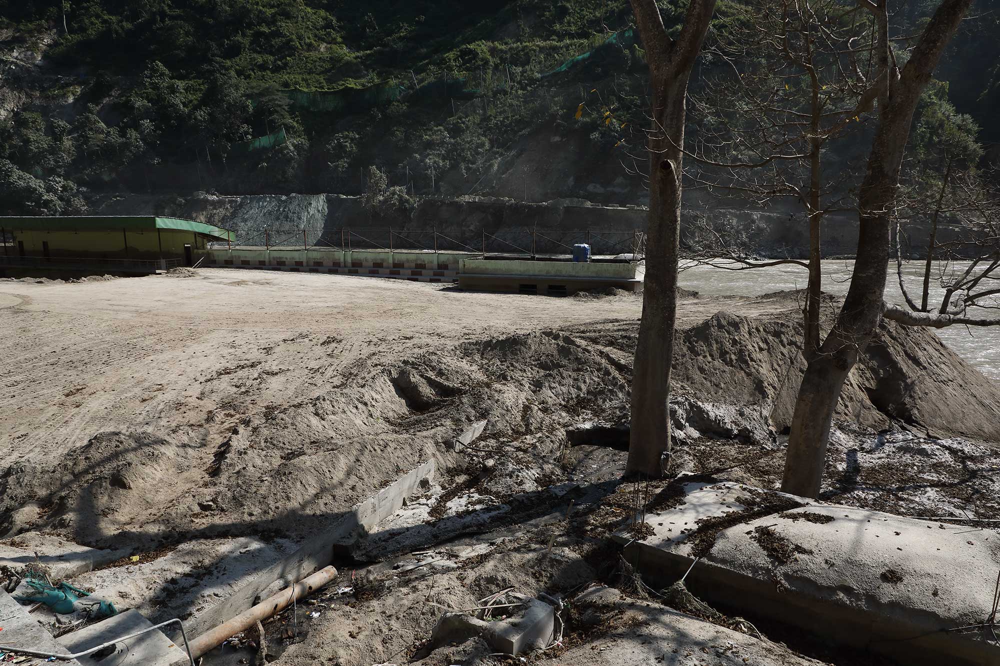
Residents of this area said the sewage treatment plant of Melli town was located here and it was either swept away or buried.
Dangerously poised GLOF affected buildings on the W Bengal side of Melli Bazar.
The problem is that there are so many weakened structures like these, everywhere with the river nibbling away at the base.

Images of Tribeni (at the junction of Rangeet and Teesta rivers)

Image of the GTA Covid Hospital at Tribeni on 10Oct2023.
Image of the GTA Covid Hospital at Tribeni on 13Nov2023.
Rangeet river water is distinctly green whereas that of the Teesta is still laden with silt and brown.
Road to GTA Covid Hospital at Tribeni on 13Nov2023
A large section of road (approx 300m) from Teesta bazar  to the GTA Covid Hospital at Tribeni is still submerged - with the river having regained its lost territory.
The river submerges the road here (27 04 6.8 N 88 25 39.7 E) just 10 mins walk from the Teesta bazar. Sadly, this place has now become a dumping ground for solid waste.

The road remains under water for a long time until it reaches here (27 04 14.4 N 88 25 49.2 E) where it climbs out of the river.

My thanks to Prof Malay Mukul for taking time off to visit these places. I will update his inputs in a separate blogpost.

Praful Rao
Kalimpong district
Darjeeling-Sikkim Himalaya
savethehills@gmail.com
9475033744


Friday, October 13, 2023

Photo essay on Glacial Lake Outburst Flood (GLOF) of 04Oct2023: the Kalimpong chapter

The GLOF of 04Oct2023 from Lhonak Glacier affected down stream areas in Kalimpong district (W Bengal) as well. As on date, three people are confirmed dead and thirteen people missing, most of these figures coming from the W. Bengal side of Rangpo.
However, many of the low lying areas along the path of the river were severely affected and residents of Teesta bazaar recounted how a swollen river had suddenly barged in, in the darkness and in pouring rain at around 3am on 04Oct2023.
Kalimpong recorded 147mm rain on 04Oct2023.


On 10Oct2023, we (Praveen of Junkeri Studios, his team and I) reached Teesta bazaar which is around 15kms from Kalimpong and spent almost 6hrs there and at Melli and Bhalukhola (See map above). We could not see other places such as Geil Khola or Tribeni because the roads are simply non existent:
* Road towards Siliguri - damaged at Rabi jhora and Likhu bhir. *Road to Darjeeling and Teesta bazaar - still under Teesta waters at the NH10, Darjeeling road bifurcation.* Road to Tribeni damaged at numerous places from Teesta bazaar to Tribeni. * NH10 towards Gangtok - precarious at many, many places, even tho it was open at that time.
Relief camp details as on 11Oct2023 are given above. Many more are staying with their friends and relatives in the vicinity.
Loss of livestock also has been a major issue with countless pigs, cattle, poultry and goats being swept away by the floods.
What struck us on reaching Teesta was the sheer size and swiftness of the river even after 6 days of the GLOF and the amount of debris/sand and sediment the river was still carrying.I wondered how this was possible? since it was not raining heavily in North Sikkim.
This is the road to Darjeeling at Teesta bazaar.
With the river still flowing from one bank to the other and at much higher level (because of the silt deposit), parts of the road to Darjeeling are still submerged.
A dog lazily scratches himself, while sitting on the roof of a home which is still under water at Teesta bazaar. We were told that 45 homes had been damaged or destroyed in this area. Notice the water level is almost at the same level as the road. We observed this everywhere - the water level has gone up dramatically, even as much as 20-30 feet and now the river is flowing much closer to populated areas and the railway tunnels.
Sunayana Devi stands on the roof of what was earlier her kitchen. Half of her three storey structure is now filled with sand and the sudden invasion by the flood waters prevented them from saving anything. Like many so many others we spoke to, she wants the government to relocate her to a safer place.
An elderly lady and two young relatives check the damage to their home in Teesta bazaar. The river is today just a few meters away from their home which itself is dangerously cracked. - photo by Praveen.
The ferocity of the flood waters is unimaginable - the Teesta dumped 10-15 feet of sand on these two vehicles (and everything else) in its 3 hour rampage at the center of the bazaar. We were lucky this time - our casualty figures are far less than what was expected.
Volunteers clearing up in Teesta bazaar take a break from their work - photo by Praveen.
Remains of a brand new resort in Teesta Bazaar after the GLOF. Huge chunks of whatever is seen in this image are cracked and dangerously tilting towards the river - photo by Praveen.
Even though not many lives were lost, the GLOF wreaked havoc on the infrastructure in the 3-4 hour event. All this comes at a time when people of this region are looking forward to celebrating the festive season ahead - photo by Praveen.
A priest and a devotee perform a puja on the banks of the Teesta perhaps to pacify the river Gods. The river looks deceptively calm.
Fresh rations stock at Melli bazaar (W Bengal side).
The worst affected here were the two shanty colonies (located below the Melli bridge) which comprised of almost 30 odd homes. Nothing remains except a solitary, sand covered Masjid where the the predominantly Muslim dwellers used to worship.
As with others, a victim wanted the government to swiftly shift them to a safer location.
At most places we visited, there was no shortage of food or clothing for the time being - but winter is nigh and these people will need sustained care to help them recoup.
Drone image by Praveen of Melli stadium (Sikkim) covered with sludge. Do notice at where the Teesta is flowing.
Teesta stomps into the courtyard of the Tribeni Covid Hospital.
This large structure was used as the GTA Covid Hospital during the pandemic and is extensively used by tour operators to entertain tourists even overnight. Luckily no one was around when Teesta came calling on 04Oct2023 at 3am.
One can see quite a lot of damage in the right flank of the building in the drone image by Praveen (below).
NH10, opposite Melli town.
The GLOF of Oct2023 together with the dam operations is going to make NH10 maintenance a headache. Numerous places along the NH10 are subsiding and this makes driving at night on the highway even dangerous.
Another image by Praveen of the damage to NH10 is below
The UCNI church at Bhalukhola, near Melli. This is low lying area which was flooded during the GLOF.
The living room of a home at Bhalukhola - an entire lifetime's earnings have been reduced to sludge and mud covered trash- Photo by Praveen
There was a shanty colony here in Bhalukhola, which has been swept away by the flood. The more permanent structures have survived but will need extensive repair.
But looking at the proximity of the river and the elevated level at which it is flowing, will anyone risk returning to these homes? Photo by Praveen.

An after thought and a sense of deja vu
I find it strange that on 10Oct2023, I did exactly the same thing I did from the same spot, 55years ago in Oct1968 - that is, photograph the devastation caused by a raging river from the opposite bank of the Teesta.
I have written about it here
 
Update on 16Oct2023: Teesta-Darjeeling road open 'but repairs still going on', as reported by Mr Soam Namchu of Glen Family Foundation today in STH Whats App group 'Hazard Alerts'
Photo credit: Soam Namchu


Again, my gratitude to all those who helped make this documentation possible.


Praful Rao
Kalimpong district
Darjeeling - Sikkim Himalaya
savethehills@gmail.com
9475033744

Tuesday, August 22, 2023

Working at the grass roots: An Anugyalaya (DDSSS) workshop on disaster risk with panchayat level people in Kalimpong (22Aug2023)

Generating awareness on disaster risk especially with rural people has always been our forte and yesterday we had the opportunity to talk with 70 odd people mainly from Sindebong and Bhalukhop bustee (village) areas. 

Among them were many of the newly elected gram panchayat members, members of the samaj (community), ASHA workers and SHG heads of the 2 villages.
I had shared the 3 hour event with Ms Kaveri Subba, BDMO ( Block Disaster Management Officer) of Kalimpong Block -1 (seated with me in front) and the workshop was moderated and organized by Ms Aachal Tamang (extreme left), member of both SaveTheHills and Anugyglaya DDSSS.

Praful Rao
Kalimpong district
Darjeeling-Sikkim Himalaya
savethehills@gmail.com
savethehills.blogspot.com
 

Wednesday, May 20, 2020

Super Cyclone Amphan makes landfall in the vicinity of Kolkata: 20May2020 (1430hrs onwards)

Source:https://en.allmetsat.com/metar-taf/india-nepal-bhutan-bangladesh-burma.php?icao=VECC

Tracking the Beast

Was declared a Cyclonic Storm 'Amphan' on 16May2020, after which it rapidly intensified in Severe Cyclone. STH posted continuous updates on the tracks of the storm

RSMC, Delhi and JTWC issued some 33 advisory bulletins and 18 warnings respectively from 15May until the storm made landfall exactly as predicted on 20May near Kolkata
First track forecast and the final track observed are placed below:
Rainfall

Fact Sheet:
·        * Landfall process started at around 1430hrs/20May2020 between Digha and Hadia islands as predicted and passed thru the Sunderbans between 1530hrs to 1730hrs.
·       *  Wind speed at the time of landfall and crossing coast 155kmph and going up to 185kmph in gusts. Max recorded windspeed in Kolkata, from observatory at Dum Dum was 130kmph at 1855hrs on 20May.
·        * Windspeeds in Kolkata started increasing from around 1700hrs, max windspeeds were around 1900-1920hrs after which the speeds became less. Max winds were felt between 17-2100hrs.
* Approx 5000 trees uprooted by the storm.
·        * Most impacts on South 24 Parganas and East Midnapur and then Kolkata, Howrah and Hooghly districts.
·        * Was tracked continuously by DWR along the East Coasts which could give accurate information on intensity, landfall point and time, associated weather, storm surge, heavy rain and winds at different districts.
·       *  Heavy to extremely rain was observed in all the affected areas. 24 hrs rain in Kolktata (Alipore) 240mm, Dum Dum 200mm.
·       * After hitting Kolkata, the storm moved in a NNE direction and crossed the Bangladesh border at 2330hrs and became a deep depression in Bangladesh on 21May2020.
·       * Windspeeds in Meghalaya were 60kmph on 21May2020 and affected the NE States thereafter.
    
 STH cautionary advice (printed by media days prior to the storm):

 Images from the SUNDERBANS


           Praful Rao
     Kalimpong district
     Darjeeling - Sikkim Himalaya