Showing posts with label NIDM. Show all posts

Saturday, June 19, 2021

Rainfall data (April 2021 and May 2021) of some towns of the Darjeeling - Sikkim Himalaya, STH activities, Cyclone 'YAAS' and the Landslides

April 2021 rainfall

May 2021 rainfall

STH Activities

1. NIDM webinar
Participated in a national level webinar organized by NIDM on 'Capacity Building among Rural Communities' where I spoke on STH experience in working with rural people and the dire necessity of 'Community Based Disaster RIsk Management' (CBDRM)

2. Reporting on Cyclone 'YAAS'


We kept a close track on Cyclone 'YAAS', the first cyclone to form in the Bay in 2021 from the time it formed in the Bay until it dissipated. The track and position was reported extensively in the STH WhatsApp Group 'HAZARD ALERTS' which has a large following in our region.

3. Keeping a tab on the landslides
It goes without saying that any major weather event in the Bay will impact the mountains of  the Darjeeling- Sikkim Himalaya which are barely 600km north of the Bay of Bengal - and so it was with Cyclone YAAS. The rainfall activity in our region spiked between the
25-28May2021 and it caused a number of landslides in Sikkim as well as the hills of Darjeeling/Kalimpong.
Some of the landslides have been documented here


Praful Rao with Ms Shreya Gurung
Kalimpong district
Darjeeling Sikkim HImalaya


Tuesday, June 18, 2019

Flood scare in Sikkim and Kalimpong district (W.Bengal) - 17Jun2019


The Darjeeling - Sikkim Himalaya has thus far had very deficient in rainfall (see below)

 The SW monsoons finally arrived over the Darjeeling Sikkim Himalayas on 16Jun2019 almost 10 days late and we had relief from the heat here when there was a smattering of rainfall given by clouds shown:

Rainfall figures for 16/17Jun2019 are given (source IMD):

So I was rather surprised when we started getting flood alert messages from Sikkim on 17Jun afternoon on WhatsApp, that due to a 'cloud burst' in North Sikkim, the level of the Teesta river was rising dramatically and parts of Singtam (Adarsh Gaon), a business town one hour short of Gangtok and other low lying areas along NH10 were in danger.
Having kept a close look on the weather and rainfall of the region, which was nowhere near extreme, I personally feel that the dams at Chungthang and Dikchu in Sikkim had released large volumes of water after the rains which resulted in the Teesta river level rising sharply. I am aware that most of these dams are run-of-the-river dams, yet considering the steep descent path of the Teesta river and its turbulence, I do believe the volumes of water released caused the flood-like situation.
In this regard, I refer readers to the Youtube video below:


Updates on the above event:
Rainfall data of 17/18Jun (0830hrs to 0830hrs) available now:
Sankalan: 140mm
Mangan: 70mm
Chungthang: 50mm

(Source IMD)

Praful Rao,
Kalimpong district,
Darjeeling-Sikkim Himalaya


Friday, May 2, 2014

STH activities: Training workshop on Earthquake and Landslide Management at ATI Kolkata (28-30Apr2014)


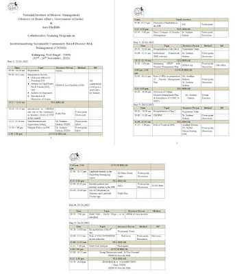
28-30Apr2014 - The Administrative Training Institute (ATI), in collaboration with the National Institute of Disaster Management (NIDM) organized a training workshop on 'Landslide and Earthquake' Management in Kolkata. The training covered many important aspects such as structural and non-structural mitigation measures, the Incident Response System, community based preparedness to build resilience, landslide and earthquake vulnerability in West Bengal etc. 

Rohan Rao,
Secretary,STH,
Kalimpong,
Dist-Darjeeling,
Email-sth.scretary@gmail.com