Showing posts with label debris. Show all posts

Thursday, December 19, 2024

A post GLOF look at the Teesta bazar and its vicinity (Part -1)

A few days ago, a friend called from Mangan, the headquarters of North Sikkim district, eager to witness the aftermath of the Teesta Valley Glacial Lake Outburst Flood (GLOF) that occurred on October 4, 2023. She expressed difficulty in identifying the affected areas. I empathized, recalling how we began documenting the disaster through photographs and recordings on the very day it happened.

Over a year has passed, including a full monsoon season. During this time, nature has altered the landscape, roads and homes have been repaired, and damaged machinery and assets have been removed or replaced. These changes underscore the importance of promptly documenting disasters, at least through photography, to capture the immediate impact before recovery efforts and natural processes transform the scene.

The Glacial Lake Outburst Flood (GLOF) on October 4, 2023, caused the Teesta River's level to surge by approximately 3 to 4 meters throughout the valley. This event deposited substantial silt and debris along the river's course. While monsoon floods have since washed away some of these deposits, the river is gradually reestablishing its natural channel—a process that can span several years. Consequently, we must brace for potential challenges during upcoming monsoon seasons. The current dry season offers an ideal window for implementing necessary preparations; however, I have observed a concerning lack of such proactive measures and towards this end we have voiced our concern by writing to the highest levels in the country.

With regard to the disaster, I made a visit on 18Dec2024 to the Teesta bazar and its vicinity to check and photograph the area. My report:

a. River Condition:
The Teesta River has shed much of the silt and debris left by the October 2023 GLOF and is regaining its characteristic emerald-green winter hue. In some areas, the river has carved out a defined channel, reducing its erratic flow over the 3-4 meter thick debris layer deposited during the disaster.

b. Disaster Mitigation Efforts:
No visible disaster mitigation efforts were underway in Teesta Bazar or its surrounding areas. Residents I spoke to expressed deep frustration over the lack of action.

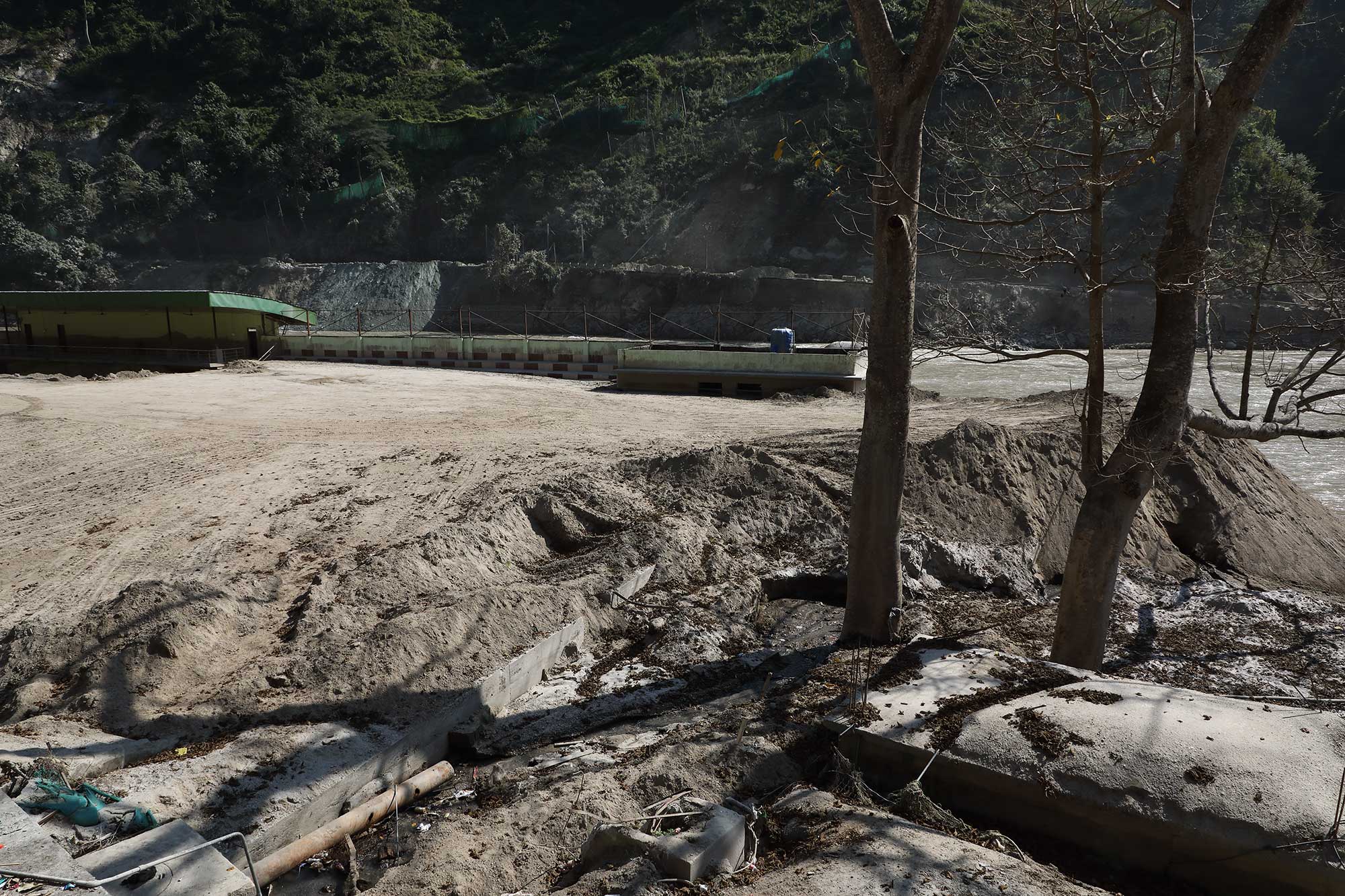
c. Local Economy - Rafting Resumes:
Rafting activities have resumed in the Teesta/Labar Boatay area, providing direct and indirect employment to approximately 2,000 people.

d. Tribeni Covid Hospital:
A footpath to the Tribeni Covid Hospital is functional. However, much of the hospital's infrastructure has been either looted or washed away by the floods, leaving it in a dire state.

e. NH10 Road Conditions:
On the short stretch of NH10 I traveled, significant repair work was underway near Likhu Bhir. However, areas around the 29th mile and Melli remain vulnerable, with visible cracks and sinking sections near the riverbank. These areas are at serious risk of collapse during the next heavy rains.
Placed below are images of the area:


Documentation of parts of the above report was supported by Royal Enfield, as part of their Social Mission Initiative


Praful Rao
SaveTheHills
savethehills@gmail.com
9475033744

Wednesday, April 3, 2024

Views of the Teesta river after Cyclone Aila (May2009) and after the GLOF (Oct2023)

During our talks with GLOF affected people in the Teesta valley, they say that many officials, politicians and others often ask them why they built their homes so close to the river; to which they answer, 'No, we never built our homes close to the river - it is the river which has now come close to us!'

When I relate this during my talks on the Teesta valley GLOF, it often draws laughter from the audience - not realizing that I wholly share the views of the affected people:

The Teesta river which was once quite far from settlements has now moved closer to homes, roads and urban areas.

I visited the Teesta river on 11Jun2009, soon after Cyclone AILA (25-27May2009) and took photos of the river from the Teesta bridge. There were no dams those days but the river was still quite big because of the SW monsoons and Cyclone AILA.

After the Oct2023 Teesta Valley GLOF, again we made numerous trips to the Teesta river and photographed the river from almost the same spot on the bridge 14years later. I have placed both below for you to see how the river has moved closer to people's homes

Facing south (towards Siliguri)
Teesta, shortly after Cyclone AILA in Jun2009. Notice the level of the river visavis the Kalimpong to Darjeeling road on the right. The river was free flowing those days since the major dams on the Teesta were yet to be built.
Teesta river after the Oct2023 GLOF. Rainfall in our area totally stopped after 04Oct2023 (when the GLOF occurred) but the silt deposits had increased the river level as such it was flowing almost at the same level as the Kalimpong to Darjeeling road (on the right)

Facing north (towards Gangtok)
Cyclone AILA (27May2009) heralded in the SW monsoons that year as such the river is still quite large. Nevertheless the Teesta Bazar (left side) was not touched by the river even during Cyclone AILA
Our entire region had drought like conditions since the GLOF in Oct2023, yet the river stretches from one bank to the other and is flowing very close to homes in the Teesta bazar (left). The river is brown and loaded with silt and debris which is being dumped into the river by people excavating their homes and belongings all along the valley and also by the tunneling being done by the railway project. All in all the level of  the river bed has increased by 3-4m after the GLOF.

A makeshift road has come up on the right bank and leads to the new IRCON railway bridge being constructed next to the existing one.

Praful Rao
Kalimpong district
Darjeeling-Sikkim Himalaya
savethehills@gmail.com
9475033744

Wednesday, November 15, 2023

Photographic record of the impact of 04Oct2023 GLOF at Melli bazar and its vicinity -13Nov2023


Melli (27 05 24.2 N 88 27 29.6 E) Elev 232.9m, is a place which straddles the Teesta river. In South Sikkim, it is a small town, whereas in W Bengal (Kalimpong district) it is a transit place on NH10, Kalimpong district ,W Bengal.
We visited Melli during our survey of Teesta bazar on 10Oct2023 but could not access Melli (Sikkim) because the road from the bridge to the Melli town was closed to traffic.
On 13Nov2023, more than a month after the GLOF event I could make it to Melli town (Sikkim) with Prof Malay Mukul (Dept of Earth Sciences, IIT Bombay). Malay is from Kalimpong and was on a brief vacation here. These are some images from our visit on 10Oct2023:
Drone image (by Praveen) of the Melli ground  and stadium with the Teesta river nudging the edges of the complex.
Shredded parts of NH10 with a view of Melli town (Sikkim) from the opposite bank.
An excavator had started removing sand and sludge from the stadium on 10Oct2023.

Images from our visit on 13Nov2023 to Melli.
A dumper at the Melli ground belonging to SML company had been excavated along with the first floor of the several buildings at the rear.
The wreckage of another vehicle lay at the edge of the Melli stadium. Excavation of the sand, debris and sludge was continuing but seemed a humongous task considering the almost 10-15feet of sand that was dumped everywhere. Prof Malay Mukul can be seen in the background taking some readings.
Another view of the Melli stadium with buried vehicles strewn all over. Notice how close the river had come to the main town during the GLOF. In the distance and across the river is the IRCON railway tunnel.
This was the area which was most affected in Melli town (Sikkim) by the GLOF event.
A sombre Milan Gurung (48yrs) stands at his home near the Melli stadium with the Teesta river lapping up the edges of what used to be his front yard. He told us that 3 new vehicles from SML company were swept away here along with a large liquor storehouse.
He squarely blames the inundation of his home on the dumping of excavated tunnel material on the opposite bank by the IRCON project. He says the river first hit the huge IRCON debris on the opposite bank and rebounded from it, to flood his home and 10 houses around the stadium.
Milan Gurung told us the river was never so close to his home earlier and was fearful about living here now.
Debris at the opposite end of the stadium.
Residents of this area said the sewage treatment plant of Melli town was located here and it was either swept away or buried.
Dangerously poised GLOF affected buildings on the W Bengal side of Melli Bazar.
The problem is that there are so many weakened structures like these, everywhere with the river nibbling away at the base.

Images of Tribeni (at the junction of Rangeet and Teesta rivers)

Image of the GTA Covid Hospital at Tribeni on 10Oct2023.
Image of the GTA Covid Hospital at Tribeni on 13Nov2023.
Rangeet river water is distinctly green whereas that of the Teesta is still laden with silt and brown.
Road to GTA Covid Hospital at Tribeni on 13Nov2023
A large section of road (approx 300m) from Teesta bazar  to the GTA Covid Hospital at Tribeni is still submerged - with the river having regained its lost territory.
The river submerges the road here (27 04 6.8 N 88 25 39.7 E) just 10 mins walk from the Teesta bazar. Sadly, this place has now become a dumping ground for solid waste.

The road remains under water for a long time until it reaches here (27 04 14.4 N 88 25 49.2 E) where it climbs out of the river.

My thanks to Prof Malay Mukul for taking time off to visit these places. I will update his inputs in a separate blogpost.

Praful Rao
Kalimpong district
Darjeeling-Sikkim Himalaya
savethehills@gmail.com
9475033744