Showing posts with label subsidence. Show all posts

Tuesday, July 23, 2024

Impact of the Teesta Valley GLOF: Photo feature on Krishnagram - a sinking zone in the Teesta Bazar (21-22Jul2024)

While we (Junkeri Studio with SaveTheHills) have featured this area as a part of numerous surveys of GLOF affected areas done in Oct2023, both of us visited the Krishnagram area of Teesta bazar again between 21-22July2024.

Bhasuwa (27 03 41.7 N 88 25 29.2 E, Elevn 248m) as the name implies, is a sinking area but the rate of subsidence increased dramatically after the Oct 2023 GLOF raised the Teesta river levels by 4-5m. The river now flows very close to Bhasuwa and as such the erosion at the base of the mountain and subsidence has increased. The place was renamed Krishnagram.
While reporters, politicians and engineers visit the destruction along the Darjeeling-Kalimpong road at Krishnagram, not many are aware of the plight of villagers living directly above the area. Here, a paralyzed elder brother lies on the floor of Mrs Ganga Sarki's (age 55yrs) home. She reports a numbing sense of desperation with nowhere to go, as her home falls apart.(Photo: Praveen)
A woman stands in her home which is rapidly being destroyed as a part of the hill at Krishnagram slowly slides into the Teesta river. Residents report being scared of the nights and of the terrifying sounds they hear as the cracks widen and nails come off wooden beams.(Photo Praveen)
Villagers evacuating to safer areas with whatever moveable property they can salvage as the cracks on the ground and walls become bigger.
Around 15 homes are affected in the village directly above the road at Krishnagram (Photo: Praveen)
The Community Hall at Krishnagram (earlier called Bhasuwa) on 21Jul2024. This hall was used as a Relief Centre, with many families staying here during the GLOF disaster of 04Oct2023. 
The buckled up and destroyed interior of the Community Hall at Krishnagram on 21Jul2024. This hall had 9 families living here during and after the GLOF disaster of Oct2023.
A resident in the Community Hall which was used as a Relief Centre on 10Oct2023 when we visited Teesta bazar. The floor was severely cracked even then but the subsidence of the ground has increased now with the river running wild during the monsoons.
The severely depressed and slumping part of the Darjeeling-Kalimpong road at Krishnagram (earlier Bhasuwa).The Community Hall is on the left while the home of Mr Tika Karki is on the right side of vehicle. Tika Karki has abandoned his home and lives with relatives in the bazar while his home itself has nearly keeled over in the last 24hrs or so.
The Darjeeling-Kalimpong road was closed on 22July2024 afternoon, after the cracks on the road increased significantly and a large tree here fell, due to the ground instability.(Photo: Praveen)
Another new unstable area is this spot (27 03 38.7 N 88 25 29.7 E Elevn 239m) on the Darjeeling-Kalimpong road, in close vicinity of the Teesta police station - again due to elevated levels of the river (post GLOF). (Photo taken from inside vehicle hence the streaks)

Updated DRONE images of Krishnagram (Bhasuwa)


The image shows the most severely affected area of Krishnagram at Teesta bazar. The road leads to Darjeeling (to the right) as well as the business center of Teesta bazar which is also affected by the river.
The image shows subsiding areas of Krishnagram above the Darjeeling-Kalimpong road.
The entire sinking area of Krishnagram, with the Teesta river continuously eroding the base of the hill.
Praful Rao along with Praveen Chhetri
SaveTheHills,
savethehills@gmail.com
9475033744

Saturday, March 30, 2024

The National Highway 10 (NH10 - Siliguri to Gangtok) maintenance problem (post GLOF) begins in Mar2024

NH10 and Likhu Bhir in 2017 & 2023

MoRTH website on NH10
reads as follows:
'The highway starting from Indo / Bangladesh Border connecting Fulbari Siliguri in the State of West Bengal connecting Sivok, Kalimpang near N.H-10 and terminating at Gangtok in the State of Sikkim'. 52kms of the highway is in Sikkim, the remaining 65.97kms being in W Bengal.
Further to our earlier report on National Highway 10 (NH10), the recent rains in our region caused landslides along parts of NH10 which resulted in road blockages and traffic jams and as such the Kalimpong District Administration has closed parts of NH10 for traffic as per the letter below:


Prolonged closure of NH10 dates
Road closures for several hours on NH10 due to landslips, erosion and rockfalls etc are commonplace and take place almost daily during the monsoons. Prolonged closure dates of the highway in the recent past are as follows:-
* In 2007 and 11Jun2010 at HaatiSurey, near Coronation bridge – blocked for a week.
* 26Jun-03Jul2015 due to landslide at SetiJhora (near TLDP IV)
* 14-15Jan 2016 due to landslide at BhoteyBhir (near Rangpo)
* 06Jul2019 for almost a week at Seti Jhora

Despite several alternate routes now being available (see map below), NH10 remains the shortest distance with the least gradient changes and is the quickest way to commute from Sikkim and Kalimpong to SIliguri and the plains of North Bengal - however, it may not be the safest route anymore.

NH10 and alternate routes

DATA ON NH10 (and the alternate routes from Gangtok and Kalimpong to Siliguri)

Distances - Siliguri to Gangtok
Via NH10 - 114kms out of which approx 90kms is in mountainous terrain. Approx 60kms from Singtam to Sevoke is along the banks of the Teesta river.
a. Alternate route 1 (via Pakyong- Reshi-Algarah-Lava-Sevoke-Siliguri) - 241kms
b. Alternate route 2 (via Rangpo-Chitrey-Kalimpong-Algarah-Lava-Sevoke-Siliguri)  - 205kms

Distances- Kalimpong to Siliguri  
Via NH10 - 67kms
a. Alternate route 1 (via Ghoom -Kurseong) - 99kms
b. Alternate route 2 (via Algarah-Lava- Gorubathan-Sevoke) - 132kms
c. Alternate route 3 (across Relli river- Samthar- Panbu-Kalijhora-Sevoke)

It is estimated that approximately 3000 vehicles use the NH10 daily when permitted.

Images of landslide and traffic snarls in that part of the road
Rockfall at Likhu Bhir after rains on 23Mar2024
Traffic jam at Chitrey (Teesta) due to rock fall at Likhu Bhir, 23Nov2024
Traffic jam at Likhu Bhir on 24Jan2024 at around 6pm


As we have reported earlier, Likhu Bhir is an old landslide which was dormant for many years until the GLOF of 04Oct2023 reactivated it.
File photo from July2019

Also as reported, the Teesta river bed has risen by almost 4m all along the valley due to the silt and sand deposits brought down by the GLOF, which makes NH10 much more prone to subsidence/erosion (the TLDP III and IV dam activities and the IRCON tunnelling having contributed their share to making sections of NH10 more prone to subsidence, rockfalls and landslides)

Rainfall (at Kalimpong) from 19Mar to 23Mar2024
107mm.
It was surprising that very moderate rainfall, after almost 4 months of complete drought could trigger so much instability in the Likhu Bhir area.
Recently, I met a geomorphologist who said that the Oct 2023 Teesta Valley GLOF was the biggest such event in the Himalayas in the recent past. I believe him entirely.

My thanks to our WhatsApp group 'HA' members who's photos I have used :)

Praful Rao
Kalimpong district
Darjeeling-Sikkim Himalaya
savethehills@gmail.com
9475033744


Friday, January 13, 2023

Why we should tread softly in the Himalayas...Pakyong, Sikkim, Nov2017

While the sinking of Joshimath, in large part due to human activities has caught the attention of the nation, I was witness to a similar event in another Himalayan state,ie Sikkim caused by anthropogenic activity which has now been largely forgotten.

Pakyong airport, 30 km from Gangtok at an elevation 4590ft (1399m)was inaugurated by Prime Minister Narendra Modi on 24Sept 2018. It was constructed by the Airport Authority of India (AAI) at an estimated cost of Rs 605 crore and was touted be an "engineering marvel" for its soil reinforcement and slope stabilization techniques keeping in view the altitude it was built at. 

After inauguration, only Spicejet operated a Bombardier Q -400 on the Kolkata -Pakyong route and under Visual Flight Rules since there no navigational aids or radar at the airport which will permit IFR flight.

Building the airport caused severe distress to the slopes around the airport and the landslide problem in the area has been adequately documented by Dr Dave Petley in his blog here.

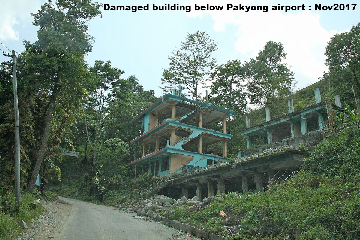
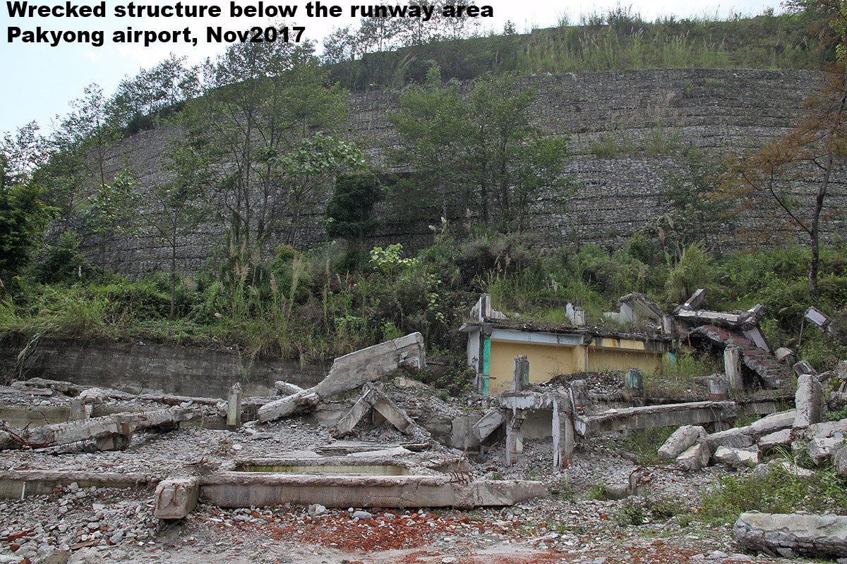
I visited Pakyong on 05Nov2017 and met some local contacts who said almost 164 buildings/homes large and small, located below and around the runway had been damaged due to the sinking caused by the airport construction.  

I have placed images of buildings being dismantled and other images of Pakyong airport below:


I took these photos in Nov2017 and after that I have not visited Pakyong. 

What I know from media reports is that adequate compensation has been doled out to all the affected people there so there is silence from that end.
What I am not sure is about the health of the mountain because I believe the runway is under repair/ extension.

No flights have operated to/from Pakyong for some time now, for reasons unknown to me.

Praful Rao
Kalimpong district
Darjeeling-Sikkim HImalaya
9475033744
savethehills@gmail.com


Friday, October 2, 2020

Arubotay - a village under threat of extinction from Landslides

Till yesterday, neither I nor anyone had heard of a tiny, obscure village called ARUBOTAY (which literally translates into 'Place of Plum Trees'). It is located in Majua GP, Block Office Bijanbari of Darjeeling district and if it doesn't grow plums, what it does grow is thousands of tons of squash.
Yes! agriculture is the mainstay and livelihood of people in Arubotay - that, along with tourism.
A few days ago I received a call from a friend asking me to visit the village and check the landslide situation there. I did that with STH member Ms Shreya Gurung and Mr Christopher Lepcha of Anugyalaya, a Darjeeling based Roman Catholic NGO.

A report:

1. Location : 27.01843N 088.14789E. Elevation: 1356m

2. Brief history of the landslide
I talked to several people of Arubotay who told me that the initial cracks and fissures had appeared on the hillock during the Sikkim earthquake of 18Sep2011 but many remarked their area was stable even during the mega-disaster of Oct 1968.
Thereafter, the region had remained more or less unscathed during the many intervening years . In 2020 however, the cracks had started 'growing' as early as July following heavy rain. One must note that there is also a fast flowing mountain river (Chota Rangit) below the Sacred Heart School, on the eastern flank of the hill. 
3. Landslide time and date:
The major landslide on the eastern face of the Arubotay ridge line and near the Sacred Heart School occurred at around 11.30pm on 23Sep2020, thereafter it continued on 24/25 Sep2020, when most of the instability and sinking in the village occurred. The landslide continues to be active even now.

Other data on the slide
a. Probable cause : Heavy rain and also erosion by mountain stream on the eastern flank
b. Size : Very large
c. Damage to property etc:
   i. The Sacred Heart School at Arubotay is being demolished since it is unsafe.
  ii. Around 26 homes totally damaged and 10 homes partially damaged
  iii. Loss of farmland - around 20 acres.
  iv. Road communication from Maneybhanjyang to Jorethang (Sikkim) has been cut
d. In all probability most of those who have lost their homes will have to be relocated as the mitigating or controlling the landslide appears impossible.

4. Rainfall data

Detailed rainfall records of our region are available in the STH blog. Day wise rainfall record of Sep2020 will be published in a week.
4. About Sacred Heart School
The new Sacred Heart School building donated by a Luxemburg NGO was inaugurated in 2011 and was run by the Roman Catholic Diocesan trust at Arubotay. The school was functional from much earlier and had 57 students, mostly from around the area, enrolled in 2020.
The building is being DEMOLISHED today.

Update 1
On 10Oct2020, the District Magistrate, Darjeeling accompanied by the GTA Chairman (seen above), visited the ARUBOTAY landslide area and among other things discussed the possible relocation of affected people. We also know that the GSI will be send their officials for a study of the area in a few days.
Update 2 (25Oct)
Two geologists from GSI visited the area around mid Oct2020 and have filed their report to the Darjeeling district administration, based on which the BDO Pulbazar has issued a notice for relocation of the residents of Arubotay. 

Our thanks to the community of Arubotay for their time and help during our visit yesterday and my sincere gratitude to Bishop Stephen Lepcha for his initiative and help.
Update 2
I received this letter from the Bishop, yesterday (16Jun2021):

Report by Praful Rao and Shreya Gurung
SaveTheHills