SaveTheHills(STH) is a group of concerned citizens who are raising awareness about landslides in Darjeeling-Sikkim Himalaya. Many landslides are the direct or indirect result of human interference and preventable if sufficient care is taken. As such, unless we begin a comprehensive and sustained program towards landslide management, prevention and mitigation, the consequences of ignoring years of human callousness will, in the future be devastating.
Thursday, September 5, 2024
Survey of parts of the Teesta Valley (Part I) in Sep2024 - Impact of a landslide on 20Aug2024 at NHPC Stage V Power Station complex at Baluatar (Singtam)-Sikkim.
The area also houses the power station complex of the NHPC (510MW) Stage V (Dikchu) dam which was also severely damaged by the GLOF and which we have covered in our report here
On 20Aug2024, a major landslide occurred approximately below Dipu Dara, a small hamlet on the Singtam-Dikchu road which damaged the GIS building of the power station:
Sunday, October 15, 2023
Reconstructing a rough timeline of the South Lhonak Lake GLOF (04Oct2023)
I have talked to many, many people and have received an equal number of versions about when the GLOF started. Some say the lake outburst started as early as 9am on 03Oct2023 and became a full blown flood later;still others say it started between 12.00 midnight and 1 am on 04Oct2023.
What is true is in the early morning of 04Oct2023, in the midst of heavy rain and
darkness, thousands scrambled to safer ground leaving everything they possessed behind,
others were not so lucky and got swept away by the swirling, muddy
waters of a river gone berserk. In an attempt to preserve the actual happening and time lines I am publishing screen shots of the telephone calls made and also the WhatsApp messages exchanged between two of my friends and me. One of them is in Kalimpong and the other in Mangan. I have not taken their permission to print this material as such I have removed all identities.

Screen shots of actual conversations and videos which were sent on Whats App in the early morning of 04Oc2023 are placed below (do understand that I was talking on the phone with my friends while the messages were also being sent) :
I have uploaded the first video sent to me at 2.52.36am on 04Oct2023 where a person says the 'the dam has burst, confirmed it has burst - let us run away'.Kalimpong district
Darjeeling-Sikkim Himalaya
savethehills@gmail.com
9475033744
Monday, November 28, 2022
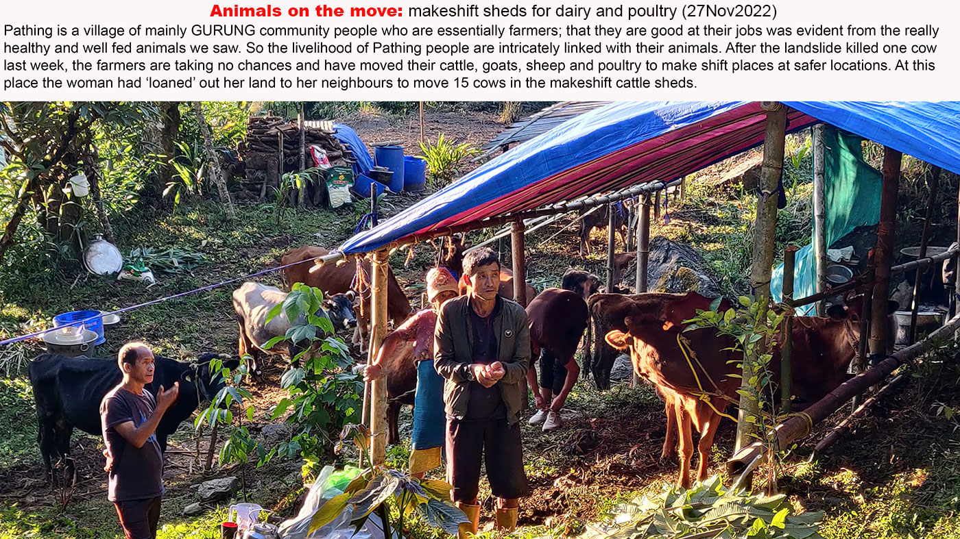
Pathing landslide in Yangyang subdivision, South Sikkim revisited: 27Nov2022
Our visit to and report on the 'Very Active Landslide', at Yangyang in South Sikkim, generated much interest from the public at large and more specifically from the people, media and government of Sikkim. As such the 7 min documentary which STH together with Junkeri Studios (Kalimpong) had almost completed required a total overhaul, since much had changed in Pathing.
The landslide, however continued to wreak havoc and we needed to update our videos as well as photos; as such we made another 3 hour trip to Pathing landslides on 27Nov2022. This photo report is from our visit there on the said date:
Probable cause of the landslide and prognosis
As per locals the landslide has been more active AFTER the monsoons rather than when it was raining. An expert whom I spoke to suggested this maybe due to
- the weak rock formations such as phyllites and schists in the mountain
- the steep (almost 60 -70 deg) incline of the slope failure
What the experts and the villagers agreed on was that it was not possible to control or mitigate this slide as such the only choice left for Pathing villagers would be to relocate to a safer place and I am glad to say that the govt is already thinking on those lines.
A glimmer of hope may also come from what the locals told me - that the frequency of rockfall was less for the last few days and that it had not been active for the 3 consecutive nights. So it could also mean that the unstable mass was collapsing slowly which may lead to this slide becoming stable over a period of time.
Location details of slide
Latitude 27° 17' 44.196" N Longitude 88° 23' 32.874" E
Elevation 1575.60 m
STH together with Junkeri Studios, Kalimpong will be coming up with a 10 min updated documentary which will include extensive drone foot-ages of the landslide, damage to the village and also interviews with affected people in the next week
As always, our thanks to all those who helped in making our second visit to Pathing possible and especially to the people of the village.
Praful Rao
Kalimpong district
Darjeeling -Sikkim Himalaya
9475033744
savethehills@gmail.com
Friday, October 2, 2020
Arubotay - a village under threat of extinction from Landslides
Till yesterday, neither I nor anyone had heard of a tiny, obscure village called ARUBOTAY (which literally translates into 'Place of Plum Trees'). It is located in Majua GP, Block Office Bijanbari of Darjeeling district and if it doesn't grow plums, what it does grow is thousands of tons of squash.
Yes! agriculture is the mainstay and livelihood of people in Arubotay - that, along with tourism.
A few days ago I received a call from a friend asking me to visit the village and check the landslide situation there. I did that with STH member Ms Shreya Gurung and Mr Christopher Lepcha of Anugyalaya, a Darjeeling based Roman Catholic NGO.
A report:
1. Location : 27.01843N 088.14789E. Elevation: 1356m
2. Brief history of the landslide
I talked to several people of Arubotay who told me that the initial cracks and fissures had appeared on the hillock during the Sikkim earthquake of 18Sep2011 but many remarked their area was stable even during the mega-disaster of Oct 1968.
Thereafter, the region had remained more or less unscathed during the many intervening years . In 2020 however, the cracks had started 'growing' as early as July following heavy rain. One must note that there is also a fast flowing mountain river (Chota Rangit) below the Sacred Heart School, on the eastern flank of the hill.
3. Landslide time and date:
The major landslide on the eastern face of the Arubotay ridge line and near the Sacred Heart School occurred at around 11.30pm on 23Sep2020, thereafter it continued on 24/25 Sep2020, when most of the instability and sinking in the village occurred. The landslide continues to be active even now.
Other data on the slide
a. Probable cause : Heavy rain and also erosion by mountain stream on the eastern flank
b. Size : Very large
c. Damage to property etc:
i. The Sacred Heart School at Arubotay is being demolished since it is unsafe.
ii. Around 26 homes totally damaged and 10 homes partially damaged
iii. Loss of farmland - around 20 acres.
iv. Road communication from Maneybhanjyang to Jorethang (Sikkim) has been cut
d. In all probability most of those who have lost their homes will have to be relocated as the mitigating or controlling the landslide appears impossible.
4. Rainfall data
The new Sacred Heart School building donated by a Luxemburg NGO was inaugurated in 2011 and was run by the Roman Catholic Diocesan trust at Arubotay. The school was functional from much earlier and had 57 students, mostly from around the area, enrolled in 2020.
The building is being DEMOLISHED today.
Update 1
On 10Oct2020, the District Magistrate, Darjeeling accompanied by the GTA Chairman (seen above), visited the ARUBOTAY landslide area and among other things discussed the possible relocation of affected people. We also know that the GSI will be send their officials for a study of the area in a few days.
Update 2 (25Oct)
Two geologists from GSI visited the area around mid Oct2020 and have filed their report to the Darjeeling district administration, based on which the BDO Pulbazar has issued a notice for relocation of the residents of Arubotay.
Our thanks to the community of Arubotay for their time and help during our visit yesterday and my sincere gratitude to Bishop Stephen Lepcha for his initiative and help.
Update 2
I received this letter from the Bishop, yesterday (16Jun2021):
SaveTheHills
Sunday, August 14, 2016
Update on Landslide Dam in North Sikkim (14Aug2016) :more images
Updates
1. No casualties so far.2. Administration has started 'miking' along some areas of NH10 which might be affected if the landslide dam bursts or overflows, this entails passing the message on vehicle borne PA systems. The important thing here is to avoid creating panic.
3. NDRF has been dispatched to the area.
4.Geologists and Disaster Management officials will survey area today.
5. Info from locals - the Kanaka river has already overflown the dam (not verified)
Praful Rao,
Kalimpong,
Dist Darjeeling