Showing posts with label dams. Show all posts

Saturday, April 11, 2026

SaveTheHills photo exhibit on 'The Teesta Valley GLOF disaster - the unheard voices' renewed till April2028 (by Social Documentary Network).

Exactly a year ago, I published a report on the Social Documentary Network (SDN) titled “Teesta Valley GLOF Disaster – The Unheard Voices.”

For those unfamiliar, SDN is a ‘global platform for documentary photographers and visual storytellers, with a strong focus on social, environmental, and human-rights issues, featuring the work of around 3,000 photographers worldwide’ (ChatGPT).

A few days ago, I was notified by SDN that the GLOF exhibit was due for renewal, which involved a fee in US dollars. However, there was also an option to apply for a fee waiver. I’m happy to share that considering our work, SDN has graciously waived the renewal fee until Apr2028.

This means our Teesta Valley GLOF exhibit will continue to remain accessible on a respected international photojournalism platform. I have also updated and refined the exhibit, and it is now available to view here.

I would urge you to take a look and share it further. The disaster remains largely unknown beyond the region, and greater awareness is essential so that the scale of the tragedy—and its continuing impact—is not forgotten.

Praful Rao,
savethehills@gmail.com
9475033744

Thursday, December 7, 2023

Side effects of the GLOF disaster - a trucker's strike in Kalimpong (04Dev2023)

One of the major impacts of the GLOF of 04Oct2023 was its effect on road communications in the lower parts of the Teesta valley that is, on NH10 which connects Gangtok to Siliguri.

About NH10

NH10 is an arterial road, vital for the nation’s security; it is the lifeline for the border state of Sikkim and for Kalimpong district in W Bengal.

Of the 114km distance between Siliguri and Gangtok approximately 92 kms of NH10 lies in mountainous terrain and for much of this distance, the highway winds itself along the banks of the Teesta river. Several large dams have now been built on the Teesta between Chungthang (Sikkim) and Coronation bridge (W Bengal) and many more are planned. The proximity of the river to the highway and the dam activity in this area has undoubtedly contributed to the instability on NH10. The 44.9km IRCON/NFR single lane railway project between Sevoke and Rangpo which has 85% of the distance in tunnels also runs close to NH10 along the valley. This is also creating problems with the excavations from the tunnels and sludge affecting traffic.

This area receives approx 2500-3000mm of rainfall annually and has a lot of landslide activity as such there are many 'hotspots' or large and troublesome landslide areas which routinely disrupt traffic during the monsoons both in the 38km Sikkim section (from Rangpo to Gangtok) and the much longer (62km) W Bengal section (Rangpo to Coronation bridge). The entire region is in earthquake zone IV.
Normally, approx 3500-4000 vehicles ply on NH10 each day from Sikkim, Kalimpong to Siliguri.

The W Bengal section of NH10 is being maintained by the PWD (W Bengal) except for a small portion between Teesta Bazar and Geil Khola which is with NHIDCL. Maintenance of the 28km part in Sikkim from Rangpo to Ranipul is again with NHIDCL
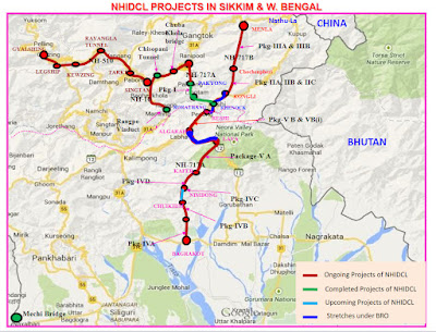
Source: NHIDCL
Current problems   
The GLOF of 04Oct2023 shredded many parts of NH10 and for some time the Kalimpong - Melli section of the highway and the Kalimpong to 27th mile sections were closed due to damage.

Drone photo of NH10 opposite Melli bazar, on 10Oct2023 which had been eroded away by the GLOF
Part of NH10 towards Sikkim from Teesta bazar after the GLOF on 10Oct2023
Part of particularly troublesome part (between Teesta bazar and Geil khola) of NH10 on 18Oct2023. 'A' is Geil Khola which was severely impacted by the GLOF and 'B' is Likhu Bhir landslide area which has been reactivated by the GLOF.

Vehicular traffic quickly resumed on the Teesta - Gangtok section of NH10 and we could report on the impact of the GLOF at Melli and Bhalukhola on 10Oct2023. The Teesta to Coronation bridge section required more time and was only opened for light vehicles (4 wheelers) and between 6am-6pm on 21Oct2023.

On 04Dec2023 truckers from Kalimpong supported by truck unions from Sikkim and also minibus operators called an indefinite strike alleging long delays in repairing the Teesta - Coronation bridge section of the highway. See map below:

* ABCF is the normal NH10 route (in the mountains) for all vehicles . Now this route is only OPEN for light vehicles. On this road, the Siliguri - Gangtok distance is 114km and takes approx 4hrs.
* Section CF is closed for 6 wheeler trucks and buses and other heavy vehicles.
* Because of the CF closure, heavy vehicles from Gangtok and Kalimpong have to detour thru ABCDEF route ie drive thru Kalimpong town, to Lava & Gorubathan which is 228km and takes approx 7 hrs
OR
* Otherwise heavy vehicles have to follow the route shown in blue (241km) ie ABDEF route which again takes 7 hours plus.
Heavy vehicular movements disrupt traffic as such they are only permitted to ply at night thru urban areas, so I met a truck driver from Sikkim enroute to Siliguri, taking a nap at 10.00am on the roadside, because he had a 7hr drive ahead in the night.
NH717A is under construction and is not available to traffic.
A smaller alternate route from Kalimpong across Relli river then thru Samthar and Panbu and Kalijhora is available for light vehicles. However, this route is not suitable for heavy traffic and is at places desolate.
Lastly, a major problem with the alternate routing thru NH717A and the current Lava - Gorubathan routing is that this area receives almost 4000mm rainfall annually, has severe thundershowers during the monsoons and has a number of large landslide zones such as that in Nimbong.
Video of heavy night time traffic thru Pedong bazar courtesy Amod Pradhan
Damaged culvert at 11th mile Kalimpong due to movement of heavy trucks from Sikkim and Kalimpong to Siliguri.

Luckily, the strike was quickly called off with the District Administration assuring the striking transporters that the Teesta - Coronation section would be opened to heavy vehicles and buses from 10Dec2023.

In all this, the plight of truckers and bus operators who have to do a grueling 7-9hr drive from Gangtok to Siliguri is understandable - it is a tough and tiring drive, mostly along mountain roads.

Freight charges of a truck from Siliguri to Kalimpong have gone up from Rs 8,000/- to roughly double that ie Rs 15,000/- and the drivers take two days to complete a round trip.

On the other hand, the caution on the part of the district administration is also very understandable. The Teesta bazar to Sevoke section of NH10 has always been a particularly vulnerable area with numerous 'hotspots' and the GLOF has only made these places weaker. Opening NH10 to full traffic in haste and without any restrictions may expose travelers along the highway to dangerous and weak areas and we have already witnessed a number of accidents along NH10 recently and even some fatalities.

Praful Rao
Kalimpong district
Darjeeling-Sikkim Himalaya
savethehills@gmail.com
9475033744

Saturday, August 15, 2015

From the Scientific American (Jul2015 issue) : 'The Impending Dam Disaster in the Himalayas'


 Two of the most populous nations—China and India—are building hundreds of dams in a violently active geologic zone
By Madhusree Mukerjee | Jul 14, 2015
 Earlier this year earthquakes in Nepal leveled thousands of buildings, killed upward of 8,500 people and injured hundreds of thousands more. The magnitude 7.8 and 7.3 temblors also cracked or damaged several hydropower projects, underscoring another imminent danger: dam bursts. More than 600 large dams have been built or are in some stage of construction or planning in the geologically active Himalayan Mountains, but many are probably not designed to withstand the worst earthquakes that could hit the region, according to a number of seismologists and civil engineers. Should any of the structures fail, reservoirs as large as lakes could empty onto downstream towns and cities. A collapse of Tehri Dam in the central Himalayas, which sits above a fault, would, for instance, release a wall of water about 200 meters high, slamming through two towns. In total, the flooding would affect six urban centers with a combined population of two million.
More powerful earthquakes are indeed likely to strike the Himalayas in coming decades, seismology models show. The Indian subcontinent is pushing under the Tibetan Plateau at roughly 1.8 meters per century, but it regularly gets stuck; when the obstruction gives way, a section of the Tibetan plate lurches a few meters southward and releases the pent-up energy in an earthquake. The Nepal earthquakes also destabilized the region to the west, notes Laurent Bollinger, a seismologist at the French Alternative Energies and Atomic Energy Commission. Destabilization makes a great earthquake, which is defined as having a magnitude of 8.0 or higher, more likely to occur sooner rather than later. Other studies indicate that the earthquakes released only a mere fraction of the stress of this fault line, which is expected to readjust with quakes of equal or higher magnitude. “Whether they'll break now, in an 8 or wait another 200 years and then give way in an 8.7, one cannot say,” says seismologist Vinod K. Gaur of the CSIR Fourth Paradigm Institute in Bangalore.
Such seismically active regions are exactly where hundreds of dams 15 meters or higher are either under construction or being planned, most of them to supply hydropower to India or China. Any dam being built during this government-funded boom, as well as those already completed, must be able to withstand the strong ground shaking of an extreme earthquake, says Martin Wieland of the International Commission on Large Dams, a group of engineers that makes recommendations for structural standards. Although every nation has its own regulations, India and China are secretive about their dam designs when it comes to public scrutiny. Independent engineers rarely are allowed to evaluate the robustness of the structures, and when they are, the results can be unsettling. For example, Probe International, a Canadian environmental research organization, reports that designers for China's Three Gorges Dam used “the most optimistic interpretation possible” of seismic shaking. Similarly Tehri Dam never underwent realistic simulations, asserts Gaur, who served on its oversight committee, along with civil engineer R. N. Iyengar, formerly of the Indian Institute of Science in Bangalore. Government-affiliated scientists and engineers claim that Tehri Dam can survive an 8.5 shock, but outside experts are not so sanguine. Any of hundreds of dams could be in danger of bursting when the next big one hits. If that were to happen during monsoon season, when the dams are full, the consequences could be catastrophic.
see also:
Local corruption can complicate matters, enabling contractors to get away with using substandard materials or deviating from mandated parameters. A 2011 study published in Nature found that an overwhelming majority of deaths from building collapse in earthquakes occur in corrupt countries.  What is more, Transparency International, a nongovernmental organization that highlights corruption, identifies public construction works as one of the world's most bribery-prone industries—with dams being of special concern. Scandals involving dam projects have roiled both India and China, to the extent that the former Chinese premier, Zhu Rongji, coined the evocative term “tofu construction” to describe a defective dike.
A handful of scientists who understand the hidden dangers of the Himalayas have taken the lead in arguing for realistic, undisguised assessments aimed at protecting the region's population, though only with limited success. In a case brought by environmentalists against Tehri Dam, the Supreme Court of India sided with government scientists to dismiss safety concerns. And in 2012 seismologist Roger Bilham of the University of Colorado Boulder was deported from the New Delhi airport, in part, he says, for his unwelcome prediction that the Himalayas can sustain a magnitude 9.0 earthquake. Bilham contends that the Indian government has since discouraged foreign collaborations in seismology.
For now, all concerned parties can do is call attention to the problem. “Sunshine is the best disinfectant,” says Peter Bosshard of International Rivers in Berkeley, Calif. “Without public scrutiny, it is much easier to get away with cutting corners.” Given the stakes, more than sunshine will be necessary: the next great earthquake in the area may well result in a man-made tsunami.
This article was originally published with the title "The Impending Dam Disaster in the Himalayan Mountains."
Original article is from Scientific American
Map of dams in the Teesta River basin is from here

Praful Rao,
Kalimpong
Dist Darjeeling