Showing posts with label Teesta river. Show all posts

Friday, July 31, 2026

Rainfall data of Jun 2026 of some towns of Sub-Himalayan W Bengal (SHWB) and Sikkim.


Progress of the monsoons (Jun2026)
Technically, the monsoons in India covers the months of June/July/August and September. News paper clips and data which highlight the progress of the monsoon in June 2026 are below:

The monsoons finally arrived over the Darjeeling-Sikkim Himalaya on 10Jun2026 and with it the IMD issued an ORANGE warning (see above) for thundershowers and rain on 10/11Jun2026.
Rainfall in June was initially deficient but picked up towards the last week of June2026:
Extreme rainfall event of 18Jun2026: covered here

IMPACTS 
The impact of the rains was mostly felt after mid-June when the rains intensified and it was mostly limited to roads and infrastructure.The impact at Mirik after the 18Jun2026 rains has already been covered.
News clips on the impact are reproduced below:

Praful Rao
SaveTheHills
savethehills@gmail.com
9475033744

Tuesday, November 4, 2025

An article by Dr R.K Bhandari - 'Where the Hills Remember, We Forget'

 Remembering the 1968 Darjeeling–Sikkim Catastrophe and the Lessons Lost in the Thin Himalayan Air

Where the Hills Remember, We Forget

The Mountain’s Enduring Reminder

Each year, the anniversary of the 1968 Darjeeling–Sikkim catastrophe reminds us of one of the most devastating multi-hazard events in the history of the Indian Himalaya. The tragedy was monumental—not only for the scale of its destruction but also for the enduring silence that followed. We must continue to remember this event, not merely to mourn its loss but to internalize the lessons it sought to teach—lessons that, if truly learned, could transform how we understand and manage our fragile mountain systems.

Disasters arrive as wake-up calls. Yet, time and again, we have slept through them. The dynamic equilibrium of the Himalaya is inextricably tied to its climate, geology, forests, water resources, and human interventions. Indiscriminate construction and unregulated development now threaten more than 45 million people living in the Himalayan region—and nearly seven times that number in the plains that depend on it (Bhandari, 1986). The future of both is inseparable.

1968: When the Himalaya Broke Loose

Between 2 and 6 October 1968, the Darjeeling–Sikkim Himalaya was battered by an extraordinary sequence of landslides, debris flows, and floods. Torrential rainfall lashed the fragile, steep, geologically young slopes—already compromised by deforestation, road cutting, and unchecked urbanization. The result was a chain reaction of slope failures and river blockages that cascaded through the region.

The worst-affected areas stretched from Kalimpong, Darjeeling, and Kurseong in West Bengal to Gangtok, Mangan, Namchi, and Rangpo in Sikkim. The Teesta, Rangit, and Rangpo Chu valleys witnessed massive slope collapses, debris accumulation, and flash floods downstream. Landslides blocked streams, altered drainage networks, and unleashed sudden bursts of water and debris. In Darjeeling alone, the Siliguri–Darjeeling Road was cut in dozens of places, paralysing transport and relief for months.

Spectacular failures marked the event—the collapse of the Anderson Bridge over the Teesta River on 4 October 1968, the destruction of critical sections of the Siliguri–Darjeeling and Siliguri–Gangtok highways, and extensive damage to tea estates, settlements, and communication infrastructure.

 The Lessons That Fade

The catastrophe of 1968 offered timeless lessons about terrain vulnerability, rainfall thresholds, the multiplier effect of connectivity loss, and the imperative of preparedness. Yet, these lessons faded into history—largely because we faltered on facts and failed to report with rigor.

When Data Deceive: Misreporting and Lost Opportunities Follow

Disasters are powerful teachers—but only if we are attentive students. Too often, we squander the opportunity to learn because we fail to decode their signatures scientifically. The value of any post-disaster learning depends entirely on the credibility and completeness of field data. Without evidence-based investigations, analysis, and contextual reporting, we lose the chance to extract actionable insight from catastrophe.

The Blind Spot: Rainfall Alone Cannot Explain It All

While the 1968 Darjeeling–Sikkim event was triggered by extreme rainfall, the fixation on rainfall alone obscured the multi-causal nature of the disaster. The region’s tectonic instability, anthropogenic disturbances, and poor slope management played equally significant roles.

The Centre for Science & Environment in Down To Earth (DTE) cited 20,000 landslides, but without clarifying the basis or criteria for this count. The figure was later echoed by ICIMOD, media outlets, and several researchers—none offering validation. Other studies cited about 7,500 landslides, also without standardized parameters. Such unverified numbers diluted the scientific understanding of the event.

The eastern Himalaya routinely records extreme rainfall events—ranging between 300 mm/day and 1,100 mm/day. In the 1980s, Sikkim’s annual rainfall reached 3,000–5,000 mm, with 50–90 % falling in just four months. Rainfall, river action, seismicity, deforestation, and blasting together amplify slope instability (Bhandari, 1988).

In 1968, a deep Bay of Bengal depression interacting with monsoon currents trapped along the Himalayan foothills caused nearly 100 hours of continuous rainfall. The IMD recorded 499 mm in one day and over 1,000 mm in 52 hours, while DTE and GSI reported totals of 1,000–1,040 mm for 3–5 October. For comparison, Padamchen in East Sikkim once recorded 1,580 mm in 36 hours (Chandra, 1973).

If a single catastrophic landslide demands detailed mapping, analysis, and remediation, how would we manage 20,000 such failures simultaneously? Many were likely inter-connected—progressive or retrogressive systems rather than isolated slides. Without classifying landslides by type, size, mechanism, and cause, no meaningful investigation or mitigation strategy is possible.

 Credible Loss Assessment: The Basis for Response

According to Down To Earth, approximately 20,000 people were killed, injured, or displaced—a figure often misinterpreted as fatalities alone. Some secondary sources vaguely reported “thousands killed,” while no authenticated death toll exists even today. What is certain is that damage was widespread and intense, devastating tea gardens, settlements, and market areas such as Rangpo, which lay buried under two metres of debris.

DTE also reported 92 road cuts, multiple bridge collapses (including the Anderson Bridge), and weeks-long railway closures. The GSI corroborated extensive breaches along the Siliguri–Darjeeling highway and major failures in the Teesta valley. Estimates suggest 10,000 homes partially or fully damaged, hundreds of bridges destroyed, and large sections of NH 31A washed away. Rivers like the Teesta and Rangit changed course in several places.

The confusion in reporting—some data referring to Darjeeling town, others to the district or to Sikkim—underscored a critical gap: credible, area-specific loss reporting is essential for a measured post-disaster response. Without clarity, policy and recovery both flounder.

A Clarion Call for Scientific Slope Engineering

The 1968 catastrophe was a clarion call for scientific landslide investigation and engineered slope management. Roads in Sikkim and North Bengal traverse elevations from 120 m to over 4,300 m, cutting across unstable ridges and deeply dissected valleys. Slopes vary from forested to barren, shaping complex hydrogeological responses. When roads are built without protecting natural drainage or stabilizing slopes, the mountains retaliate.

At the International Symposium on Landslides (New Delhi, 1980), Gen. J.S. Soin, then Director General of Border Roads, recounted the catastrophic slides of 1889, 1900, 1906, 1911, 1914, 1958, 1968, and 1973. He described a 1-km road section in 1968 completely destroyed—retaining walls gone, new alignments carved, drainage and river-training works repeatedly rebuilt after successive floods. Such cases illustrate that ad-hoc repairs are no substitute for science-based, environmentally consonant engineering.

More than five decades later, that lesson remains painfully relevant. The scars of both dormant and active slides demand ongoing investigation. Each reactivation is a reminder that the Himalaya remembers—even when we choose to forget.

Global Reflections on India’s 1968 Reporting

Dr R.L. Schuster of the United States Geological Survey once asked me to verify data on the 1968 catastrophe. Lacking credible evidence, he doubted reports of 20,000 landslides and 20,000 casualties. A UNESCO publication (Moscow, 1988) later cited Mathur (1982), estimating restoration costs at $14 million for North Bengal and $8 million for Sikkim. Even globally, the 1968 event stands as a cautionary tale—less for its magnitude than for the uncertainties that clouded its record.

The Way Forward: Learning Before Forgetting

The 1968 Darjeeling–Sikkim event reaffirmed that the future of landslide risk management must rest on E A R T H—Ethics, Accountability, Resilience, Technology, and Humanity.

For decades, the management of landslides and the mitigation of their societal impacts have run on parallel tracks, intersecting only at conferences or in official declarations. The time has come to walk the talk—to embed every lesson from every disaster into planning, design, and governance.

Ethical responsibility and societal well-being must sit at the heart of our disaster-mitigation agenda. Bridging the divide between scientific insight and public policy is no longer optional—it is the only path forward.

References

Bhandari, R.K. (1977) : Some Typical Landslides in the Himalaya. Proc. 2nd Int. Symp. on Landslides, Japan Society of Landslides, Tokyo, pp. 1–33.

1.      Bhandari, R.K. (1981) : Landslides in the Himalaya—Problems, Causes and Cures. UNESCO Project “Protection of Lithosphere as a Component of Environment,” Alma-Ata, USSR.

2.      Bhandari, R.K. (1986) : Slope Stability in the Fragile Himalaya and Strategy for Development. IGS Annual Lecture.

3.      Chandra, H. (1973) : Problems of Highway Engineers in the Himalayas. Journal of the Indian Roads Congress, 35(2), p. 363.

4.      Down To Earth (2023). Darjeeling and Sikkim: 1968’s Forgotten Deluge. Centre for Science and Environment.

5.      Telegraph India (1968). Darjeeling–Sikkim Devastation Déjà Vu: Autumnal Cloudburst Triggers Hill Horror.

6.      Geological Survey of India (1969). Report on the Landslides and Floods in the Darjeeling–Sikkim Himalaya.

7.      Indian Meteorological Department (1968). Climatological Report on the October 1968 Rainfall in Eastern Himalaya.

8.      Inventory and GIS Mapping of Landslides in Sikkim (ssdma.nic.in).

9.      Mathur, H.N. (1981) : Influence of Human Activities on Landslides. UNESCO Publication, Alma-Ata, USSR.

10.  Natarajan, T.K., R.K. Bhandari et al. (1980) : Some Case Records of Landslides in Sikkim. Proc. Int. Symp. on Landslides, Vol. 1, pp. 455–460.

11.  Starkel, L. (1972). The Role of Catastrophic Rainfall in the Shaping of the Darjeeling Himalaya. Geographia Polonica.

12.  Basu, S.R., & Sarkar, A.K. (1981). Landslides and Morpho dynamic Evolution in the Darjeeling Himalaya.

13.  Soin, J.S. (1980) : Landslide Problems on Roads in Sikkim and North Bengal and Measures Adopted to Control Them. Proc. Int. Symp. on Landslides, Vol. 1, pp. 69–78.

14.  Wikipedia. 1968 Sikkim Floods – Details of Rainfall, Fatalities, and Landslides.


My grateful thanks to Dr R.K Bhandari, whom I have known for many years now

Dr R.K Bhandari, is long acknowledged to be one of the foremost authorities on landslides in the world. He is the recipient of numerous, well deserved awards including the prestigious Subash Chandra Bose Aapda Prabandhan Puraskar in 2021.
He is a member of HA.

Praful Rao,
savethehills@gmail.com
9475033744


Tuesday, October 28, 2025

Extreme rainfall event in Kalimpong district: 04/05Oct2025 ('Impact on Teesta Bazar')


The first photographic records of major flooding at Teesta Bazar is of the October 1968 disaster when extensive portions of the settlement were washed away by the Teesta River. The event also led to the collapse of the Andersen Bridge — a key river crossing at Teesta Bazar — reportedly as a result of the sudden failure of a landslide-dammed lake located further upstream.
Subsequent decades saw recurring flood impacts in the area. In October 2023, Teesta Bazar was severely affected by a Glacial Lake Outburst Flood (GLOF) originating from the upper Teesta basin. This event caused extensive damage along the Teesta valley and was documented in detail by SaveTheHills (STH).
In July 2024, the locality again experienced significant flooding. Despite detailed recommendations submitted by STH regarding necessary mitigation and risk-reduction measures following the 2023 event, most corrective actions remained unimplemented. Consequently, the warning issued in the 2024 report — “Failure to take timely corrective action will mean a repetition of this whole scenario once again in 2025” — was validated when a similar flood event reoccurred in October 2025.
This pattern underscores the urgent need for comprehensive and coordinated flood mitigation interventions at Teesta Bazar, including structural and non-structural measures, to prevent further recurrence of such disasters in the future.
As expected the town again experienced major floods during the deluge of 04/05/Oct2025. STH photographer Praveen Chhetri was available at site to record the event:
Submerged Darjeeling - Kalimpong road: Two women from Teesta bazar wistfully look at the flooded Kalimpong-Darjeeling road on 05Oct2025. 
I took the photo (below) from almost the same spot on the Teesta bridge in 2024 when the river had receded and the submerged homes alongside the road were visible.
This road passes thru Teesta bazar and every time it is flooded, we have to take a lengthy 6hr detour instead of the normal 2hrs to/from Darjeeling.
Drone image of the flooded Darjeeling-Kalimpong road at Teesta bazar on 05Oct2025
On 05Oct2025, the Teesta submerged this junction of NH10 and the road to/from Darjeeling (where motorcyclists have assembled). In the distant, the Teesta bridge linking Gangtok and Kalimpong is visible - the river is huge and stretches from one bank to the other.
Trees, stumps and debris were again dumped on the Darjeeling-Kalimpong road below the Teesta bridge by the floods of 05Oct2025.
Almost an annual event - flooded homes in Teesta bazar on 05Oct2025.
The Teesta flowing bank to bank on 05Oct2025. NH10 which connects Siliguri to Gangtok is blocked at Rabi Jhora which is a small flooded bridge on the right bank. This extreme event took place at the peak of festivities and Puja season with hundreds of vehicles choking the highways and roads. 
All photos (except one taken in 2024) by Praveen Chhetri @ Junkeri Studios, Kalimpong. My grateful thanks to Praveen (junkeristudio@gmail.com) for photographing the event as a historical record. 

Praful Rao
SaveTheHills
savethehills@gmail.com
9475033744

Thursday, December 19, 2024

A post GLOF look at the Teesta bazar and its vicinity (Part -1)

A few days ago, a friend called from Mangan, the headquarters of North Sikkim district, eager to witness the aftermath of the Teesta Valley Glacial Lake Outburst Flood (GLOF) that occurred on October 4, 2023. She expressed difficulty in identifying the affected areas. I empathized, recalling how we began documenting the disaster through photographs and recordings on the very day it happened.

Over a year has passed, including a full monsoon season. During this time, nature has altered the landscape, roads and homes have been repaired, and damaged machinery and assets have been removed or replaced. These changes underscore the importance of promptly documenting disasters, at least through photography, to capture the immediate impact before recovery efforts and natural processes transform the scene.

The Glacial Lake Outburst Flood (GLOF) on October 4, 2023, caused the Teesta River's level to surge by approximately 3 to 4 meters throughout the valley. This event deposited substantial silt and debris along the river's course. While monsoon floods have since washed away some of these deposits, the river is gradually reestablishing its natural channel—a process that can span several years. Consequently, we must brace for potential challenges during upcoming monsoon seasons. The current dry season offers an ideal window for implementing necessary preparations; however, I have observed a concerning lack of such proactive measures and towards this end we have voiced our concern by writing to the highest levels in the country.

With regard to the disaster, I made a visit on 18Dec2024 to the Teesta bazar and its vicinity to check and photograph the area. My report:

a. River Condition:
The Teesta River has shed much of the silt and debris left by the October 2023 GLOF and is regaining its characteristic emerald-green winter hue. In some areas, the river has carved out a defined channel, reducing its erratic flow over the 3-4 meter thick debris layer deposited during the disaster.

b. Disaster Mitigation Efforts:
No visible disaster mitigation efforts were underway in Teesta Bazar or its surrounding areas. Residents I spoke to expressed deep frustration over the lack of action.

c. Local Economy - Rafting Resumes:
Rafting activities have resumed in the Teesta/Labar Boatay area, providing direct and indirect employment to approximately 2,000 people.

d. Tribeni Covid Hospital:
A footpath to the Tribeni Covid Hospital is functional. However, much of the hospital's infrastructure has been either looted or washed away by the floods, leaving it in a dire state.

e. NH10 Road Conditions:
On the short stretch of NH10 I traveled, significant repair work was underway near Likhu Bhir. However, areas around the 29th mile and Melli remain vulnerable, with visible cracks and sinking sections near the riverbank. These areas are at serious risk of collapse during the next heavy rains.
Placed below are images of the area:


Documentation of parts of the above report was supported by Royal Enfield, as part of their Social Mission Initiative


Praful Rao
SaveTheHills
savethehills@gmail.com
9475033744

Monday, October 7, 2024

Rainfall data of Sep 2024 of some towns in Sub-Himalayan W Bengal and Sikkim

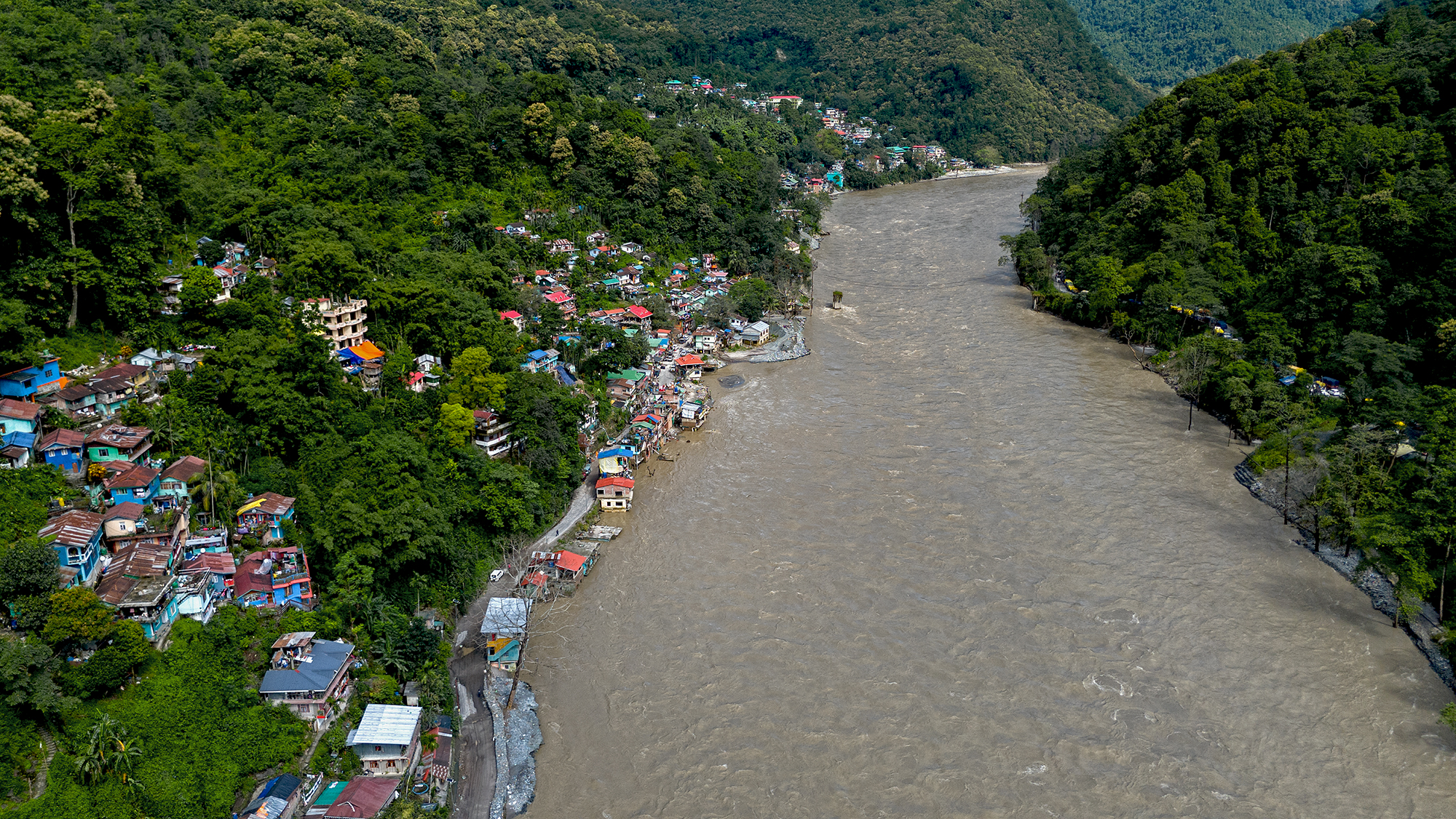
Teesta river and bazar on 29Sep2024, a few days after heavy rain on 27/28Sep. The river had receded quite a bit yet it flowed nudging the bazar and the Darjeeling road at many places. The river is still swift and flows from one bank to the other.
Notice the way the heavy rain is all stacked up in the last week of the month with the first few weeks being deficient in rain.
A dramatic shift from deficient rain upto 25Sept followed by a large surplus thereafter.


The impact of the heavy rains in the month end has already been covered in a separate post here


Praful Rao
SaveTheHills
9475033744
savethehills@gmail.com

Thursday, September 5, 2024

Survey of parts of the Teesta Valley (Part I) in Sep2024 - Impact of a landslide on 20Aug2024 at NHPC Stage V Power Station complex at Baluatar (Singtam)-Sikkim.

NHPC has a large residential/administrative complex at Baluatar (Singtam), SIkkim (27 15 1.8 N  88 27 34.1 E) parts of which were severely damaged by the 04Oct 2023 GLOF. We have done an extensive photo report of the area here
The area also houses the power station complex of the NHPC (510MW) Stage V (Dikchu) dam which was also severely damaged by the GLOF and which we have covered in our report here
On 20Aug2024, a major landslide occurred approximately below Dipu Dara, a small hamlet on the Singtam-Dikchu road which damaged the GIS building of the power station:
Report from 'The Telegraph' on the landslide and our update.
The GIS building of the Dikchu (Stage V) power house which was severely damaged by the landslide on 20Aug2024 (photo dated 19Nov2023). The landslide occurred from behind the white building.
This technical complex adjacent the GIS building was totally buried by the landslide on 20Aug2024 (photo dated 19Nov2023).
Dipu Dara village and the landslide at the power station. Dipu Dara residents recollect hearing a loud rumble at around 7.30am on 20Aug2024.
The damaged GIS building and buried adjacent technical structures. The bridge at the extreme right hand, lower corner has been newly constructed after the old one was washed away last year (see below)
NHPC bridge across Teesta river which was destroyed in 04Oct2023 GLOF (photo dated 19Nov2023).
Close up view of the landslide and Dipu Dara. There are 5 homes in the vicinity of the landslide crown which had been evacuated and the Dikchu - Singtam road seen here was closed for 6 days. Locals say the area was a sinking zone and some blame NHPC tunnels but the fact is that rainfall was not a trigger for this landslide.
View of the landslide and parts of the NHPC complex at Baluatar (Singtam), Sikkim which lie across the Teesta river. During and soon after the landslide on 20Aug, there were rumors that the landslide had dammed the river but the width of the valley here is huge as can be seen in this photo.
The Dikchu-Singtam road at Dipu Dara (27 15 8.0 N  88 27 38.7 E, elevation 577.2m). This section of the road was closed for 6 days after 20Aug204 and the traffic diverted thru an alternate route. The landslide took place directly below this place which some locals say was always a sinking area.

Documentation of the above report supported by Royal Enfield, as part of their Social Mission Initiative


Praful Rao
SaveTheHills
savethehills@gmail.com
9475033744


Monday, August 12, 2024

Rainfall data of July 2024 of some towns in Sub-Himalayan W Bengal and Sikkim

IMPACT OF THE JULY 2024 RAINS AT TEESTA BAZAR:
Some young men at Teesta bazar had started a two wheeler repair business in this shop on the Darjeeling-Kalimpong road after they shovelled out all the sand and debris brought in by the 04Oct2023 disaster (notice the damaged ceiling fans). The rains of July2024 put an end to their business venture and dreams when the Teesta river, flowing in the vicinity and almost at the same level flooded their shop again during heavy rains.


Rainfall normally peaks in July during the monsoons after which the rainfall gradually declines in August and Sept with the monsoons normally exiting our region in October.
As is clearly visible from the top data, rainfall was heavier in the Dooars area and foothills of Kalimpong district (and Bhutan hills).
IMPACT
The amount and intensity of rainfall impacted road communication a lot with NH10 and the Darjeeling - Kalimpong road being closed OFF and ON thru the month.
Even Rohini road to Darjeeling from Siliguri was closed for some time on 02Jul2024

                                Landslide near Loreto School, Darjeeling - 05July2024

INFACT NH10, WHICH HAD CLOSED ON 01JULY2024, COULD NOT BE RE-OPENED FOR TRAFFIC UNTIL 31JULY2024 - WHICH WAS THE LONGEST DURATION THAT THE HIGHWAY WAS CLOSED CONTINUOUSLY EVER - ALL DUE TO THE TEESTA VALLEY GLOF OF 04OCT2023.
Landslide on NH10, at Andheri, near Rangpo on 16July2024.
A low pressure area in the Bay of Bengal which brought in a drier spell of weather in our region after the heavy rains in the first half of July2024.
My thanks to all our What's App group ('Hazard Alerts') members whose images and stories I have used in this post

Praful Rao
with
Yukta Acharya

SaveTheHills
Kalimpong district
Darjeeling-Sikkim Himalaya
savethehills@gmail.com
9475033744