Showing posts with label darjeeling sikkim Himalaya. Show all posts

Friday, July 31, 2026

Rainfall data of Jun 2026 of some towns of Sub-Himalayan W Bengal (SHWB) and Sikkim.


Progress of the monsoons (Jun2026)
Technically, the monsoons in India covers the months of June/July/August and September. News paper clips and data which highlight the progress of the monsoon in June 2026 are below:

The monsoons finally arrived over the Darjeeling-Sikkim Himalaya on 10Jun2026 and with it the IMD issued an ORANGE warning (see above) for thundershowers and rain on 10/11Jun2026.
Rainfall in June was initially deficient but picked up towards the last week of June2026:
Extreme rainfall event of 18Jun2026: covered here

IMPACTS 
The impact of the rains was mostly felt after mid-June when the rains intensified and it was mostly limited to roads and infrastructure.The impact at Mirik after the 18Jun2026 rains has already been covered.
News clips on the impact are reproduced below:

Praful Rao
SaveTheHills
savethehills@gmail.com
9475033744

Thursday, June 4, 2026

Rainfall data of May 2026 of some towns of Sub-Himalayan W Bengal (SHWB) and Sikkim.

May marks the final month of the pre-monsoon season and normally receives 257.5 mm rainfall over the Sub-Himalayan West Bengal (SHWB) and Sikkim region according to IMD (1971–2000 normals). The month is usually characterized by thunderstorms, squalls, hailstorms, and increasing moisture influx from the Bay of Bengal ahead of the southwest monsoon.


May 2026 was a highly variable month, with rainfall distributed unevenly across the region. Some locations experienced rainfall well above the long-term normal, while others remained comparatively dry.

A notable feature was the occurrence of several intense rainfall events between 13–17 May and again around 22–26 May, particularly affecting Sikkim and parts of the Himalayan foothills.
The extraordinary rainfall which took place in Kalimpong on 28May2026 is covered in an earlier blog.

 Wettest Stations
  1. Mangan – 642.3 mm
  2. Gangtok – 584.5 mm
  3. Sevoke – 440.4 mm
  4. Kurseong – 434.2 mm
Driest Stations
  1. Khanitar – 92.4 mm
  2. Darjeeling – 131.2 mm
  3. Kalimpong – 213.0 mm 
Above and Below normals
The IMD normal rainfall for May over SHWB & Sikkim is 257.5 mm. 

Above Normal

Mangan (+149%)
Gangtok (+127%)
Sevoke (+71%)
Kurseong (+69%)
Banarhat (+43%)
Alipurduar (+43%)
Siliguri (+30%)
Damthang (+18%) 

Near Normal 
Neora (−8%) 

Below Normal 
Kalimpong (−17%)
Darjeeling (−49%)
Khanitar (−64%)

Spatial Distribution

Northern Sikkim (see map - Zone 1)

Mangan and Gangtok experienced exceptional rainfall. 

Foothills and the Dooars (see map - Zone 2)

Sevoke, Banarhat, Alipurduar and Siliguri all received abundant rainfall. The foothill belt was particularly active during thunderstorm episodes.

Darjeeling/Kalimpong Hills (see map - Zone 3)

Darjeeling itself was surprisingly dry compared with neighbouring Kurseong and Kalimpong. This highlights the highly localized nature of pre-monsoon convection and terrain-induced rainfall.

Praful Rao
SaveTheHills
savethehills@gmail.com
9475033744

Sunday, April 14, 2024

Our adverse weather early warning work on What'sApp groups in the Darjeeling- SIkkim region: Thunderstorms of 11/12Apr2024 in Kalimpong

After the Teesta Valley GLOF of 04Oct2023, our region has been extraordinarily dry, with the erratic western disturbance activity in the winter months, robbing us of all our winter rain. In Kalimpong we had the first showers after Oct2023, between 19 & 27Mar2024 where we clocked 112.6mm. Thereafter, it has been dry with forest fires again starting in the Teesta Valley.
With regard to early warnings on adverse weather events and disbursement of information on landslides, road blocks etc, SaveTheHills has been running several very active and large What'sApp groups in the Darjeeling-Sikkim region called 'Hazard Alerts or HA' for many years now and the following cloud image on approaching adverse weather was posted in the group on 11Apr2024:

This image was posted on 'Hazard Alerts' WhatsApp group at 1.31pm on 11Apr2024 along with lightning warnings from the IMD 'Damini' (lightning warning) app. Shortly after this was done, the first storm hit our region at around 2.30pm. Wind speeds in gusts reached upto 58kmph.


This storm died down momentarily at around 4.30pm only to pick up again quickly. The following cloud image along with NOWCASTs from IMD were posted to members in the 'Hazard Alerts' What'sApp groups.
Warning posted at 5.36pm to our WhatsApp groups alerting them about another storm which was approaching.
Subsequent cloud images which show the progress of the storm from 6.45pm to 10.45pm on 11April2024


The thunderstorm which hit Kalimpong at 2.30pm on 11April2024, raged right thru the night and only ceased at around 8.00am on 12Apil2024. Surprisingly, we had only 2mm of rain however strong, gusty, westerly winds from Nepal along with lightning prevailed for more than 12hrs. The graphical analysis of the windspeed from our Davis Vantage Pro AWS is placed below:

Though there were no casualties or damage from the storm, what was unusual was its duration considering there was no major weather system (such as a depression/cyclone) near by.
Also what is possible today is to get reliable and accurate information of such weather events in advance and to disburse the same quickly to a large number of people. We have been doing this regularly in WhatsApp since Jun 2016.

Praful Rao
Kalimpong district
Darjeeling-Sikkim Himalaya


Saturday, March 23, 2024

After the drought - welcome rains in mid - March2024 but also the adverse impact on NH10

After the devastating Teesta valley GLOF of 04Oct2023, our region went in for a four and a half month drought where we did not get a drop of rain:

Both the post-monsoon and  winter season rains went missing and with the vegetation and forests bone dry, we had forest fires much earlier than usual (SHWB is Sub-Himalayan W Bengal)
Screenshot of my post in our What'sApp group, 'Hazard Alerts' showing forest fires in Jan2024.
Forest fire in Sikkim: 16Mar2024


The drought-like conditions continued right upto mid-March2024 with acute drinking water scarcity in many of the urban centres in our region - in Kalimpong there was a 3 day waiting list for anyone wanting to buy water from the water tankers and also, I believe people have started drilling for ground water again. In the rural areas, springs dried up.

Winter rains are caused by Western Disturbances (WDs) which originate around the Mediterranean sea.
DownToEarth
reported on the matter, excerpts of which are placed below:
'There has been a lack of rainfall during the post-monsoon season and next to no winter snowfall in some of the north Indian states as a result of a lack of intense western disturbances. This can affect the yield of Rabi crops in these regions and also availability of water in the mountains in general. The lack of snowfall in the mountains could also lead to a warmer than normal pre-monsoon season, with excess rainfall that could affect the harvesting period of Rabi crops. 
Winter precipitation in north India is essential to ensure people’s food and water security. While Rabi is the major cropping season encouraged by rainfall, the glacial streams and rivulets in the Himalayas are fed by melting snow and ice later in the season. 
The only source of rainfall and snowfall in the region are extratropical storms known as western disturbances (WD), which travel from the Mediterranean region. They induce cyclonic circulations in the lower layers of the atmosphere, which cause rainfall in the plains and snowfall in the mountains. They also interact with other wind systems such as the easterlies (winds blowing from the east) to cause rainfall in central India.
The WDs have been showing a decline in intensity in the past few years due to changing climate. The trend continued in the post-monsoon and winter seasons of 2023 as well.
From October 1, 2023 to January 2, 2024, 16 WDs have affected India — five in October, five in November and six in December — out of which only three have been intense and caused rainfall, according to data from the India Meteorological Department (IMD), analysed by Down To Earth (DTE).
This has caused rainfall deficits in states like Uttarakhand and Himachal Pradesh. While Uttarakhand experienced 47 per cent less rains than normal from October 1 to December 27, the deficit in Himachal Pradesh was 40 per cent, according to data from IMD.
Eight out of the 13 districts of Uttarakhand had deficient rainfall (20-59 per cent less rainfall than normal) and four of them suffered from large deficient (greater than 60 per cent deficit) rainfall. Udham Singh Nagar district had the maximum deficit of 87 per cent. 
In Himachal Pradesh, four districts had deficient rainfall and two had large deficient rainfall. Lahaul and Spiti district had the maximum deficit of 73 per cent.
“Himachal Pradesh and Uttarakhand received deficient precipitation since western disturbances during the post-monsoon were weak in nature,” Akshay Deoras, a research scientist at the National Centre for Atmospheric Science and Department of Meteorology, University of Reading, United Kingdom, told DTE.
“The western disturbance activity witnessed a southward dip in December, causing good rainfall over central India, but either deficient or scanty rainfall over most of northern India in December,” he added. 
Towards the end of November, a moderately intense WD interacted with a lower level trough in the easterlies and chased significant rainfall in central and western Indian states of Gujarat, Maharashtra and Rajasthan.
“The northwest rainfall reduction is consistent with the general decreasing trend in western disturbances and the precipitation drop over the region. But the El Nino also tends to produce colder winters over parts of this region,” Raghu Murtugudde, a climate scientist at the University of Maryland and Indian Institute of Technology Bombay, told DTE.
Murtugudde predicted that the pre-monsoon season will be warmer and probably get more rainfall because of the Arabian Sea warming. “If the summer transitions to a La NiƱa then we should have excess rainfall during the monsoon season,” he concluded.

The drought mercifully ended on 20March2024 in Kalimpong and also the rest of
.Sub - Himalayan WB and SIkkim with thundershowers commencing at 2.30am.
The weather systems which affected us and the cloud image is shown below:

For the past few days we have had welcome light rain in our region. Rainfall totals from 20-22Mar2024 are given below:
Darjeeling 118.6mm  Kalimpong  67.2mm  Bagdogra  92.1mm  Gangtok 46.2mm

NH10 status
We have reported extensively on the impact of the GLOF on roads and bridges in our earlier blogs including one exclusively on the part of NH10 which is now causing massive traffic jams here.
What is alarming is that after absolutely no rain for months, the first light/moderate rainfall can disrupt our communication lines so much - an issue which was pointed out by us in the report submitted to the NDMA & SDMAs of W Bengal and Sikkim on 10Nov2023.
Excerpt of the report is below

I shudder to think what will be the condition and status of NH10 when the SW monsoons set in a few months time.

Traffic jams today at Chitrey (top) and Teesta bazar on NH10
Landslide at Likhu Bhir (NH10) on 21Mar2024
(Images from Hazard Alerts What'sApp group - many thanks:)


NH10 and alternate routes in the Kalimpong- Sikkim area
Kalimpong District Administration's What'sApp message on 21Mar2024 advising alternate routes

Praful Rao
Kalimpong district
Darjeeling-Sikim Himalaya
savethehills@gmail.com
9475033744


Saturday, August 26, 2023

Extraordinary rains on 24/25Aug2023 in the Darjeeling - Sikkim Himalaya

 Meteorological conditions

Satellite images
Early Warning
We had an 'Orange Alert' for heavy rain in our region

which was upgraded to a 'Red Warning' on 25Aug2023.

Rainfall data


Landslides and other images


Media Report

Excerpt from the Millenium Post (25Aug2023)
Amitava Banerjee

Darjeeling: Incessant rain triggered landslides in the Hills claiming the life of a 59-year-old in Darjeeling. A three-and-a-half-year-old also lost his life in a landslide in Sikkim. Numerous landslides occurred in Darjeeling owing to the continuous heavy rainfall. The Indian Meteorological Department (IMD) has issued a “Red” alert for Saturday followed by a “Yellow” on Sunday. The rise in the water level of River Teesta in the Kalimpong district has emerged as a major cause of concern. 15 families have been shifted from the vulnerable areas- banks of the River Teesta. “59-year-old Baburam Rai died in a landslide in Puttabong tea estate under the Rangit-1 Gram Panchayat, Bijanbari block, Darjeeling,” stated S Ponnambalam, District Magistrate, Darjeeling.

A landslide occurred at around 7 am in the Guest House area of Puttabong on Friday. The houses of Baburam Rai and Uttam Rai were totally damaged in the slide. Baburam was also buried below the debris. Fire brigade, police and local residents later managed to recover his body. A landslide occurred at Bangladanra in Rungbul on the National Highway 55 to Siliguri at around 9 am. Two huge uprooted trees blocked the National Highway, bringing traffic to a standstill. The trees were removed and debris cleared with traffic resuming around 11 am. Rimbik was cut off for a while with both the roads connecting Rimbik blocked by landslides. A slide occurred at Khopeydanra at around 6 am cutting off Rimbik from Maneybhanjyang. The road connecting to 3rd Mile was also blocked owing to an uprooted tree. Work was on to clear the road.

One shop belonging to Jayram was totally damaged along with around 11 houses partially damaged owing to a landslide in Gudamdhura, in Tamansang under Sukhiapokhari, Jorebungalow. Sandeep Chhetri, GTA Sabhasad of Marybong Tamsang had a narrow escape when his vehicle turned turtle while on a visit to landslide affected areas near Lingia Tea Estate Factory. The Sabhasad suffered minor bruises while his driver also escaped unhurt. The IMD issuing a “Red” rainfall warning has forecasted heavy to very heavy rainfall (7-20cm) at one or two places coupled with thunderstorms and lightning in the districts of Darjeeling, Kalimpong and Jalpaiguri on Saturday.

My thanks to members of 'Hazard Alerts' our Whats App group for the information on landslides.

 Praful Rao
Kalimpong district
Darjeeling-Sikkim Himalaya
savethehills@gmail.com
9475033744

Thursday, October 6, 2022

Rainfall data of Sep 2022 of some town in the Darjeeling - Sikkim Himalaya


We had deficient rainfall again for most towns with the notable exception of Mangan in N Sikkim.
Kalimpong was the most deficient receiving only 35% of its monthly rainfall. Interestingly, much of Kalimpong district is bang opposite SOUTH SIKKIM district and is separated only by the Teesta river. South Sikkim is the drought prone district of Sikkim ( -21% deficiency) as such rainfall deficiency in Kalimpong may be expected.
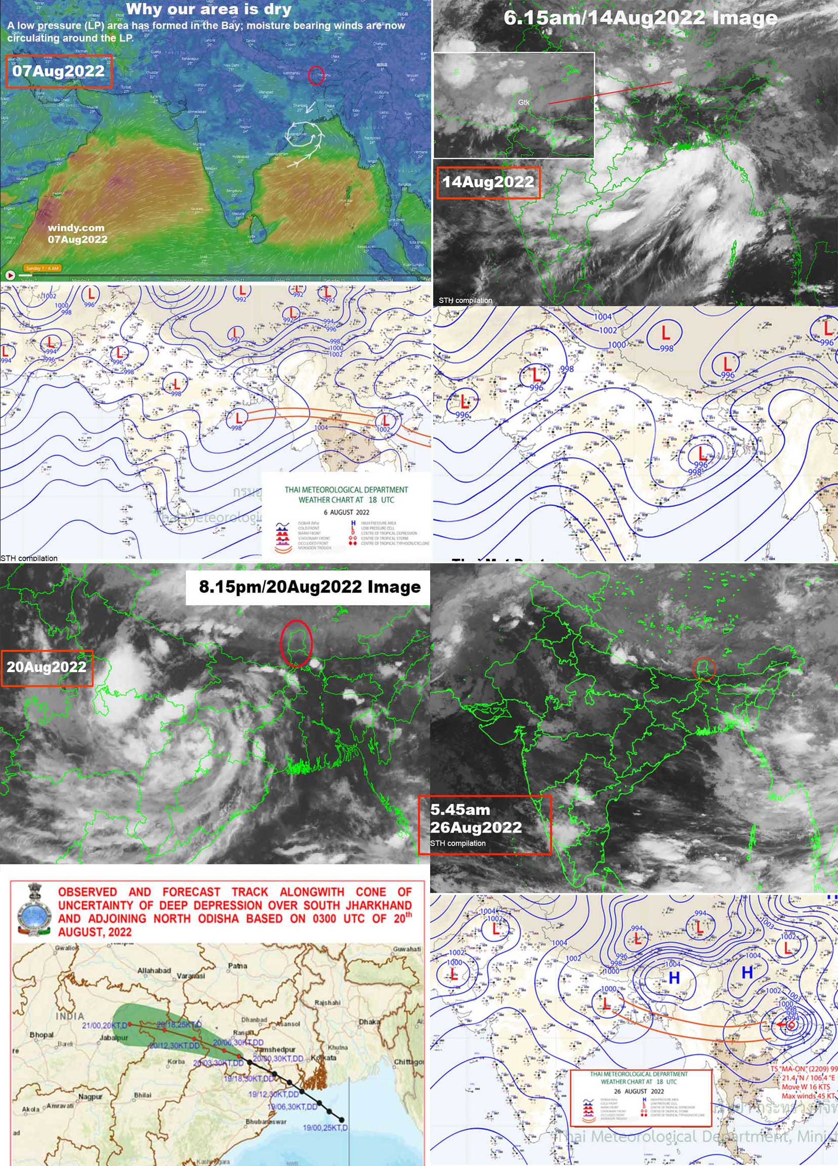
A number of low pressure areas formed in the Bay of Bengal during Sep2022 and that could be the reason for less rain in our region (the moisture bearing winds are drawn away from the sub - Himalayas when a circulation forms in the Bay).

Update from 'The Weather Channel' on 11Oct2022
Meanwhile, the southwest monsoon continues to withdraw from the northwestern parts of the country. Normally, its exit from the northeastern region begins around October 10; but judging from the rate of withdrawal thus far, it may get slightly delayed this year.

As for the seasonal precipitation, the northeastern region collectively recorded below-average rainfall during the four monsoon months from June to September. The combined monsoon rain figure for East and Northeast India stands at 1124.8 mm — 18% below their long-period monsoon average of 1367.3 mm.

Within the Northeast, the Assam-Meghalaya subdivision recorded 1600.7 mm rain (9% deficit), the N.M.M.T. states registered 943.2 mm precipitation (28% deficit), Arunachal Pradesh received 1430.3 mm (15% deficit), while Sub-Himalayan West Bengal and Sikkim enjoyed precisely ‘normal’ seasonal rains at 1887.1 mm.

Praful Rao
Kalimpong district
Darjeeling Sikkim Himalaya

Saturday, September 3, 2022

Rainfall data of August 2022 of some town in the Darjeeling - Sikkim Himalaya


August 2022  was again a month when rainfall for most places, in the Darjeeling Sikkim Himalayas was less than normal - with most of the precipitation taking place in the plains of the Dooars in Jalpaiguri and Cooch Behar districts.
Also for the second successive month, Darjeeling had less rain than Kalimpong.

What undoubtedly caused less rainfall was sudden activity in the Bay of Bengal with several low pressure areas forming which then moved inland as depressions.


The rainfall distribution in Sikkim and North Bengal (as per IMD) is shown below. The hills of Darjeeling and Kalimpong districts along with East and South Sikkim districts saw deficient rainfall.
Not much landslide activity was observed in our region, the exception being several areas along NH10 (Highway connecting Siliguri to Gangtok).

As you would observe we have added several remote areas, in our rainfall reports - these area Mangzing and Bijanbari.
Mangzing (in Gorubathan block, Kalimpong district) receives the full fury of the monsoons and has the around the highest rainfall in our region.


Praful Rao,
Kalimpong district
Darjeeling - Sikkim Himalaya