Showing posts with label climate change. Show all posts

Wednesday, May 20, 2026

Using the Automatic Weather Station data to understand weather and rainfall (in this case, of Kalimpong)

The rainfall chart for the period May2025 to May2026 for Kalimpong is above and a brief analysis of the same here👇:
a. We had a fairly wet monsoon season (from approx May to Oct2025) characterized by 9 spikes when rainfall exceeded 90mm in a 24hr period. The season did start with some hiccups though:
Typical cloud image over North Bengal and Sikkim before the heavy rain of 19Jun2025
Warning on 13Jul2025 for the heavy rain (112.8mm) on 14Jul2025.

July is typically the wettest month of the monsoon season. In July 2025, there were four days during which rainfall exceeded 90 mm in a 24-hour period. Thereafter, rainfall gradually declined, apart from a brief spike on 12 August 2025. Total rainfall amounted to 467 mm in August and 253.2 mm in September 2025.

October 2025 was relatively dry, except for two days of intense rainfall. On 4–5 October, widespread heavy rain affected the entire region and triggered devastating landslides and flash floods, resulting in significant loss of life in Mirik.

These instances of spikes in rainfall are normally associated with convective clouds and normally consist of short, violent bursts of rainfall which cause high runoff and low infiltration of water (as such no recharge of aquifers) and only result in soil erosion, landslides and damage to roads.

 
After the 2025 monsoons, we went thru an extended 5 month period of drought-like conditions from November2025 to March2026.

Praful Rao
SaveTheHills
savethehills@gmail.com
9475033744 

Sunday, April 13, 2025

Photo - essay on 'The Teesta Valley GLOF Disaster - the unheard voices' featured in Social Documentary Network.

'Social Documentary Network (SDN), founded in 2008, is a global community of documentary photographers, editors, curators, NGOs, students, journalists and others who believe in the power of visual storytelling to build understanding and appreciation for the complexities, nuances, wonders, and contradictions that abound in the world today.'

I had uploaded a photo-essay on the landslides in our region ie 'The Silent Disaster' in SDN , way back in 2011 and since then had almost forgotten about it.

A few days ago, I decided to do a story on the Teesta Valley GLOF Disaster focusing mostly on the social impact ie on individuals and communities rather than on the destruction of bridges, dams and other infrastructure.

After curating the photos, writing up captions and so on, I uploaded 17 images onto the SDN website last night which I am glad, to say have been chosen for display.
The exhibit is 'LIVE' and entitled 'The Teesta Valley GLOF disaster - the unheard voices'


The link to the SDN exhibit is here

I hope this will give the Teesta GLOF Disaster better visibility to a world wide audience.


Do have a look and kindly pass the link to others as well.
The exhibit is best viewed on a laptop in the 'Full Screen' mode.

Praful Rao
SaveTheHills
savethehills@gmail.com
9475033744

Saturday, November 30, 2024

ALL ABOUT CYCLONES: How cyclone track forecasts can change dramatically and how climate change maybe impacting them.

 We have been tracking the storm in the Bay of Bengal for several days now (as we normally do) and have been posting updates in our WhatsApp Group 'Hazard Alerts'.
On 26Nov2024, the forecast from IMD clearly said that the storm would intensify into a CYCLONE

This was changed and on 28Nov and the storm was expected to remain a 'DEEP DEPRESSION' and make landfall on 30Nov2024 as a 'WELL MARKED LOW' (see below)
The forecast was revised the next day and the track showed the storm intensifying into CYCLONE 'FENGAL'on 29Nov2024.
The latest forecast track from IMD of 'FENGAL' together with WARNING no '3' from JTWC is reproduced below.
The tracks from IMD and JTWC seem to coincide.
I am also posting an article from today's Statesman on how climate change maybe impacting cyclones in the Bay of Bengal
Praful Rao
SaveTheHills
savethehills@gmail.com
9475033744

Tuesday, October 15, 2024

Importance of real-time weather information in hydrological disasters: Need for more AWS

We, at SaveTheHills have long realized the importance of real-time weather inputs especially in the Himalayas where weather can change quickly and with devastating consequences.
In this regard, 'Hazard Alerts', our WhatsApp based social media group in this region, does precisely that - disburse verified information on weather and updates on forecast heavy rain, hazards such as landslides, road closures to the community in the quickest time and I am extremely happy to state that all three WhatsApp groups (Hazard Alerts 1,2, 3) and our other social media handles in Instagram, FB and so on, have today emerged as disciplined, powerful community driven platforms, which share such information and help each other using reports from individual members, satellite images of clouding, lightning app reports, social media posts and so on.

STH has also encouraged and helped in establishing a network of online AWS in this region so that real-time information from these stations is available to the community as well as disaster management people of this region:


I was keeping a track of Hurricane 'Milton' recently, and was able to monitor the rainfall data of several places around Tampa , Florida from my home in the Himalayan foothills as the storm wreaked havoc there. I accessed the weather in real-time on the Weatherlink app for Davis automatic weather stations in the area.

It is amazing to see how powerful technology is these days and I was particularly impressed to see the density of DAVIS AWS which are available at the Tampa bay area, probably because this area is prone to hurricanes and heavy rain/storm surges.

Real-time data on rainfall intensity and high-velocity winds can play a crucial role in warning communities about potential landslides and flooding. This allows for timely evacuations, prioritization of relief efforts, and ultimately, saving lives. It also allows preservation of valuable weather data of the region.

To maximize early warning systems, information from Automatic Weather Stations (AWS), satellite imagery, lightning reports from apps like Weatherbug and Damini, and even social media should be fully utilized. This is especially critical as climate change and warmer oceans are causing extreme weather events to become more intense, unpredictable, and accompanied by increased rainfall.

While I specifically mention DAVIS AWS, as we’ve successfully used this equipment for 6-7 years, there are undoubtedly many other reliable brands. The key requirement is that weather data must be available online with frequent updates.

For instance, the India Meteorological Department (IMD) has an AWS site that I found helpful during the 2024 monsoon season. However, the site’s updates are not as frequent, and parameters like rainfall intensity are missing. To address these gaps, private networks, such as the one in our region, can provide essential supplementary data.
STH strongly recommends building up on what is already available so as to make our early warning systems more robust and effective.

Praful Rao
SaveTheHills
savethehills@gmail.com
9475033744

Wednesday, October 4, 2023

GLOF in North Sikkim triggers flashfloods down stream

We have had incessant rain in our region for the past 24hrs or so and as always STH has tracked the cloud movements and put updates in our WhatsApp group 'HAZARD ALERTS 1 & 2' with a view to provide some rudimentary early warning to the community.

Perhaps it is this incessant rainfall, due to a circulation over Jharkhand, which triggered the GLOF in South Lhonak glacier in North Sikkim. A very technical study has been done and is available here
The abstract from the article is reproduced below:

The Teesta basin in Sikkim Himalaya hosts numerous glacial lakes in the high altitude glacierized region, including one of the largest and the fastest-growing South Lhonak Lake. While these lakes are mainly located in remote and unsettled mountain valleys, far-reaching glacial lake outburst floods (GLOFs) may claim lives and damage assets up to tens of kilometers downstream. Therefore, evaluating GLOF hazard associated with current and potential future glacier-retreat-driven changes is of high importance. In this work, we assess the future GLOF hazard of the South Lhonak Lake by integrating glacier and hydrodynamic modeling to calculate the lake's future volume and hydraulic GLOF characteristics and impacts along the valley. We identify the increased susceptibility of the lake to potential avalanche impacts as the lake grows in the future. Here we model six avalanche scenarios of varying magnitudes to evaluate the impact-wave generated in the lake and overtopping flow at the dam. Avalanche simulations indicate that the frontal moraine is susceptible to overtopping. The overtopping flow hydraulics is evaluated along the channel assuming no erosion of the moraine. Further, we consider three lake-breach scenarios to model GLOFs originating from the lake, flow propagation, and its downstream impacts. The uncertainty in the breach parameters including breach width and time of failure are calculated to estimate the upper and the lower hydraulic limits of potential future GLOF events. Further, the uncertainty in the flow hydraulics was evaluated using dynamic flood routing of six GLOFs that originate from the lake. Hydrodynamic GLOF modeling resulted in a predicted peak discharge of 4311 m3s−1, 8000 m3s−1, and 12,487 m3s−1 for breach depths of 20 m, 30 m, and 40 m respectively. The large-potential scenario suggests that maximum flow depth and flow velocity at Chungthang, a town proximally located to a major hydropower station built-in 2015, could reach up to 25–30 m and 6–9 m s−1, respectively. Mapping infrastructure exposed to GLOFs in the Teesta valley shows that many settlements and assets located along the river channel at Chungthang are potentially exposed to future GLOFs, indicating the need to conduct a full environmental impact assessment and potentially undertake GLOF risk mitigation measures.


I was up at 2.20am after being notified of the GLOF by a friend. I spoke to several people in Sikkim to verify the information but it was difficult to get thru and rather embarrassing to disturb a person at that time.
After becoming reasonably sure of the event, I alerted the NDMA control room at 3.33am with a request to verify the information from SSDMA. (Sikkim State Disaster Management Authority).
I was surprised at the speed at which the flood waters advanced. Luckily, most people in the low lying areas made it to higher ground, despite the non-stop rainfall and darkness. Approximate timeline of the flooding (based on information given to me this morning by a friend when the event was unfolding) is given below:

Casualties and damage:

Sikkim State Disaster Management Report
Gangtok, October 4 (IPR): The Glacial Lake Outburst Flood (GLOF) in portions of Lhonak Lake, Mangan District, which caused the rise of water levels with very high velocities downstream along the Teesta River Basin in the early hours of October 4, 2023, has caused severe damage in Mangan, Gangtok, Pakyong, and Namchi Districts.
The lake outburst in portions of Lhonak Lake in North Sikkim caused a rise in water levels with very high velocities near about 15m/sec, crossed the CWC Melli site measuring 227 m, near about 3m above Danger Level, at 0600 am.
According to the Central Water Commission (CWC), the flood occurred at midnight on October 3, 2023. Simultaneous flood forecasts for both India and Bangladesh were made at 0600 hrs and 1400 hrs. The river Teesta is flowing below the warning level at CWC Domohani FF Station. The water level at 0600 hrs is 84.83m and is expected to cross its warning level within 6 hours.
Similarly, around 1 a.m. on October 4, 2023, the major flooding of the Teesta River was reported from Chunthang. Likewise, by 2:30 pm, the flood had reached the lowlying areas of the remaining districts, causing serious destruction to public properties and public infrastructure. The communication network under Mangan District surrounding Chungthang and its pheriphery has been affected. Districts sprung into action and immediately initiated the evacuation of the people from the lowlying areas.
Further, the SDRF team from the State Home Guard and Civil Defence, Gangtok, and NDRF Pakyong has already been deployed in the affected areas.
As per  the report received from the SSDMA, the following damages have been reported from the districts:
(i) Mangan District: Chungthang cut off due to the Toong Bridge collapse. Phidang Bridge collapsed. Four pucca houses at Phidang were washed away. Two houses at Dikchu were washed away. Houses along the river line are in danger, and two GREF labourers are reported missing at Sangkhalang, as per information received from GREF sources and one person missing from Phidang.
The GREF Crusher Plant and Old Police Barrack have been washed away at Toong, and four people have been reported missing.
Forest Guest House and two units of government quarters at Sangkhalang has been swept away.
(ii) Gangtok: Four injured have been taken to Singtam Hospital. 25 people have been rescued by SDRF, more rescue is underway.
(iii) Namchi district: LD Kazi Bridge washed away. Indreni Bridge washed away. A relief camp was set up at Namphing Sai Mandir. As of now, 500 people have been kept in the relief camps, and permanent relief has been set up at  Pranami Mandir.
(iv) Pakyong district: Two minor injuries, one dead in West Bengal, and one person is under observation at Rangpo PHC. 23 army personnel have been missing and one person has been rescued at Bardang.

SSDMA

Fatalities/Missing
Known missing thus far are 23 army soldiers who were presumably swept away from their barracks at Bardang near Singtam by massive 15-20' waves of the Teesta river.
20 civilians are also reported missing.

Damages
Proper estimation of the damages in Sikkim and W Bengal may take some time. However, the major damage are as follows:

1. Sikkim Urja Dam at Chungtang, a 1200 MW Teesta Stage III Hydro Power plant was partly swept away by the GLOF resulting is huge release of water.


2. Indreni bridge at Singtam (30km from Gangtok) and another bridge at Baluatar were swept away. Several other bridges have also been washed away.

3. Control room of NHPC Stage V Dam at Dikchu has been damaged.

4. NH10 and communication lines all over Sikkim and Kalimpong district in W Bengal have been severely damaged at many places. Road towards Darjeeling from Kalimpong is severely damaged at Teesta bazar.

5. Three districts in Sikkim including Mangan (north Sikkim), Pakyong and Gangtok (east Sikkim) were severely affected. Mangan was the worst hit.

Will update this continuously over the next few days as more information is available

Incredible photos (includes drone imagery) by STH photo/videographer Praveen Chhetri of the GLOF devastation at Teesta bazaar (taken in the morning on 04Oct2023)

Why at Teesta Bazaar only and not in Sikkim?
Because there is no road access anywhere - National Highway10 (NH10) towards Siliguri is damaged and eroded, as is the highway to Gangtok. The road to Darjeeling from Teesta has been 'eaten away' by the floods this morning


As I write at 8.pm on 04Oct2023, it continues to rain in Kalimpong, Darjeeling, Kurseong and I am sure in many places in Sikkim for almost 36hrs now, at varying intensities.
Hope things get better tomorrow.

Praful Rao
Kalimpong district
Darjeeling - Sikkim Himalaya
savethehills@gmail.com
9475033744

Wednesday, September 13, 2023

Lessons from Libya (and Storm Daniel - 04Sep to10Sep2023)

Satellite imagery of Storm 'Daniel' in the Mediterranean Sea


Meteorological data at a glance:
Greece:

-
24hr rainfall between 5-6Sep in village Zagora: 750mm (equal to 18months of rainfall in the area.

- Central Greece 400-600mm rain in 24 hrs.

- Number of casualties 15

Libya:

-
Windspeeds: 70-80kmph

- Rainfall 150-240mm in many cities; 414.1 mm (from 10 Sep 8am to 11 Sep 8am) in Al-Badya.

- 2 Dams (Al-Bilad & Abu Mansoor) which collapsed were constructed in the 1970s by Yugoslav engineers.

- Map of Flood affected areas


Excerpts:

-
World Meteorological Organization

Extreme rainfall from a storm system called Storm Daniel has hit parts of the central and eastern Mediterranean, leading to devastating flooding and loss of life in Libya, the worst affected country, as well as in Greece, TĂĽrkiye and Bulgaria.

Up to 10,000 people were reported missing by the Libyan Red Crescent Society, according to the International Federation of Red Cross and Red Crescent Societies. The number of casualties was not immediately confirmed, but hundreds were feared dead.
 
Storm Daniel developed in Greece and was named by the Hellenic National Meteorological Service. As it moved towards Libya, Storm Daniel developed the characteristics of a Medicane - MEDIterranean hurriCANE. This hybrid phenomenon shows some characteristics of a tropical cyclone and others of a mid-latitude storm. Activity historically peaks between September and January.

The National Meteorological Centre issued early warnings for this extreme weather event 72 hours before its occurrence, and notified all governmental authorities by e-mails and through media urging them to take more care and caution, and also urging them to take preventive measures. A State of Emergency was announced in the eastern regions based on these warnings.

The disaster highlights the need for the international Early Warnings for All campaign launched by UN Secretary-General AntĂłnio Guterres. WMO is partnering with the UN Office for Disaster Risk Reduction, the International Telecommunications Union, the IFRC and a range of other partners to ensure that early warnings reach everyone and lead to early action.

As the planet warms, the expectation is that we will see more extreme rainfall events, leading to more severe flooding because warmer air holds more moisture.


- University of Reading (UK)

Early warning systems


Professor Hannah Cloke, professor of hydrology at the University of Reading, said: “To be effective, flood forecasting systems need good data on forecast rainfall and river levels, a network of well-maintained measuring instruments on the ground, and a clear plan to get people out of harm's way. The tragic death toll in Libya from the catastrophic flooding that has decimated a city shows what can happen if any parts of this chain are not in place or don't work properly. It seems likely that the worst of the flooding has been caused by a dam failure, although it is possible that very sudden, very heavy rain has caused flash floods on their own.

“Libya has far from the ideal economic or political conditions to provide adequate flood early warning systems.”


Dam failure


Professor Liz Stephens, Professor in Climate Risks and Resilience, said: “Much of the devastation from Storm Daniel in eastern Libya appears to be caused by catastrophic flooding from the failure of one or more dams following exceptional rainfall totals. The dams would have held back the water initially, with their failure potentially releasing all the water in one go. The debris caught up in the floodwaters would have added to the destructive power.

"Medicanes such as Storm Daniel are relatively rare, and tend to occur more frequently in the western portion of the Mediterranean Sea than the arid Libyan coastline. It is more difficult to understand the potential for catastrophic extreme events in an arid climate, where even moderate rainfall events are few and far between. This makes it a challenge to design and build resilient infrastructure.”


Storm Daniel


Professor Suzanne Gray, Professor of Meteorology, said: “Storm Daniel is a long-lived Mediterranean cyclone that has been active for more than a week since it formed as a low-pressure weather system around the 4h September.

“Intense Mediterranean cyclones with hurricane-like characteristics are termed medicanes (i.e. Mediterranean hurricane). These systems can even have the cloudless “eye” visible in satellite imagery that is characteristic of hurricanes.

“Medicanes are relatively rare, about 1-3 per year, but can have devastating impacts on landfall due to their associated flooding, storm surge and strong winds. Their genesis is mostly in the western Mediterranean and in the region extending between the Ionian Sea and the North-African coast.

“Fluxes of heat and moisture from the Mediterranean sea are usually considered to be important in medicane development and these fluxes are enhanced by warm sea surface temperatures.

“Medicane Ianos, one of the most devastating recent medicanes, had peak winds of 86 knots (99 mph) on landfall in Greece in September 2020, equivalent to a category two hurricane. It caused infrastructure damage and four fatalities.

“The IPCC 6th assessment report concludes that there is consistent evidence that the frequency of medicanes decreases with climate warming, but the strongest medicanes become stronger.”


Climate change


Professor Liz Stephens added: “Climate change is thought to be increasing the intensity of the strongest medicanes and we are confident that climate change is supercharging the rainfall associated with such storms. It would be interesting to evaluate whether, like 40 degree temperatures in the UK, the rainfall totals in eastern Libya would have been physically implausible without climate change. However, this is a complex question that would have to take into account any changes in storm track as well as the rainfall totals."


From the Guardian


After nearly a week of battering one country after another in a westward arc across the Mediterranean, Storm Daniel caused unprecedented floods in Libya that burst dams protecting the port city of Derna.

At least 2,300 are estimated to have died. At least 10,000 are missing. “I am not exaggerating when I say that 25% of the city has disappeared,” one government official told Reuters.

Now questions are being asked about how the storm had such an immense impact, and whether it was intensified by the change in Mediterranean weather patterns as a result of climate breakdown.

For months this summer, the region had already sweltered under an unprecedented heatwave. Scientists say that the heatwave raised sea surface temperatures, which could have encouraged the formation of a Mediterranean tropical-like cyclone, or “medicane”.

“While no formal attribution of the role of climate change in making Storm Daniel more intense has been conducted yet, it is safe to say that the Mediterranean sea surface temperatures have been considerably above average throughout summer,” said Dr Karsten Haustein, a climate scientist at Leipzig University.

This is certainly true for the region where Daniel could form and wreak havoc over Greece and now Libya … The warmer water does not only fuel those storms in terms of rainfall intensity, it also makes them more ferocious.”

But the storm itself was not wholly to blame for the destruction wreaked on Derna, where infrastructure, including the burst dams, was already in a parlous state, according to experts. More than a decade after Libya’s cities were bombarded by Nato navies and warplanes supporting a revolt against Muammar Gaddafi, its former longtime ruler, the oil-rich country remains a shadow of its former prosperity. Like many poorer countries, Libya simply was not ready for the extreme weather Daniel brought.

“It is important to recognize that the storm itself is not just the single cause of the loss of life,” said Dr Kevin Collins, a senior lecturer on environment and systems at the Open University.

“It is also partly a function of Libya’s limited ability to forecast weather impacts; limited warning and evacuation systems; and planning and design standards for infrastructure and cities.

“As our climate changes, understanding, planning for and adapting to these more extreme types of events needs to be done by individuals, businesses, and communities in all countries.”


Prof Lizzie Kendon, Professor of climate science at the University of Bristol Cabot Institute for the Environment, said: “We expect the intensity of heavy rainfall to increase as the world warms. This will not be realised as a smooth trend, and we should expect the occurrence of extreme events unprecedented in the observational record.

“Storm Daniel is illustrative of the type of devastating flooding event we may expect increasingly in the future, but such events can occur just due to the natural variability of the climate – as they did in the past. Therefore, care is needed before linking any specific extreme event to climate change.” 

Update from NASA (18Sep2023)


On Sept. 4, 2023, a low-pressure system developed over southeastern Europe that would lead to devastating floods over Greece and other parts of the region. The system was given the name “Daniel” by local meteorological agencies. Daniel was dynamically driven by strong cyclonic flow in the upper-level winds over southeastern Europe. The upper-levels winds combined with low-level winds from the northeast which supplied moisture from the unusually warm waters of the Aegean and Black Seas to central Greece. According to satellite infrared and microwave estimates from NASA's MUR and NOAA’s OISST v2.1 products, sea surface temperatures over much of the Aegean Sea were 1 degree Celsius warmer than average, while temperatures over most of the western half of the Black Sea were between 2 and 4 degrees Celsius warmer than average in early Sept. 2023. Warmer sea surface temperatures can drive the transfer of heat and moisture to the lower atmosphere, leading to more favorable conditions for heavy precipitation.

The above animation shows precipitation rates (in blue/yellow shading) and accumulations (in green/purple shading) from NASA’s IMERG multi-satellite product from Sept. 3 - 7, 2023. Cloudiness is shown in shades of white/gray using infrared geosynchronous satellite data.

Some of the worst flooding from Daniel was reported in the area near the city of Volos on the central-eastern coast of Greece, with several local gauges estimating values at or above ~16 inches (400 millimeters). IMERG estimated similar amounts of rainfall in that region (shown in dark purple colors). Flooding extended far inland as well, with cities and towns across central Greece seeing severe impacts from Daniel. The city of Karditsa, which also saw high accumulations from Daniel, was reported to have been set up as a staging area for evacuations from several local villages on Sept. 7. In addition to the flooding in Greece, the Bulgarian Black Sea coast was also affected by the storm system, including the town of Tsarevo, which saw accumulations over 6 inches (shown in light purple colors), leading to severe flooding.

While most conventional precipitation measurements are confined to areas near land-based weather stations, NASA’s IMERG product offers a unique view into extreme storm systems, such as Daniel, that cover the ocean as well as the land. By combining precipitation estimates from multiple satellites that cover the entire Earth, IMERG allows scientists and disaster monitoring professionals to see how precipitation varies across the entire path of extreme storms.

Compiled by
Praful Rao
Kalimpong district
Darjeeling-Sikkim Himalaya
savethehills@gmail.com
9475033744
In the above article, Italics are mine.


Friday, June 24, 2022

The deluge of Jun2022 (affecting Sikkim, Assam, Meghalaya (India), Bangladesh (Sylhet, Sumamganj) and Bhutan.

The north east of India and Bangladesh are no stranger to flooding - which is an annual event. This year the flooding started in May2022 but peaked in mid June2022 with rainfall records of more than a century being broken.

Meteorological conditions from 1Jun22 to 20Jun22

Meteorological conditions which led to the extraordinary rainfall in east India and Bangladesh were as follows:
a) An east west trough of low pressure existed for almost 3 weeks from western India thru Bihar, Sub-Himalayan West Bengal to Assam.
b) Westerly winds prevailed in much of mainland India as a result, both west and central India are, at the time of writing deficient in rain.
c) There was a persisting lack of weather activity in the Bay of Bengal with no lows or depressions forming for over a month.
d) Strong southerly wind flows to northeast India from the Bay pumped in extraordinary amounts of moisture into the region (see below).


Satellite Images of Clouding


Affected areas (India)


Indian states Assam, Meghalaya, Sikkim, and Tripura were severely affected by the excessive rainfall. The deluge started in May itself, when Assam got 62% above normal pre-monsoon rains (Zaman, 2022).
Some residents of Hojai district (Assam) alluded to faulty dam operations also being one of the causes of the deluge, “Even if there was a flood earlier, it used to take two to three days for the whole village to be submerged. This time, the entire village was submerged within 10-12 hours.” (Zaman, 2022)

Affected areas (Bangladesh)
Bordering the country of Assam, Bangladesh also faced the same wrath. It has been observed that in 122 years such flooding in the Sylhet region in Northern Bangladesh has not been observed. One of the fundamental reasons for the worsened condition of Bangladesh was the cascading water coming from the hills of Meghalaya. Assam and Meghalaya have received an excess of 125% rainfall as on 16Jun22.
'Heavy monsoon rains and water from upstream in India's northeast have inundated large parts of the Sylhet division, leaving millions of people marooned and triggering a humanitarian crisis. The flash floods swept away homes and inundated farmlands, forcing families to seek shelter on higher ground and temporary flood shelters, while power cut is making life miserable. Experts considered the flood worse than the ones they had experienced in 1998 and 2004. The crisis struck at a time when the people of the division were recovering from unexpected recent floods that hit in late May. An estimated 7.2 million people are affected
by this sudden flash flood and water congestion in nine northeastern districts of Sylhet, Sunamganj, Moulivazar, Habiganj, Kishorganj, and Netrakona, Brahman Baria, Mymensing and Sherpur. Among the nine districts, five heavily impacted are Sylhet, Sunamganj, Moulivazar, Habiganj and Netrakona. As many as 472,856 people have been taken to around 1,605 shelter centres in a combined effort of the Army, Navy,
Fire Service, and the local authorities, according to the Ministry of Disaster Management and Relief (MoDMR). Many households are isolated due to floods, while some have taken shelter in open areas. The safety and security of women and girls in those households are at high risk'- (Source: UN, Bangladesh)

Affected areas (Bhutan)
Information not available

Rainfall Activity from 15Jun2022 - 18Jun2022

Comparison between the monthly mean average for June with the observed rainfall activity has been shown below. The monthly mean average is calculated by using daily rainfall data from 1989 to 2018 and analyzed by IMD, Pune.

  •  In  4 days, regions in Assam and Meghalaya received their entire month's rainfall.
  • Sikkim observed the same in 6 days.

Observed Rainfall statistics:


Impact of the Deluge (India)
The extreme rainfall resulted in floods and landslides  which severely impacted large swathes of the North East Region. Critical communication networks in terms of the Indian railways and National Highways (NH) were disrupted and Tripura faces acute shortage of essential commodities as parts of NH 6 (connecting Tripura, Mizoram, Manipur to the rest of the country) under Meghalaya's Lumshnong area have been affected by landslides.

Assam has reported landslides in Dima- Hasao, Goalpara, Morigaon, Kamrup and Kamrup(M) in the last few days. (Humanitarian Aid organization, 2022).

Meghalaya also reported landslides from three districts – East Khasi Hill (Mawsynram) ,South West Khasi Hills ,South Garo Hills and Llumshnong in Jaintia hills.

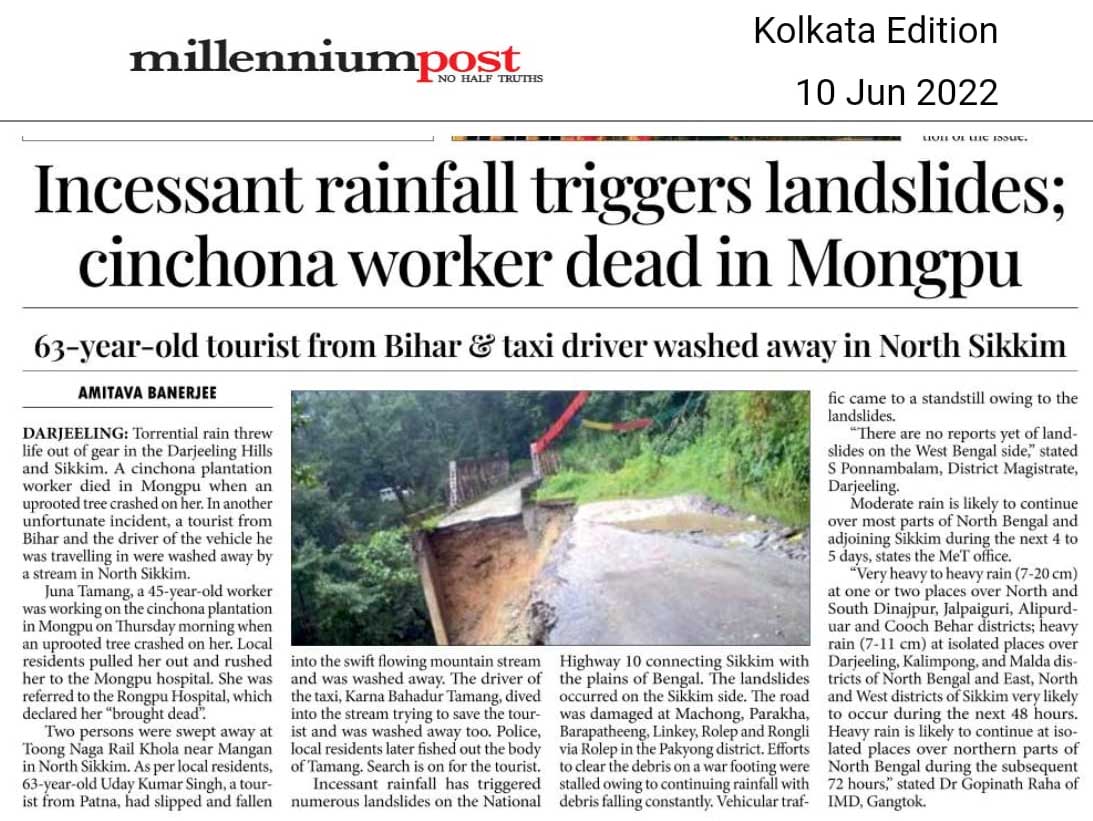
Some of the roads impacted in Sikkim due to many large and small-scale landslides are:

● 20th mile, NH10 between Singtam and Rangpo
● 17th mile Gangtok
● Singtam-Temi Tarku stretch
● Rangpo Rorathang stretch
● Jorethang-Namchi road

Latest report by the New York Times reports at least 116 fatalities due to flooding, lightning strikes and landslides in India and Bangladesh (NY Times, 2022). The Humanitarian Aid International reported that as of 22Jun22 there were 28 districts, 2,930 villages with over 19 lakh people affected and 54 fatalities in Assam.

Given below are statistics from the Assam State Disaster Management Authority from their Daily Flood Reports, from 16Jun22 - 19Jun22.

Whereas we found much information and well updated data in the Assam State Disaster Management website, there was virtually no information on the recent floods and landslides in the Meghalaya State Disaster Management website

Impact of the Deluge (Bangladesh)
The UN report is placed here

Impact of the Deluge (Bhutan)
Information not available

Images/Media reports


Ankit Mankar (Azim Premji University, Bangalore)
Shreya Gurung (SaveTheHills)
Praful Rao (SaveTheHills)